
This item below is out of stock, but another example (left) is available. To view the available item, click "Details."
Details
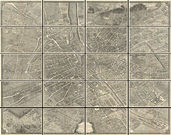
1739 Bretez Turgot View and Map of Paris, France (c. 1900 Taride issue)
$3,650.00
1739 Bretez - Turgot View and Map of Paris, France (c. 1900 Taride issue)
Paris-turgot-1900$1,500.00

Title
Plan de Paris.
1739 (original issue) / c. 1900 Taride Issue 86 x 106 in (218.44 x 269.24 cm)
1739 (original issue) / c. 1900 Taride Issue 86 x 106 in (218.44 x 269.24 cm)
Description
This is the c. 1900 Taride edition of Louis Bretez and Michel-Etienne Turgot's monumental 1739 map of Paris. Turgot's map of Paris is possibly the most ambitious urban mapping ever undertaken. Shows the whole of 18th century Paris and offers a wonderful perspective on the city prior to Baron Georges Eugène Haussmann's 19th-century redesign. Turgot, who held the mayor-like office of Prévôt des Marchands de Paris , commissioned Louis Bretez and Claude Lucas to produce this map in 1734. Oriented to the east on an axonometric projection, this map is best understood as an aerial view where in every building, window, tree, shadow and park is shown. It took the team nearly five years of exhaustive sketching and surveying to assemble this masterpiece. In order to produce the thousands of sketches and surveys required to complete this map, Bretez was issued a permit to enter every building in Paris. The completed map which consists of twenty individual sheets, can be assembled into a massive and striking display roughly 8 feet by 10 feet. Twenty loose sheets embraced in a cardboard folio, this is Alphonse Taride's c. 1900 issue of Bretez's Plan de Paris.
CartographerS
Louis Bretez (fl. 1700 - 1740) was French born sculptor and painter active in the early 18th century. Bretez was a member of the Academie Royale de Peinture et Sculpture in Paris where he specialized in perspective with regard to architecture. Bretez's greatest achievement was his production, with Claude Lucas, of the monumental Turgot Plan of Paris. This spectacular map, one of history's greatest achievements of urban cartography, occupied Bretez from 1734 to 1739. It depicts Paris from a bird's eye perspective with extraordinary detail to the level of individual buildings and trees. More by this mapmaker...
Michel-Étienne Turgot (1690-1751) a French businessman and civil administrator in the first half of the 18th century. From 1729 to 1740 he held the mayor-like office of Prévôt des Marchands de Paris ("Master of the merchants of Paris") under King Louis XV. Turgot's greatest claim to fame is his commissioning of Louis Bretez to assemble the spectacular Turgot Plan of Paris, one of the greatest feats of urban cartography ever undertaken. Turgot's more famous son, Anne-Robert-Jacques Turgot, attained prominence as a statesman and economist under Louis the XVI. Learn More...
Alphonse Taride (fl. c. 1850 - 1918) was a prolific Paris based publisher active in the late 19th and early 20th century. Publishing as "A. Taride", the firm produced a large corpus of work including numerous maps, tourist guides, histories, and pocket plans of different parts of France. With the advent of the automobile and improved roadways in the early 20th century, the name "Taride" became synonymous with high quality roadmaps. Taride had his offices at 18 - 20 Boulevard St. Denis, Paris. Learn More...
Condition
Very good condition. Each sheet exhibits original centerfold with minor toning. Moderate overall age toning. Some edge damage and verso repairs on a couple sheets, but nothing affecting printed area.
References
Hodgkiss, A. G., Discovering Antique Maps, p. 77.