Digital Image: 1915 Thurston Map of Pasadena, California and Environs
Pasadena-thurston-1915_d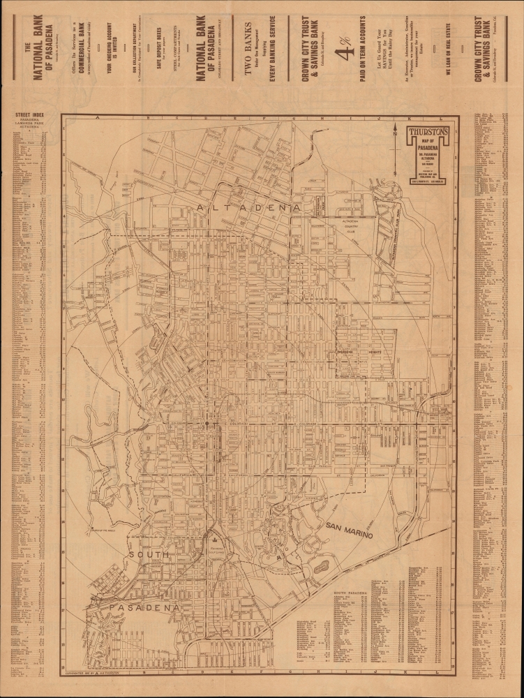

Title
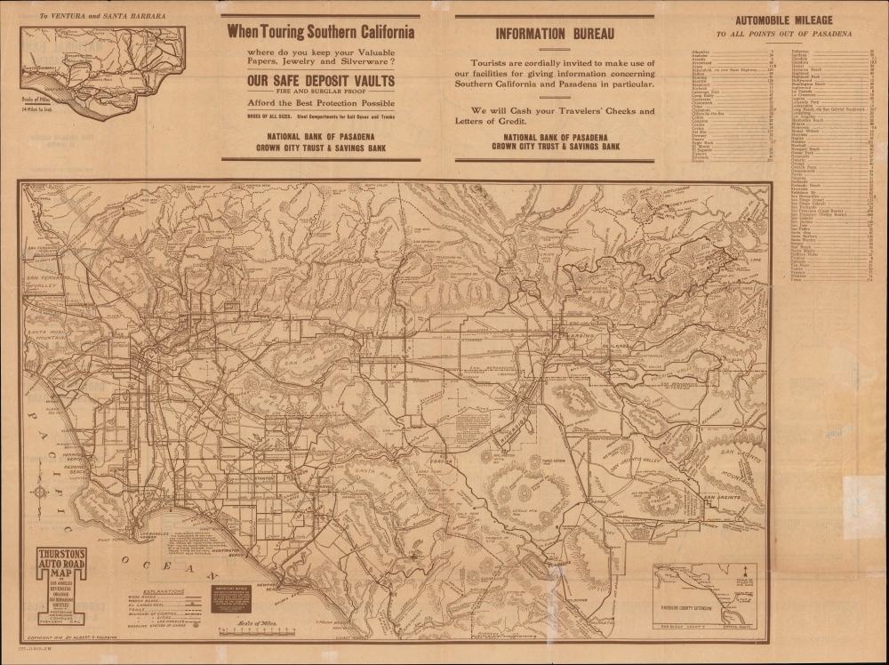
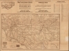
Thurston's Map of Pasadena So. Pasadena Altadena and San Marino.
1915 (dated) 26.5 x 20 in (67.31 x 50.8 cm) 1 : 20600
1915 (dated) 26.5 x 20 in (67.31 x 50.8 cm) 1 : 20600
Description
FOR THE ORIGINAL ANTIQUE MAP, WITH HISTORICAL ANALYSIS, CLICK HERE.
Digital Map Information
Geographicus maintains an archive of high-resolution rare map scans. We scan our maps at 300 DPI or higher, with newer images being 600 DPI, (either TIFF or JPEG, depending on when the scan was done) which is most cases in suitable for enlargement and printing.
Delivery
Once you purchase our digital scan service, you will receive a download link via email - usually within seconds. Digital orders are delivered as ZIP files, an industry standard file compression protocol that any computer should be able to unpack. Some of our files are very large, and can take some time to download. Most files are saved into your computer's 'Downloads' folder. All delivery is electronic. No physical product is shipped.
Credit and Scope of Use
You can use your digial image any way you want! Our digital images are unrestricted by copyright and can be used, modified, and published freely. The textual description that accompanies the original antique map is not included in the sale of digital images and remains protected by copyright. That said, we put significant care and effort into scanning and editing these maps, and we’d appreciate a credit when possible. Should you wish to credit us, please use the following credit line:
Courtesy of Geographicus Rare Antique Maps (https://www.geographicus.com).
How Large Can I Print?
In general, at 300 DPI, you should at least be able to double the size of the actual image, more so with our 600 DPI images. So, if the original was 10 x 12 inches, you can print at 20 x 24 inches, without quality loss. If your display requirements can accommodate some loss in image quality, you can make it even larger. That being said, no quality of scan will allow you to blow up at 10 x 12 inch map to wall size without significant quality loss. For more information, it is best consult a printer or reprographics specialist.
Refunds
If the high resolution image you ordered is unavailable, we will fully refund your purchase. Otherwise, digital images scans are a service, not a tangible product, and cannot be returned or refunded once the download link is used.
Cartographer
Albert G. Thurston (c. 1880 - 1930) was a publisher of maps and directories based in Los Angeles and Pasadena, California. The details of Thurston's life are uncertain, partly because several Albert Thurstons lived in the Los Angeles area at the same time. His name appeared in Pasadena city directories (some of which he published) between 1903 and 1929. Thurston published maps and other works under his name, but usually also in conjunction with the Western Map and Publishing Co., which he likely headed. Early in his career, he joined Charles Morris and other partners to form the Morris-Thurston Company, a stationary printer. Thurston looks to have lived and been based in Pasadena but also occasionally appears in records as residing in Los Angeles, where the Western Map and Publishing Co. was based until about 1915. In addition to Los Angeles and Pasadena, Thurston also published maps and directories related to the 'inland empire,' especially Riverside County, and, once it was created in 1907, Imperial County. More by this mapmaker...
References
OCLC 951433392, 986267463 (later editions).