This item has been sold, but you can get on the Waitlist to be notified if another example becomes available, or purchase a digital scan.
1748 Anson / Seale Chart of Patagonia, Tierra del Fuego, Cape Horn
Patagonia-seale-1748$125.00

Title
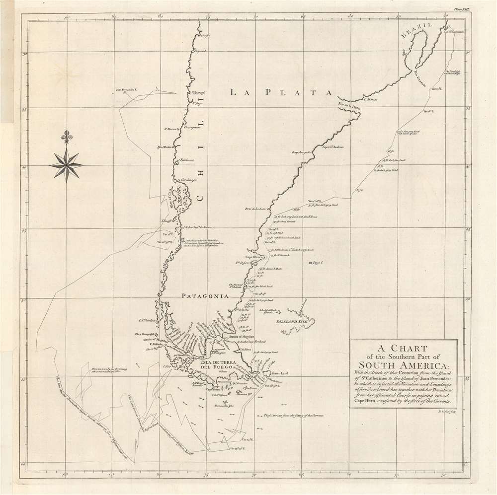
A chart of the southern part of South America, with the track of the Centurion...
1748 (undated) 19.5 x 19 in (49.53 x 48.26 cm) 1 : 8120000
1748 (undated) 19.5 x 19 in (49.53 x 48.26 cm) 1 : 8120000
Description
A product of the remarkable Anson expedition and circumnavigation, this 1748 chart was engraved by Richard Seale and appeared in George Anson et al's A Voyage Round the World, in the Years MDCCXL, I, II, III, IV. It depicts the route of Anson's flagship, the Centurion, during the disastrous first phase of the expedition around Cape Horn, before finding rest and refuge at the Juan Fernandez Archipelago.
From the start, the expedition encountered delays, obstacles, unfavorable winds, terrible storms, and other forms of bad luck. Hundreds of sailors and troops succumbed to dysentery and scurvy. Nonetheless, they managed to evade the Spanish, who likely would have trounced them in such a weakened state. After barely surviving a storm near Cape Horn and convalescing at the Juan Fernandez Archipelago, Anson continued his expedition with a significantly reduced force, raiding some coastal settlements before heading across the Pacific.
Looking to salvage something from the expedition, Anson launched an audacious and astonishingly successful attack on a Spanish galleon fleet, capturing two galleons loaded with silver. After quickly escaping to Canton, where the Chinese authorities, who regarded him as a troublesome pirate, were eager to quickly be rid of him, Anson managed to return to England without being captured or attacked by the Spanish.
The surviving members of his expedition (some one-fourth of the original members plus later additions) were greeted as heroes, met the King, and paraded their loot through the streets of London. Though marred by so many challenges and deaths, Anson's voyage became the stuff of legend, renewed British interest in the Pacific (crowned some thirty years later by Cook's voyages), and produced several capable officers in the Royal Navy who played a prominent role in subsequent decades.
A Closer Look
Coverage extends from St. Catherine's Island (Ilha de Santa Catarina), through La Plata and Patagonia, and up the Chilean coast. The approximate route of the Centurion appears along with variations, soundings, currents, anchorages, and descriptions of the seabed and other points along the route. The effect of the intense winds off Cape Horn are demonstrated by Anson's circuitous route to the west coast of South America and the variations due to currents and winds.The Anson Expedition (1740 - 1744)
Conceived of as a military expedition to capture Callao (the port of Lima, Peru), Panama, and potentially more from the Spanish, George Anson's ill-fated expedition instead became an impromptu voyage of circumnavigation. During the War of Jenkins' Ear (1739 - 1748), a conflict between Britain and Spain over trading rights and predominance of the Atlantic and Caribbean, the British sought to disrupt and even capture Spanish galleons, the financial backbone of Spain's empire. Thus, Anson was provided eight ships and 500 troops to undertake an ambitious mission in South and Central America. An ill-conceived plan to begin with, Anson's task was made impossible by the fact that his contingent of troops consisted of 'invalids' too sick to escape their assignment and fresh recruits with little to no training.From the start, the expedition encountered delays, obstacles, unfavorable winds, terrible storms, and other forms of bad luck. Hundreds of sailors and troops succumbed to dysentery and scurvy. Nonetheless, they managed to evade the Spanish, who likely would have trounced them in such a weakened state. After barely surviving a storm near Cape Horn and convalescing at the Juan Fernandez Archipelago, Anson continued his expedition with a significantly reduced force, raiding some coastal settlements before heading across the Pacific.
Looking to salvage something from the expedition, Anson launched an audacious and astonishingly successful attack on a Spanish galleon fleet, capturing two galleons loaded with silver. After quickly escaping to Canton, where the Chinese authorities, who regarded him as a troublesome pirate, were eager to quickly be rid of him, Anson managed to return to England without being captured or attacked by the Spanish.
The surviving members of his expedition (some one-fourth of the original members plus later additions) were greeted as heroes, met the King, and paraded their loot through the streets of London. Though marred by so many challenges and deaths, Anson's voyage became the stuff of legend, renewed British interest in the Pacific (crowned some thirty years later by Cook's voyages), and produced several capable officers in the Royal Navy who played a prominent role in subsequent decades.
Publication History and Census
This map was engraved by Richard Seale and based on Anson's sketches, and appeared as Plate XIII in the first edition of Anson et al's, A Voyage Round the World, in the Years MDCCXL, I, II, III, IV…, printed in London by John and Paul Knapton in 1748. Due to multiple editions (including in French and Dutch) and now digitized copies, there are more than ten OCLC listings for this map, but the physical copy of the 1748 edition is only independently cataloged with a handful of libraries and institutions in North America, Europe, and Australia, while Anson's Voyage is more widely dispersed in institutional collections.CartographerS
Richard William Seale (December 1703 - May 25, 1762) was an English a mapmaker and engraver active in London during the middle part of the 18th century. Seale was the son of Richard and Elizabeth Seale. Richard, his father, was a member of the Stationers Company, suggesting that printing and engraving must have been a family trade. Nonetheless, he did not learn the trade from his father, but rather from Samuel Parker of Clerkenwell, to whom he was apprenticed in 1719. Seale was extremely active as an engraver and publisher from about 1740 until his death in 1762. His cartographic corpus is vast; including pieces engraved for most other notable English cartographers of his period: Willdey, Baron, Toms, Rocque, Basire, Bowles, Benning, among others. In addition to cartographic work, Seale also produce numerous architectural engravings. More by this mapmaker...
Baron George Anson (23 April 1697 - 6 June 1762) was a British commodore and a wealthy noble. Following Anson's aristocratic upbringing on the family estate of Shugborough in Sataffordshire, he joined the British Navy. Anson went through a series of rapid promotions and, in 1737, was given command of a fleet of six ships charged with the mission of attacking Spanish possessions in South America. This mission was ill-equipped and unprepared for the trials ahead. Storms and navigational errors took a heavy toll on the expedition. By the time Anson reached the island of Juan Fernandez his fleet had been diminished to only three ships and his crew reduced to roughly 1/3 of its original strength. Nonetheless, Anson's persistence eventually led to the capture of an immensely rich price, the Spanish treasure galleon Nuestra Senora de Covadonga. The galleon, taken off of Cape Espiritu Santo in 1743 was loaded with silver bullion and, more importantly, charts and maps detailing the routes between Mexico and the Far East used by the Spanish for over 200 years. Knowledge of this route enabled the British navy to disrupt Spanish trade in the Pacific and thus weaken its stranglehold on the Americas. Upon his return to England Anson was hailed as a national hero and made immensely wealthy by his share of the Nuestra's treasure. Anson retired from the Navy for a career in politics and was a Member of Parliament from 1744 to 1747. Anson subsequently continued his naval career with distinction as an administrator, becoming First Lord of the Admiralty (1757-1762). Seven British warships have borne the name HMS Anson in his honor. Anson County, North Carolina, and Ansonborough in Charleston, South Carolina, are also named in Anson's honor. Learn More...
Source
Anson, George, A voyage round the world in the years MDCCXL, I, II, III, IV, by George Anson, (London, Knapton) 1748.
Condition
Very good. Light offsetting. Previous repair to left-hand margin.
References
OCLC 223381670, 945091655, 556363302.