
Seale, Richard William

Richard William Seale (December 1703 - May 25, 1762) was an English a mapmaker and engraver active in London during the middle part of the 18th century. Seale was the son of Richard and Elizabeth Seale. Richard, his father, was a member of the Stationers Company, suggesting that printing and engraving must have been a family trade. Nonetheless, he did not learn the trade from his father, but rather from Samuel Parker of Clerkenwell, to whom he was apprenticed in 1719. Seale was extremely active as an engraver and publisher from about 1740 until his death in 1762. His cartographic corpus is vast; including pieces engraved for most other notable English cartographers of his period: Willdey, Baron, Toms, Rocque, Basire, Bowles, Benning, among others. In addition to cartographic work, Seale also produce numerous architectural engravings.
California as an Island and the apocryphal inland rivers of Lahontan.
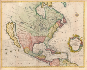
A Map of North America With the European Settlements and whatever else is remarkable in ye West Indies from the latest and best Observations.
$1,950.00
Acquire
- Digital Map Information
- Suitable for large format printing
- File Size: 14.57 MB
- File Type: ZIP / TIFF
- ICC color profile embedded
- Delivered instantly via download link
An uncommon 1745 by Richard W. Seale map of North America with California as an island. The map offers much of interest, including a fascinating mapping of the sources of the Mississippi River, California as an island, and the apocryphal geography of the Baron Lahontan. (more details)
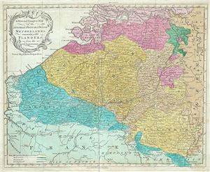
A New and Compleat Map of the Austrian, French and Dutch Netherlands, commonly call'd Flanders.
$300.00
Acquire
- Digital Map Information
- Suitable for large format printing
- DPI: 300
- File Size: 6.99 MB
- File Type: ZIP / TIFF
- ICC color profile embedded
- Delivered instantly via download link
This is an attractive c. 1760 map of Flanders engraved by Richard William Seale. The map depicts modern day Belgium and Luxemburg along with parts of Germany, France and Holland, a region commonly called Flanders at the time. Covers from Rotterdam south as far as ... (more details)