1846 Bradford Map of Pennsylvania
Pennsylvania-bradford-1846$250.00

Title
Pennsylvania.
1846 (dated) 12 x 15 in (30.48 x 38.1 cm) 1 : 1393920
1846 (dated) 12 x 15 in (30.48 x 38.1 cm) 1 : 1393920
Description
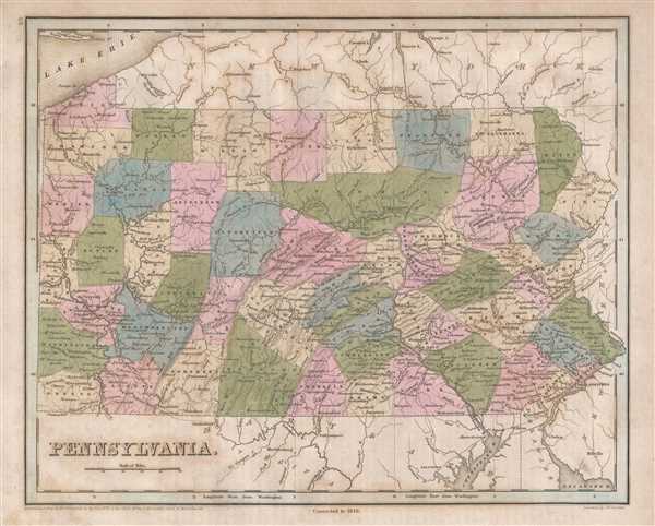
This is an 1846 Thomas G. Bradford map of Pennsylvania. The map depicts the region fromOhio to New Jersey and from Lake Erie and New York to Virginia. As is the case with the majority of the maps included in A Universal Illustrated Atlas, the transportation network in Pennsylvania is illustrated and includes system unlike any other in the country at the time. Power-brokers in the state wanted a way to transport goods between Philadelphia and Pittsburgh, a distance of nearly 400 miles. Instead of concentrating on one form of transport, i.e. canal or railroad, they decided to use both. What Bradford labels the 'Grand Trunk' line is a mix of canals and railroads covering the distance between Philadelphia and Pittsburgh, utilizing the most effective method of transportation for the terrain. Other canals and railroads were built in other parts of the state, even connecting the Pennsylvania transportation network with that of New York, including the Erie Canal.
Highly detailed, each county is illustrated, labeled, and shaded a different color to allow for easy differentiation. Numerous towns and villages are labeled, including Philadelphia. Pittsburgh, Williamsport, and Harrisburg. The Susquehanna, Allegany, Youghiogheny, and Monongahela Rivers are all illustrated, along with myriad other smaller rivers and creeks.
This map was engraved by George Boynton and published in the 1846 edition of Bradford and Goodrich's A Universal Illustrated Atlas.
CartographerS
Thomas Gamaliel Bradford (1802 - 1887) was born in Boston, Massachusetts, where he worked as an assistant editor for the Encyclopedia Americana. Bradford's first major cartographic work was his revision and subsequent republishing of an important French geography by Adrian Balbi, Abrege de Geographie published in America as Atlas Designed to Illustrate the Abridgment of Universal Geography, Modern and Ancient. Afterwards Bradford revised and expanded this work into his own important contributions to American cartography, the 1838 An Illustrated Atlas Geographical, Statistical and Historical of the United States and Adjacent Countries. Bradford's cartographic work is significant as among the first to record Texas as an independent nation. In his long career as a map publisher Bradford worked with William Davis Ticknor of Boston, Freeman Hunt of New York, Charles De Silver of Philadelphia, John Hinton, George Washington Boynton, and others. We have been able to discover little of Bradford's personal life. More by this mapmaker...
George Washington Boynton (fl. c. 1830 - 1850) was a Boston based cartographer and map engraver active in the first half of the 19th century. Boynton engraved and compiled maps for numerous publishers including Thomas Bradford, Nathaniel Dearborn, Daniel Adams, and S. G. Goodrich. His most significant work is most likely his engraving of various maps for Bradford's Illustrated Atlas, Geographical, Statistical, and Historical, of the United States and the Adjacent Countries and Universal Illustrated Atlas. He also engraved for the Boston Almanac. In 1835, Boynton is listed as an employee of the Boston Bewick Company, an engraving, stereotype, and printing concern based at no. 47 Court Street, Boston. Little else is known of his life. Learn More...
Source
Bradford, T. G. and Goodrich, S. G., A Universal Illustrated Atlas, exhibiting a Geographical, Statistical, and Historical view of the World, (Boston: Charles D. Strong) 1846.
The Universal Illustrated Atlas is one of the great American atlases of the first half of the 19th century. The atlas was first published in 1838 under the imprint of Charles D. Strong. It replaced and superseded Bradford's earlier smaller format Illustrated Atlas, Geographical, Statistical, and Historical, of the United States and the Adjacent Countries. Numerous reissues of the Universal Illustrated Atlas followed until about 1848. Although there are minor variations between the editions, most contain about 50 maps, the majority of which focus on the United States. Bradford's atlases are significant for recording North America during the Republic of Texas Era. In later editions, particularly the 1846 edition, Bradford illustrates the boom in railroad construction, possibly with the idea that his maps would aid travelers in planning journeys by rail. It was compiled by Thomas Gamaliel Bradford and Samuel Griswold Goodrich with most of the plates engraved by George Washington Boynton (fl. c. 1830 - 1850). Other contributors include Thomas Gordon (1778 - 1848), Fielding Lucas Jr. (1781 - 1854), Samuel Edward Stiles (1844 - 1901), Sherman and Smith (fl. c. 1829 - 1855), and Horace Thayer (1811 - c. 1874).
Condition
Very good. Even overall toning. Light transferrence. Blank on verso.
References
Rumsey 0089.016 (1838 edition).