Digital Image: 1866 Daddow Coal and Geological Map of Northeastern Pennsylvania
PennsylvaniaAnthracite-daddow-1866_d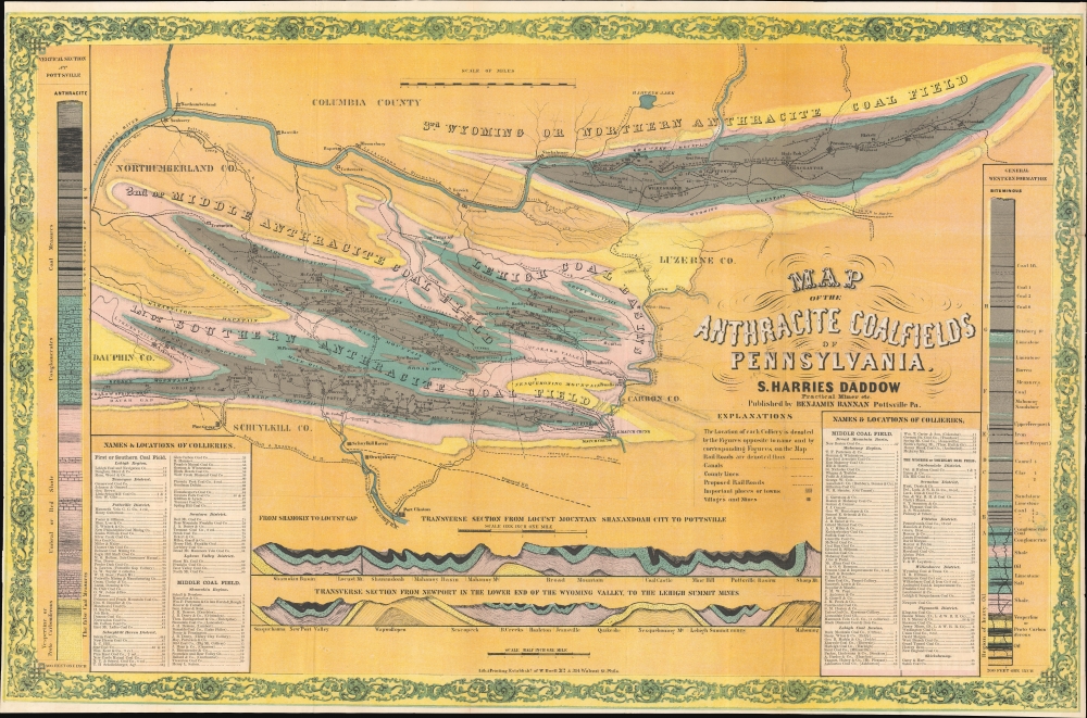


Title
Map of the Anthracite Coalfields of Pennsylvania.
1866 (undated) 22.5 x 34 in (57.15 x 86.36 cm) 1 : 126720
1866 (undated) 22.5 x 34 in (57.15 x 86.36 cm) 1 : 126720
Description
FOR THE ORIGINAL ANTIQUE MAP, WITH HISTORICAL ANALYSIS, CLICK HERE.
Digital Map Information
Geographicus maintains an archive of high-resolution rare map scans. We scan our maps at 300 DPI or higher, with newer images being 600 DPI, (either TIFF or JPEG, depending on when the scan was done) which is most cases in suitable for enlargement and printing.
Delivery
Once you purchase our digital scan service, you will receive a download link via email - usually within seconds. Digital orders are delivered as ZIP files, an industry standard file compression protocol that any computer should be able to unpack. Some of our files are very large, and can take some time to download. Most files are saved into your computer's 'Downloads' folder. All delivery is electronic. No physical product is shipped.
Credit and Scope of Use
You can use your digial image any way you want! Our digital images are unrestricted by copyright and can be used, modified, and published freely. The textual description that accompanies the original antique map is not included in the sale of digital images and remains protected by copyright. That said, we put significant care and effort into scanning and editing these maps, and we’d appreciate a credit when possible. Should you wish to credit us, please use the following credit line:
Courtesy of Geographicus Rare Antique Maps (https://www.geographicus.com).
How Large Can I Print?
In general, at 300 DPI, you should at least be able to double the size of the actual image, more so with our 600 DPI images. So, if the original was 10 x 12 inches, you can print at 20 x 24 inches, without quality loss. If your display requirements can accommodate some loss in image quality, you can make it even larger. That being said, no quality of scan will allow you to blow up at 10 x 12 inch map to wall size without significant quality loss. For more information, it is best consult a printer or reprographics specialist.
Refunds
If the high resolution image you ordered is unavailable, we will fully refund your purchase. Otherwise, digital images scans are a service, not a tangible product, and cannot be returned or refunded once the download link is used.
Cartographer S
Samuel Harries Daddow (March 14, 1827 - March 23, 1875) was an English-American mining engineer and author. Born in Cornwall, England, Samuel immigrated to the United States where he became involved with the Pennsylvania Anthracite Boom. Along with journalist Benjamin Bannon (1807 - 1875), he published Coal, Iron, and Oil, or the Practical Miner, at the time the most lavishly expensive single volume work published in the United States. He married Esther Anne Beadle in 1856, with whom he had one child. More by this mapmaker...
Benjamin Bannan (April 22, 1807 - July 29, 1875) was a publisher, journalist, and political economist based in Pottsville, Pennsylvania in the mid-19th century. Bannan was born in Union City, Pennsylvania, into a Pennsylvania farming family. His father died when he was eight years old, forcing him to quit school to run the family farm. Nonetheless, Bannan taught himself to read and, inspired by the local newspaper (Village Record), wanted to become a publisher. At 15, he took a job at the Berks and Schuylkill Journal, where he learned the printing and publishing business. He rose through the ranks to become a partner. In 1829, Bannan moved to Pottsville, Pennsylvania, the epicenter of Pennsylvania's thriving coal mining industry. There, he founded the Miners' Journal, which he published for more than 40 years. Politically, Bannan was a Whig and a Republican, espousing nativist 'free labor' ideologies, believing that social mobility was an inherent aspect of economic expansion. His ideal society had an independent middle class made up of small entrepreneurial businesses - like coal mining industrialists. He was anti-immigration and, in 1857, mentioned the Molly Maguires in Miners' Journal, linking the secretive group to local terrorism. It is among the first known public references to the Molly Maguires. Along with Samuel Harries Daddow (1827 - 1875), he published Coal, Iron, and Oil, one of the most expensive single-volume works published in the United States at the time. He retired around 1873 and spent his retirement gardening. He died two years later. Learn More...
References
Boston Public Library, Leventhal Center, G3821.H9 1866 .D33. OCLC 126720. OCLC 37950843.