1838 Bradford Map of Philadelphia
Philadelphia-bradford-1838$300.00

Title
Philadelphia.
1838 (dated) 15 x 12 in (38.1 x 30.48 cm) 1 : 16600
1838 (dated) 15 x 12 in (38.1 x 30.48 cm) 1 : 16600
Description
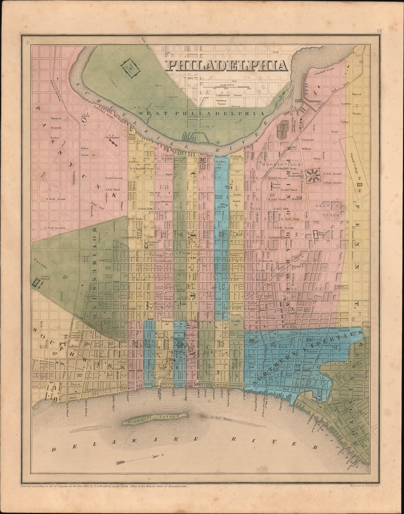
This is an 1838 Thomas G. Bradford map of Philadelphia, Pennsylvania.
A Closer Look
Oriented to the west, the plan embraces central Philadelphia, bounded on the west by the Schuylkill River, and the east by the Delaware River. It is color coded and numbered by ward, with major buildings, civic sites, squares, and streets illustrated and named. Parts of West Philadelphia, across the Schuylkill, are noted. Major rail lines enter the city from Baltimore to the south, Trenton to the north, and the Pennsylvania coal region to the northwest.Historical Context
In 1838, Philadelphia was a bustling hub of culture, commerce, and innovation, solidifying its reputation as the 'Workshop of the World'. As one of America's largest cities, it benefited from the rapid rise of industrialization, with diverse manufacturing sectors ranging from textiles to ironworks. It was also, as this map was being produced, the center of the American printing industry. The city's intellectual and cultural life flourished, with the Franklin Institute and other organizations promoting science and education. However, Philadelphia wasn't immune to the economic challenges posed by the Panic of 1837, which affected businesses and led to widespread financial distress. Meanwhile, the city's growth also gave rise to social and political tensions, as differing groups competed for influence and representation.Publication History
This map was engraved by George Boynton in 1838 and published in the 1841 edition of Bradford and Goodrich's A Universal Illustrated Atlas. The map received regular updates through the late 1840s.CartographerS
Thomas Gamaliel Bradford (1802 - 1887) was born in Boston, Massachusetts, where he worked as an assistant editor for the Encyclopedia Americana. Bradford's first major cartographic work was his revision and subsequent republishing of an important French geography by Adrian Balbi, Abrege de Geographie published in America as Atlas Designed to Illustrate the Abridgment of Universal Geography, Modern and Ancient. Afterwards Bradford revised and expanded this work into his own important contributions to American cartography, the 1838 An Illustrated Atlas Geographical, Statistical and Historical of the United States and Adjacent Countries. Bradford's cartographic work is significant as among the first to record Texas as an independent nation. In his long career as a map publisher Bradford worked with William Davis Ticknor of Boston, Freeman Hunt of New York, Charles De Silver of Philadelphia, John Hinton, George Washington Boynton, and others. We have been able to discover little of Bradford's personal life. More by this mapmaker...
George Washington Boynton (fl. c. 1830 - 1850) was a Boston based cartographer and map engraver active in the first half of the 19th century. Boynton engraved and compiled maps for numerous publishers including Thomas Bradford, Nathaniel Dearborn, Daniel Adams, and S. G. Goodrich. His most significant work is most likely his engraving of various maps for Bradford's Illustrated Atlas, Geographical, Statistical, and Historical, of the United States and the Adjacent Countries and Universal Illustrated Atlas. He also engraved for the Boston Almanac. In 1835, Boynton is listed as an employee of the Boston Bewick Company, an engraving, stereotype, and printing concern based at no. 47 Court Street, Boston. Little else is known of his life. Learn More...
Source
Bradford, T. G. and Goodrich, S. G., A Universal Illustrated Atlas, exhibiting a Geographical, Statistical, and Historical view of the World, (Boston: Charles D. Strong) 1841.
The Universal Illustrated Atlas is one of the great American atlases of the first half of the 19th century. The atlas was first published in 1838 under the imprint of Charles D. Strong. It replaced and superseded Bradford's earlier smaller format Illustrated Atlas, Geographical, Statistical, and Historical, of the United States and the Adjacent Countries. Numerous reissues of the Universal Illustrated Atlas followed until about 1848. Although there are minor variations between the editions, most contain about 50 maps, the majority of which focus on the United States. Bradford's atlases are significant for recording North America during the Republic of Texas Era. In later editions, particularly the 1846 edition, Bradford illustrates the boom in railroad construction, possibly with the idea that his maps would aid travelers in planning journeys by rail. It was compiled by Thomas Gamaliel Bradford and Samuel Griswold Goodrich with most of the plates engraved by George Washington Boynton (fl. c. 1830 - 1850). Other contributors include Thomas Gordon (1778 - 1848), Fielding Lucas Jr. (1781 - 1854), Samuel Edward Stiles (1844 - 1901), Sherman and Smith (fl. c. 1829 - 1855), and Horace Thayer (1811 - c. 1874).
Condition
Very good. Even overall toning. Some spotting.
References
Rumsey 4453.019.