1882 Smith Map of Philadelphia
Philadelphia-smith-1882$850.00


Title
New map of the city of Philadelphia : from the latest city surveys.
1882 (dated) 38.25 x 27.75 in (97.155 x 70.485 cm) 1 : 21250
1882 (dated) 38.25 x 27.75 in (97.155 x 70.485 cm) 1 : 21250
Description
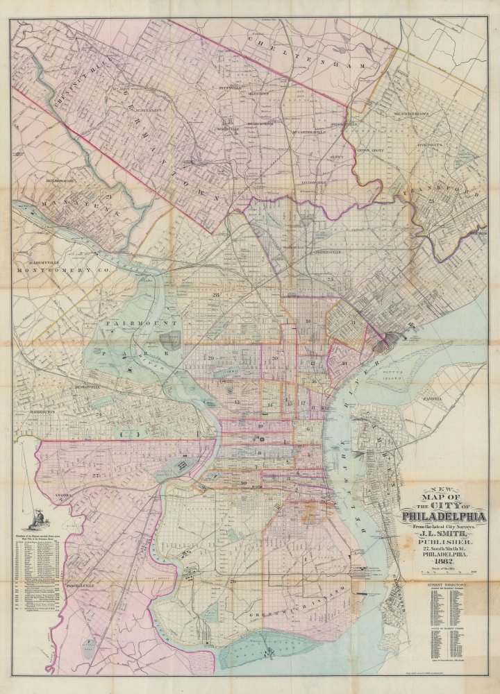
A rare 1882 first edition example of John L. Smith's large-scale folding map of Philadelphia. It depicts the city at a time when it was growing quickly and undertaking projects to reflect its size and ambition, such as the enormous new city hall, constructed between 1871 and 1901.
Grand public works and displays were launched to match the city's size and ambitions, most notably the 1876 Centennial Exhibition, held in Fairmount Park. Two of the fair's structures are retained here and lasted well into the 20th century: the Horticultural Hall was damaged by a hurricane in the 1950s and demolished, while the Art Gallery remains as Memorial Hall. Another major project in these years was the construction of a massive new city hall, near center towards bottom here, a thirty-year-long project resulting in what was, at the time, the tallest habitable building and the tallest secular structure in the world, as well as the largest public building in the U.S.
A Closer Look
Oriented slightly towards the northwest, the city is divided into numbered wards, with the historic core set between the Delaware and Schuylkill Rivers surrounded by growing neighborhoods on all sides, including portions of New Jersey across the Delaware River. The impressive rail and industrial network is evident, including naval facilities, depots, gas works, and oil refineries. Streets, parks, cemeteries, reservoirs, schools, and public institutions are labeled, including the wheel-shaped Eastern State Penitentiary, one of the city's most distinctive structures. A street directory is provided at bottom-right, while a table at left lists the highest point in each ward. A series of concentric rings spaced out by one-mile increments emanate from the city center.Historical Context
Philadelphia's population expanded continuously throughout the 19th century, particularly in the years following the U.S. Civil War (in 1854, the city's territory grew substantially by 'consolidating' surrounding communities). Immigrants from Ireland and Germany were joined by increasing numbers of immigrants from Eastern Europe, while African-American migrants from the South came to join the already sizable population of freedmen who lived in the city before the war (the 7th Ward, south of City Hall, was the subject of W.E.B. DuBois' classic 1899 work The Philadelphia Negro, the first sociological case study of a Black community in the United States).Grand public works and displays were launched to match the city's size and ambitions, most notably the 1876 Centennial Exhibition, held in Fairmount Park. Two of the fair's structures are retained here and lasted well into the 20th century: the Horticultural Hall was damaged by a hurricane in the 1950s and demolished, while the Art Gallery remains as Memorial Hall. Another major project in these years was the construction of a massive new city hall, near center towards bottom here, a thirty-year-long project resulting in what was, at the time, the tallest habitable building and the tallest secular structure in the world, as well as the largest public building in the U.S.
Publication History and Census
This map was prepared and published by John L. Smith in 1882. Smith issued a map with this title and format into the 1920s, but this appears to be the first edition. The present edition is held by the Athenaeum of Philadelphia, the Jenkins Law Library, the Library Company of Philadelphia, the Historical Society of Pennsylvania, the University of Houston, and the Bibliothèque nationale de France, and has no known history on the market.Cartographer
John L. Smith (March 19, 1846 - April 1, 1921) was a Philadelphia based stationer, map seller, publisher, and printer active in the late 19th and early 20th centuries. Smith served in the Civil war with Company K, 118th Pennsylvania, the 'Corn Exchange Regiment' from roughly 1862. He served in the Battle of North Anna and Bethesda Church, where he was wounded. He mustered out of service in 1865 and settled in Philadelphia. Smith subsequently worked with Rufus L. Barnes (1794 - 1868), whose business he acquired in 1868. His offices were at 27 South Sixth Street, Philadelphia. He retired from the map business in 1920. Smith rose to prominence and wealth and, when he died, left a large estate of $54,500 USD to charity. He had no children and lived as a bachelor at the Columbia Club, 1600 North Broad Street, until his death of a heart attack in 1921. He had a brother, William C. Smith, who survived him. More by this mapmaker...
Condition
Average. Closed verso repairs on fold lines, minor wear along fold lines. Small areas of professional infill at fold intersections.
References
OCLC 38398591.