Digital Image: 1869 Toudy and Dye Wall Map of Philadelphia
Philadelphia-toudy-1869_d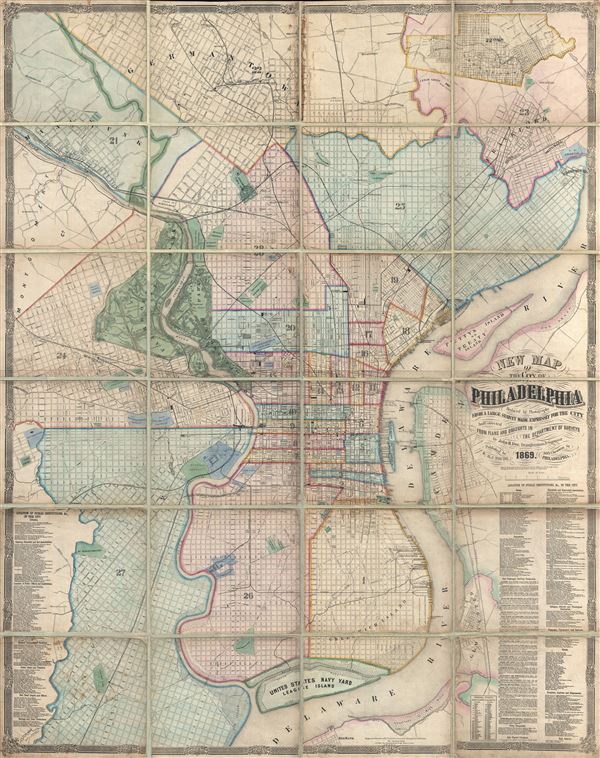

Title
New Map of the City of Philadelphia, reduced by Photography from a large survey made expressly for the City and corrected from Plans and Draughts in the Department of Surveys, by John. H. Dye, Draughtsman and Surveyor.
1869 (dated) 62 x 51 in (157.48 x 129.54 cm) 1 : 13400
1869 (dated) 62 x 51 in (157.48 x 129.54 cm) 1 : 13400
Description
FOR THE ORIGINAL ANTIQUE MAP, WITH HISTORICAL ANALYSIS, CLICK HERE.
Digital Map Information
Geographicus maintains an archive of high-resolution rare map scans. We scan our maps at 300 DPI or higher, with newer images being 600 DPI, (either TIFF or JPEG, depending on when the scan was done) which is most cases in suitable for enlargement and printing.
Delivery
Once you purchase our digital scan service, you will receive a download link via email - usually within seconds. Digital orders are delivered as ZIP files, an industry standard file compression protocol that any computer should be able to unpack. Some of our files are very large, and can take some time to download. Most files are saved into your computer's 'Downloads' folder. All delivery is electronic. No physical product is shipped.
Credit and Scope of Use
You can use your digial image any way you want! Our digital images are unrestricted by copyright and can be used, modified, and published freely. The textual description that accompanies the original antique map is not included in the sale of digital images and remains protected by copyright. That said, we put significant care and effort into scanning and editing these maps, and we’d appreciate a credit when possible. Should you wish to credit us, please use the following credit line:
Courtesy of Geographicus Rare Antique Maps (https://www.geographicus.com).
How Large Can I Print?
In general, at 300 DPI, you should at least be able to double the size of the actual image, more so with our 600 DPI images. So, if the original was 10 x 12 inches, you can print at 20 x 24 inches, without quality loss. If your display requirements can accommodate some loss in image quality, you can make it even larger. That being said, no quality of scan will allow you to blow up at 10 x 12 inch map to wall size without significant quality loss. For more information, it is best consult a printer or reprographics specialist.
Refunds
If the high resolution image you ordered is unavailable, we will fully refund your purchase. Otherwise, digital images scans are a service, not a tangible product, and cannot be returned or refunded once the download link is used.
Cartographer S
Henry J. Toudy (fl. c. 1857 - c. 1877) was an American lithographer, engraver, and map publisher active in Philadelphia during the middle part of the 19th century. Little is known of Toudy's parentage or early life, but he established a steam lithography press in Philadelphia around 1856. Toudy was best known as a printer of city and town views, with many such productions bearing his imprint. He also published portraits, railroad bonds, stock certificates, and map. Toudy's original offices were located at 503 and 505 Chestnuts Streets. Insurance records suggest that Toudy's Chestnut Street offices were gutted by fire on March 25, 1879. Records suggest that the Toudy firm was reestablished in 1884 at 829 Walnut Street. In 1892 a Henry J. Toudy is recorded as the owner of the Greenback Coilliery, a mine in Shamokin, PA famous for a terrible explosion that had occurred years earlier under another owner. It is unclear if they are the same person or possibly related, but such is neither unlikely nor impossible. More by this mapmaker...
John H. Dye (September 9, 1833 - 19??) was a Philadelphia based draughtsman, government official, surveyor, and mapmaker active in the middle part of the 19th century. Dye was born in Kensington, Pennsylvania, to which his parents William and Christiana Dye migrated after leaving Rhode Island. Dye studied civil engineering under James P. Davis, his uncle, and took a position under Strickland Niece, chief engineer of Philadelphia. In 1865 Dye was appointed to create and manage the Registry Bureau of the Philadelphia Survey Department, a position which he held for 31 years. The bureau, under Dye's direction compiled and sold Philadelphia city and district plans for both official and public use, these included civic improvement, legal matters, land purchase and sale, cemetery management, and the construction of the city's sewer system. Dye served as a Union officer in the American Civil War. He was also active in his local Masonic Lodge, where he attained the 32nd degree of the Scottish Rite. Later, in 1885 he was elected Chair of the Engineers Club of Philadelphia. Die was active until at least 1896. The date and place of his death is unknown. Learn More...
References
Huntington Library, 093:575 M. OCLC 495093079.