Digital Image: 1949 McGrew City Plan or Map of Phoenix, Arizona
Phoenix-mcgrew-1949_d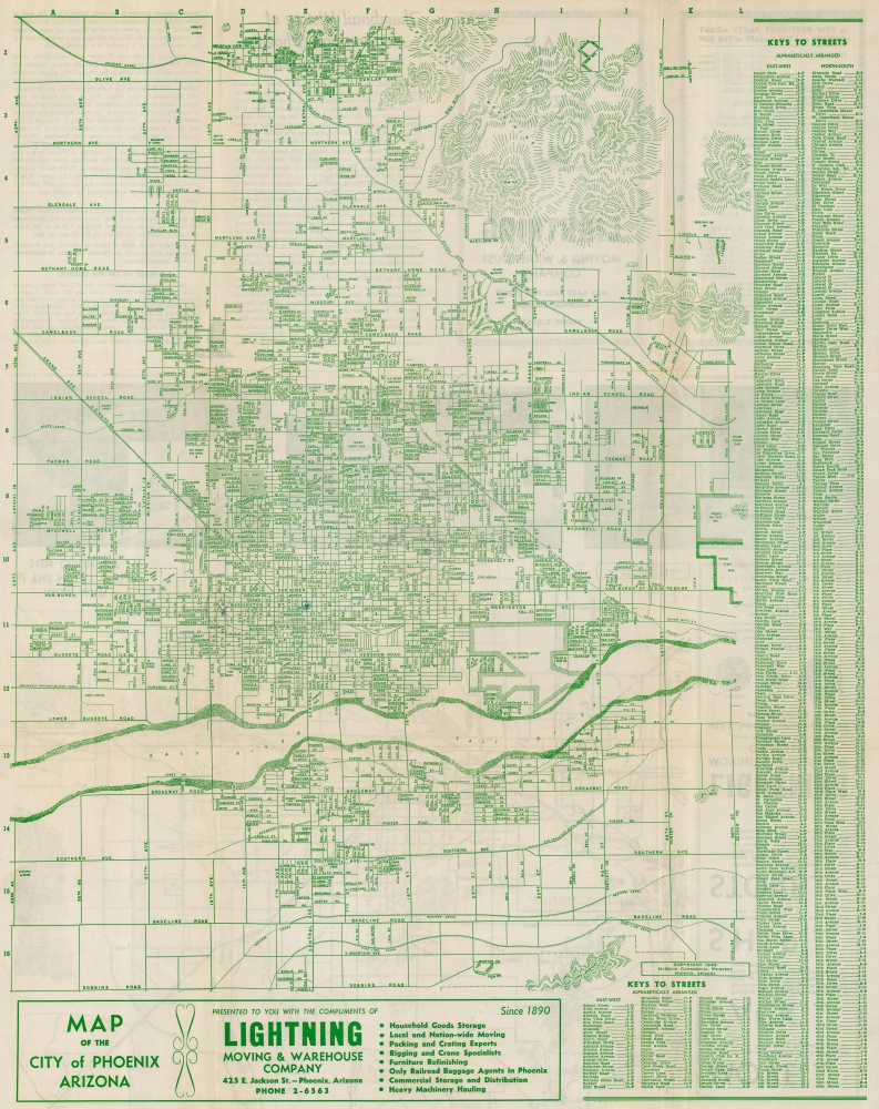

Title
Map of the City of Phoenix Arizona.
1949 (dated) 23.5 x 18.5 in (59.69 x 46.99 cm)
1949 (dated) 23.5 x 18.5 in (59.69 x 46.99 cm)
Description
FOR THE ORIGINAL ANTIQUE MAP, WITH HISTORICAL ANALYSIS, CLICK HERE.
Digital Map Information
Geographicus maintains an archive of high-resolution rare map scans. We scan our maps at 300 DPI or higher, with newer images being 600 DPI, (either TIFF or JPEG, depending on when the scan was done) which is most cases in suitable for enlargement and printing.
Delivery
Once you purchase our digital scan service, you will receive a download link via email - usually within seconds. Digital orders are delivered as ZIP files, an industry standard file compression protocol that any computer should be able to unpack. Some of our files are very large, and can take some time to download. Most files are saved into your computer's 'Downloads' folder. All delivery is electronic. No physical product is shipped.
Credit and Scope of Use
You can use your digial image any way you want! Our digital images are unrestricted by copyright and can be used, modified, and published freely. The textual description that accompanies the original antique map is not included in the sale of digital images and remains protected by copyright. That said, we put significant care and effort into scanning and editing these maps, and we’d appreciate a credit when possible. Should you wish to credit us, please use the following credit line:
Courtesy of Geographicus Rare Antique Maps (https://www.geographicus.com).
How Large Can I Print?
In general, at 300 DPI, you should at least be able to double the size of the actual image, more so with our 600 DPI images. So, if the original was 10 x 12 inches, you can print at 20 x 24 inches, without quality loss. If your display requirements can accommodate some loss in image quality, you can make it even larger. That being said, no quality of scan will allow you to blow up at 10 x 12 inch map to wall size without significant quality loss. For more information, it is best consult a printer or reprographics specialist.
Refunds
If the high resolution image you ordered is unavailable, we will fully refund your purchase. Otherwise, digital images scans are a service, not a tangible product, and cannot be returned or refunded once the download link is used.
Cartographer
McGrew Printing and Lithographing Company (1890 - c. 1990) was an American printing and lithographing firm based in Phoenix, Arizona. Opened on May 1, 1890, the original printing plant was the job printing department for the Arizona Republican. The print shop grew alongside the newspaper, moving several times around Phoenix between 1900 and 1930. Dan McGrew and Dr. Trevor Browne bought the printing company in 1945 and renamed it the McGrew Printing Company. Business continued to grow and another move to a larger building was necessary. In the 1950s McGrew Printing added offset printing to its offerings and changed its name to McGrew Printing and Lithographing Company. McGrew and Browne sold the company to Kenny Watson and Charles Langford in 1968 and Watson retired as president of the company in 1978. We have been able to find very little information concerning McGrew Printing following 1978, but we did uncover an job advertisement for a 'paste-up person' for McGrew Printing in Phoenix in April 1990. More by this mapmaker...
References
OCLC 78495374.