This item has been sold, but you can get on the Waitlist to be notified if another example becomes available, or purchase a digital scan.
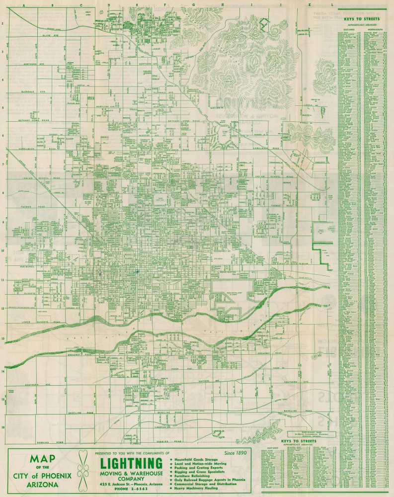
1949 McGrew City Plan or Map of Phoenix, Arizona
Phoenix-mcgrew-1949$125.00

Title
Map of the City of Phoenix Arizona.
1949 (dated) 23.5 x 18.5 in (59.69 x 46.99 cm)
1949 (dated) 23.5 x 18.5 in (59.69 x 46.99 cm)
Description
This is a 1949 McGrew Commercial Printery city map of Phoenix, Arizona, distributed by the Lightning Moving and Warehouse Company. The map captures Phoenix during its post-World War II (1939 - 1945) boom, when a combination of commercially available air conditioning, military activity, and economic prosperity transformed the city.
A Closer Look
As befits a map distributed by a moving company, Phoenix's street network appears in detail, with nearly all the streets labeled. Schools, hospitals, parks, airports, and even the state fairgrounds are identified. The Phoenix Mountains occupy the upper right. The 'Atchison, Topeka, and Santa Fe Railroad' and the 'Southern Pacific Railroad' both appear, with Union Station named. An alphabetic street index occupies the right border.Historical Context
In 1949, Phoenix, Arizona, was evolving from a small, agriculture-based town into a burgeoning metropolitan area. Post-World War II economic prosperity and the advent of air conditioning technology significantly spurred Phoenix's growth, making the hot desert climate manageable and even attractive. The city's population boomed, leading widespread urbanization. Phoenix's economy during this time was diversifying, gradually moving away from its agricultural roots to include manufacturing, retail, and a growing service sector. The city also became a hub for military activity, with several bases and training facilities being established, reflecting the ongoing Cold War tensions.Publication History and Census
This map was created and published by McGrew Commercial Printery and distributed 'Compliments of Lightning Moving and Warehouse Company' in 1949. We note five examples of the 1949 edition cataloged in OCLC which are part of the collections at Yale University, the University of Wisconsin Milwaukee, the Arizona Historical Society Southern Arizona Division, Arizona State University, and the Phoenix Public Library. We also note editions cataloged in OCLC from 1947, 1954, and 1959.Cartographer
McGrew Printing and Lithographing Company (1890 - c. 1990) was an American printing and lithographing firm based in Phoenix, Arizona. Opened on May 1, 1890, the original printing plant was the job printing department for the Arizona Republican. The print shop grew alongside the newspaper, moving several times around Phoenix between 1900 and 1930. Dan McGrew and Dr. Trevor Browne bought the printing company in 1945 and renamed it the McGrew Printing Company. Business continued to grow and another move to a larger building was necessary. In the 1950s McGrew Printing added offset printing to its offerings and changed its name to McGrew Printing and Lithographing Company. McGrew and Browne sold the company to Kenny Watson and Charles Langford in 1968 and Watson retired as president of the company in 1978. We have been able to find very little information concerning McGrew Printing following 1978, but we did uncover an job advertisement for a 'paste-up person' for McGrew Printing in Phoenix in April 1990. More by this mapmaker...
Condition
Very good. Light wear along original fold lines. Closed margin tears professionally repaired on verso. Map of the Heart of Sun Country on verso.
References
OCLC 78495374.