This copy is copyright protected.
Copyright © 2024 Geographicus Rare Antique Maps
1975 Chesser Physiographic Map of the Earth showing Sub-Oceanic Topography
PhysiographicEarth-chesser-1975

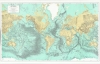

William Lagrand Chesser (1940 - present) is a geologist, scientific illustrator, and artist who primarily worked as an exploration geologist in the oil industry in Colorado and Texas. Born in Pensacola, Florida, he served in the U.S. Air Force and then earned a bachelor's and master's in geology at Brigham Young University. In addition to his work as a geologist, Chesser illustrated science textbooks, a series of works about the Grand Canyon, and a large 'Physiographic map of the Earth,' published in several editions in the 1970s and 1980s. More by this mapmaker...
Marie Tharp (July 30, 1920 - August 23, 2006) was a prominent American oceanographic cartographer and geologist - recognized as a pioneer in the male-dominated world of geology. Tharp was born in Ypsilanti, Michigan. She was introduced to mapmaking through her father, who was a surveyor for the U.S. Department of Agriculture. She studied at the University of Ohio, earning Music and English degrees. During World War II, she earned a Masters in Geology at the University of Michigan, graduating in 1944, and later a second bachelor's in mathematics (1948). She first worked as a research assistant at Lamont Geological Laboratory in Columbia University in New York. Tharp was Bruce Charles Heezen's (1924 - 1977) assistant while he was a graduate student, and he gave her the task of drafting seafloor profiles. Her discoveries of the Mid-Atlantic Rift and the Mid-Atlantic Ridge, while initially dismissed because of her gender, eventually led to a life-long collaboration with Heezen. Today, Tharp is best known for her decades long project to map the ocean floors with sonar imaging. This revolutionary work contributed to our modern understanding undersea geography, plate tectonics, and continental drift. Ironically, women at that time were unwelcome on scientific marine voyages, so while she mapped the oceans, she never personally went to sea. Her published maps include the North Atlantic (1957), South Atlantic (1961), Indian Ocean (1964), and the world (1977). She remained at Columbia University until retiring in 1983. Learn More...
Bruce Charles Heezen (April 11, 1924 - June 21, 1977) was an American geologist active at New York's Columbia University. Heezen was born in Viton, Iowa. He graduated from the University of Iowa in 1947 and went on to an MA (1952) and PhD (1957) at Columbia University. There he met the pioneering female geologist, Marie Tharp (1920 - 2006), with whom he collaborated to map the ocean's floors for some 30 years. Tharp was Heezen's assistant while he was a graduate student. When she showed Heezen that her plotting of the North Atlantic revealed a rift valley, Heezen dismissed it as 'girl talk'. She persisted and they eventually discovered that not only was there a North Atlantic rift valley, but a mountain range with a central valley that spanned the earth. Heezen died of a heart attack in 1977 while aboard the NR-1 submarine studying the Mid-Atlantic Ridge near Iceland. Learn More...
Copyright © 2024 Geographicus Rare Antique Maps | Geographicus Rare Antique Maps
This copy is copyright protected.
Copyright © 2024 Geographicus Rare Antique Maps