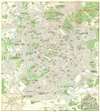
1968 Moscow City Planning Office Pictorial Map of Moscow in German
PictorialMoscow-cityplanning-1968$250.00


Title
Moskau Illustriertes Schema.
1968 (dated) 30 x 27 in (76.2 x 68.58 cm) 1 : 23000
1968 (dated) 30 x 27 in (76.2 x 68.58 cm) 1 : 23000
Description
A reminder of Cold War-era tourism, this is a 1968 Moscow City Planning office pictorial city plan or map of Moscow, Russia. This map, printed entirely in German was intended to court East German tourism to Moscow. Three hundred sixty-nine locations throughout Moscow are numerically identified and correspond with an index printed on the verso. These include museums, theaters, churches, and hotels. Numerous famous landmarks are illustrated in profile, such as St. Basil's Cathedral, the Bolshoi Theatre, the Cathedral of Christ the Savior, the Kotelnicheskaya Embankment Building, and the State Historical Museum. Many city parks are lavishly illustrated. A gorgeous pictorial inset of the Kremlin appears in the lower right corner. Opposite this inset, in the lower-left corner, a Moscow subway map conveniently helps tourists make their way around the city.
Publication History and Census
This map was created and published by the Cartographic Department of the City Office for Geodesic Works of the Moscow City Planning Office in 1968. Three examples are cataloged in OCLC and are part of the institutional collections at the Staatsbibliothek zu Berlin, the Sachsische Landesbibliothek in Dresden, and the Technische Universitat Bergakademie Freiberg in Freiberg.Condition
Very good. Exhibits some toning. Light wear along original fold lines. Text and location index on verso.
References
OCLC 846162019.