Digital Image: 1898 Vickroy Broadside Commemorating the Civil War and Spanish American War
PictorialWarRecord-vickroy-1898_d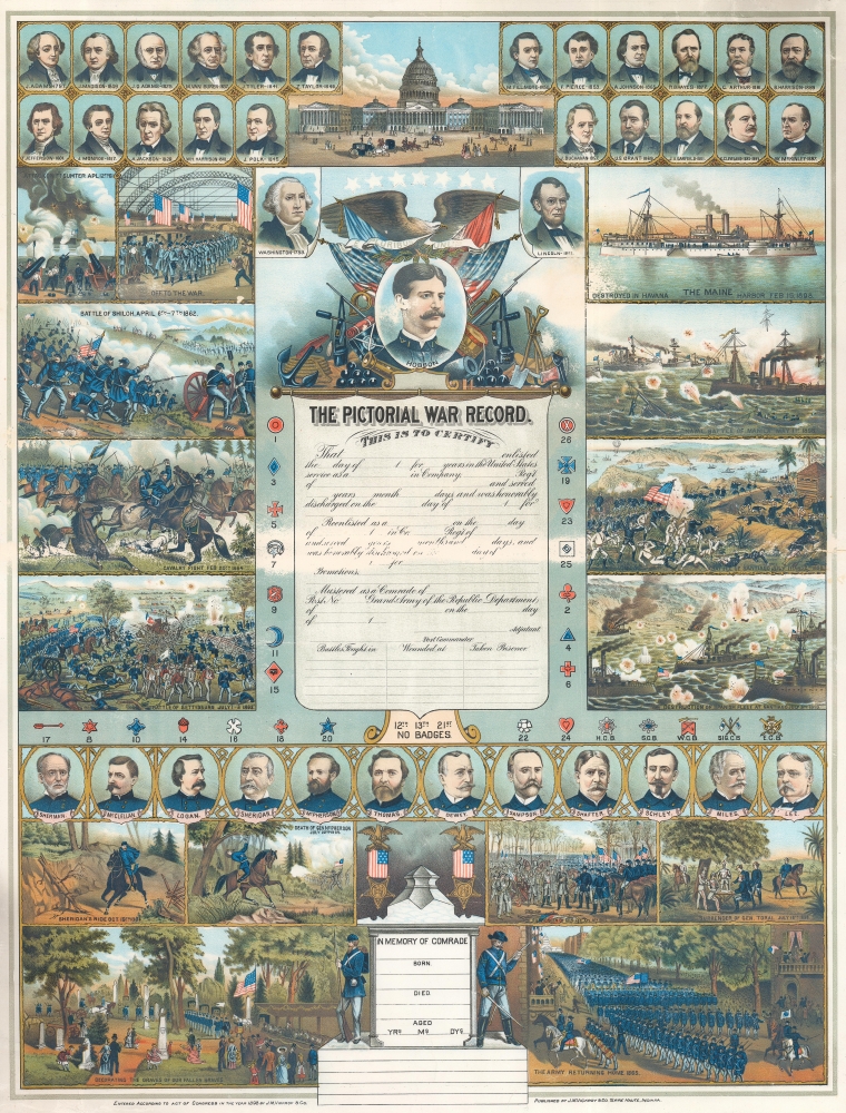

Title
The Pictorial War Record.
1898 (dated) 26 x 19.75 in (66.04 x 50.165 cm)
1898 (dated) 26 x 19.75 in (66.04 x 50.165 cm)
Description
FOR THE ORIGINAL ANTIQUE MAP, WITH HISTORICAL ANALYSIS, CLICK HERE.
Digital Map Information
Geographicus maintains an archive of high-resolution rare map scans. We scan our maps at 300 DPI or higher, with newer images being 600 DPI, (either TIFF or JPEG, depending on when the scan was done) which is most cases in suitable for enlargement and printing.
Delivery
Once you purchase our digital scan service, you will receive a download link via email - usually within seconds. Digital orders are delivered as ZIP files, an industry standard file compression protocol that any computer should be able to unpack. Some of our files are very large, and can take some time to download. Most files are saved into your computer's 'Downloads' folder. All delivery is electronic. No physical product is shipped.
Credit and Scope of Use
You can use your digial image any way you want! Our digital images are unrestricted by copyright and can be used, modified, and published freely. The textual description that accompanies the original antique map is not included in the sale of digital images and remains protected by copyright. That said, we put significant care and effort into scanning and editing these maps, and we’d appreciate a credit when possible. Should you wish to credit us, please use the following credit line:
Courtesy of Geographicus Rare Antique Maps (https://www.geographicus.com).
How Large Can I Print?
In general, at 300 DPI, you should at least be able to double the size of the actual image, more so with our 600 DPI images. So, if the original was 10 x 12 inches, you can print at 20 x 24 inches, without quality loss. If your display requirements can accommodate some loss in image quality, you can make it even larger. That being said, no quality of scan will allow you to blow up at 10 x 12 inch map to wall size without significant quality loss. For more information, it is best consult a printer or reprographics specialist.
Refunds
If the high resolution image you ordered is unavailable, we will fully refund your purchase. Otherwise, digital images scans are a service, not a tangible product, and cannot be returned or refunded once the download link is used.
Cartographer
James Monroe Vickroy (September 15, 1847 - October 14, 1913) was an American graphic artist. Born in Cumberland Valley Township, Pennsylvania, Vickroy started his professional life as a sales agent working for the M.C. Lilly Company of Columbus, Ohio, and sold ceremonial swords to secret fraternal organizations. At some point, Vickroy realized that he could take advantage of his talent as an artist and sell customized color lithographs to these fraternal orders. He married Elizabeth Enora Boor about 1875 and in 1876 the couple moved to Terre Haute, Indiana, where the first of their six daughters was born. Vickroy opened a chromolithograph business in Terre Haute in 1885, taking advantage of the at least 20 different secret societies and over 50 lodges to launch his business. He designed custom ledger books, certificates, and lithographs that he marketed to these societies, and by 1904 over 5,000 lodges used his Condensed Historical and Financial Ledger. Vickroy also designed genealogical charts, including 'The Afro-American History Record', which could be personalized. He also designed 'The Pictorial War Record', which was also meant to be personalized. More by this mapmaker...
References
Library of Congress Control Number 2018695148.