Digital Image: 1859 Daniel A. Jenks Drawing: Covered Wagons Camp Pine Grove Creek, Rocky Mountains,
PineGroveCreek-danieljenks-1859_d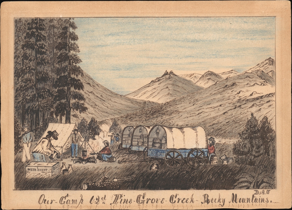

Title
Our-Camp 62d Pine-Grove-Creek Rocky Mountains.
1859 (undated) 7 x 10 in (17.78 x 25.4 cm)
1859 (undated) 7 x 10 in (17.78 x 25.4 cm)
Description
FOR THE ORIGINAL ANTIQUE MAP, WITH HISTORICAL ANALYSIS, CLICK HERE.
Digital Map Information
Geographicus maintains an archive of high-resolution rare map scans. We scan our maps at 300 DPI or higher, with newer images being 600 DPI, (either TIFF or JPEG, depending on when the scan was done) which is most cases in suitable for enlargement and printing.
Delivery
Once you purchase our digital scan service, you will receive a download link via email - usually within seconds. Digital orders are delivered as ZIP files, an industry standard file compression protocol that any computer should be able to unpack. Some of our files are very large, and can take some time to download. Most files are saved into your computer's 'Downloads' folder. All delivery is electronic. No physical product is shipped.
Credit and Scope of Use
You can use your digial image any way you want! Our digital images are unrestricted by copyright and can be used, modified, and published freely. The textual description that accompanies the original antique map is not included in the sale of digital images and remains protected by copyright. That said, we put significant care and effort into scanning and editing these maps, and we’d appreciate a credit when possible. Should you wish to credit us, please use the following credit line:
Courtesy of Geographicus Rare Antique Maps (https://www.geographicus.com).
How Large Can I Print?
In general, at 300 DPI, you should at least be able to double the size of the actual image, more so with our 600 DPI images. So, if the original was 10 x 12 inches, you can print at 20 x 24 inches, without quality loss. If your display requirements can accommodate some loss in image quality, you can make it even larger. That being said, no quality of scan will allow you to blow up at 10 x 12 inch map to wall size without significant quality loss. For more information, it is best consult a printer or reprographics specialist.
Refunds
If the high resolution image you ordered is unavailable, we will fully refund your purchase. Otherwise, digital images scans are a service, not a tangible product, and cannot be returned or refunded once the download link is used.
Cartographer
Daniel Albert Jenks (1827 - February 8, 1869) was an American gold prospector, pioneer, trader, cowboy, adventurer, artist, and diarist active in the Transmississippi from roughly 1849 to 1860. Jenks was born in Pawtucket, Rhode Island, the son of a local Baptist deacon and grocer. His is best known for his drawing and detailed journals covering over 10 years of adventuring in the American West. Jenks first went west as a Forty-Niner in search of California Gold. Having some resources and education, Jenks secured a berth on a ship around South America to San Francisco. His journals describe in detail the brutality and lawlessness of the early California gold camps. He soon became disillusioned with prospecting and attempted to settle as a merchant's clerk in Yreka, on the California-Oregon border. A restless spirit, this proved too sedate for his liking and he quickly turned back to prospecting, only to, once again, become disillusioned. Jenks returned to San Francisco in 1857, from which he embarked on the homeward journey to Pawtucket. Like many 49ers returning east, he found he could not acclimate to New England society and once again, in 1859, set out west, this time overland. He, with friends and a wagon train, struck out overland from Kansas City, first for Colorado, where he left his friends, then north into Wyoming towards California. He arrived in Yreka August 25, 1859, and returned to clerking, and again to prospecting. His health failing, in 1865, he traveled back to Rhode Island, where he died in 1869 his hometown of Pawtucket, at just 41. Today, his journals and sketches are considered among the best records of the pioneer experience in the formative years of the American West. All in all, his journals consists of five volumes. The first three, covering from 1849 - 1859, were sold by Christies in 2012 into unknown private hands, fetching some 185,000 USD. The final two volumes, capturing from 1859 - 1965, are, to our knowledge, preserved at the Pawtucket Historical Society. The Library of Congress preserves 22 of his original drawings. More by this mapmaker...