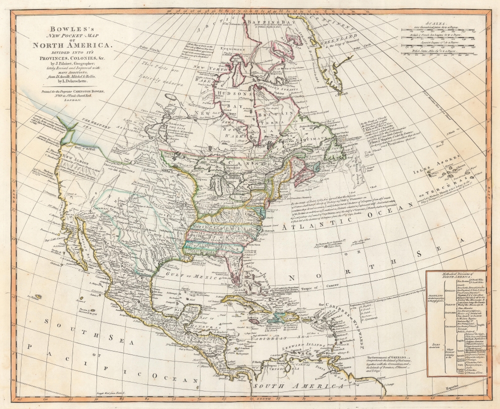
1771 Bowles Map of North America (Sea of the West)
PocketNorthAmerica-bowles-1771$2,500.00

Title
Bowles's New Pocket-Map of North America, Divided into it's Provinces, Colonies, etc,. by J. Palairet, Geographer; lately Revised and Improved with Many Additions from D'Anville, Mitchell, and Bellin, by L. Delarochette.
1771 (undated) 18.75 x 23 in (47.625 x 58.42 cm) 1 : 26928000
1771 (undated) 18.75 x 23 in (47.625 x 58.42 cm) 1 : 26928000
Description
This is a c. 1771 Carington Bowles map of North America, published just 4 years prior to the American Revolutionary War (1775 - 1783). The map depicts the increasingly complex and unstable political situation following the French and Indian War (1754 - 1763). It further illustrates ambitions for an inland Northwest Passage via Hudson Bay, and speculations about a great 'Sea of the West' dominating the Pacific Northwest - one of the last and greatest cartographic myths of the 18th century.
A Closer Look
With coverage embracing North America from Baffin's Bay south to northern South America and from the Pacific Ocean to the Azores, Bowles presents an incredibly detailed look at the continent and the West Indies. Bowles fills most of North America with detail. Native American tribes appear throughout. Cities, towns, and villages, including New York, Boston, Philadelphia, Williamsburg, and Charles Town, are labeled, along with rivers, lakes, and mountain ranges. Greenland appears near the top border.The British Colonies
Bowles illustrates the British colonies in North America in detail. Virginia, North Carolina, South Carolina, and Georgia stretch from the Atlantic Seaboard to the Mississippi, reflecting their original coast-to-coast charters. Pennsylvania and New York appear below oversized iterations of Lake Erie and Lake Ontario. Southern Florida (during the short time when East Florida it was a British possession after the Seven Years' War) appears as an archipelago. An annotation in the Atlantic details French fishing rights off the coast of Cape Breton Island as secured by treaty at the end of the French and Indian War (1754 - 1763). The Ohio River defines Virginia's northern border. Canada stretches south beyond the Great Lakes region to the confluence of the Ohio and Mississippi Rivers.Dreaming of a Northwest Passage
In northern Canada, Hudson's Bay appears in detail, with rivers, islands, and settlements illustrated. A note to the left of Hudson's Bay states 'All the Bays and Inlets on the West side of Hudson's Bay have been visited without appearance of success in the several attempt for the discovery of a Northwest Passage'. Over the preceding decades, numerous expeditions were launched to discover a Northwest Passage, long speculatively included in numerous maps of North America, but no Northwest Passage was ever found. Nonetheless, Bowles includes a suggestion of a Northwest Passage using the Port Nelson River as the gateway. This river connects with the 'L. des Forts' which in turn connects with a 'system of great lakes' in central Canada that are tantalizingly close to the speculative Sea of the West. A river heads southwest from 'L. Ouinipique' (Lake Winnipeg) and traverses what can only be the Canadian Rocky Mountains before disappearing into the area occupied by the nebulously-drawn 'Western Sea'. Intriguingly, other than the proposed system of rivers and lakes and the Western Sea, the rest of northern Canada is left blank and labeled simply as 'these parts are entirely unknown'.The Sea of the West
A magnificent inland sea appears regularly in the American Pacific Northwest on maps created in the mid to late 18th century. This massive and apocryphal body of water, generally referred to as the 'Sea of the West' or 'Mer de l'Ouest', can trace its origins to the French cartographer Guillaume De L'Isle (1675 - 1726). De L'Isle himself never published a map incorporating a 'Sea of the West' (perhaps suggesting doubt?), but a manuscript map illustrating the Sea of the West did appear in his notes. It may be that De L'Isle was inspired by a c. 1630 Thames school manuscript map, now located at Yale, that features a geographically similar body of water described as a 'Branch of the South Sea', possibly a revisionist perspective on Verrazano's Sea. The earliest printed map to include the Sea of the West was probably Jean-Baptiste Nolin’s 1742 L’Amerique ou le Nouveau Continent. It has been suggested that Nolin copied the relevant cartography from De l’Isle's manuscript, but it is more likely that information about the 'sea' verbally leaked, as Nolin's sea does not resemble De L'Isle's in any significant way. The first publication of the 'Sea of the West' a la De L'Isle appeared when Joseph Nicholas (1688 - 1768), going through his deceased elder brother's notes discovered the aforementioned manuscript map. At the time, Joseph Nicholas was working in St. Petersburg with the Tsar's Academy of Sciences. There he had access to new information absconded from the Vitus Jonassen Bering's (1681 - 1741) Great Northern Expedition. This he was keen to publish before an official map was released. In 1752, Joseph Nicholas partnered with Philippe Buache (1700 - 1773) to do just that, using Guillaume De L'Isle's posthumous notes to fill in the American side of the map. The Buache/De L'Isle map featured an accurate Siberian Arctic from Bering, but in the Americas included a monumental 'Mer d'Ouest' or bay suggestive of a viable Northwest Passage. Although De l’Isle and Buache were immediately accused of fraud, the Sea of the West appeared on many maps, with some editions even post-dating Cook.Drake's Harbor and New Albion
The 'Harbor of Sr. Francis Drake' appears along the west coast, north of what is labeled here as California. Often believed to be San Francisco Bay, Drake supposedly wintered here in 1579 and, while he was there, founded New Albion and claimed the American northwest for England.The River of the West and the Great Salt Lake
Another apocryphal feature that regularly appeared on 18th century maps, the River of the West appears here flowing almost directly westward from Pike's Lake, not far from the mythical cities of Teguayo and Quivira. This is likely a reference to the Great Salt Lake, which first appeared in western literature as Lake Timpanagos five years after this map was published. Silvestre Vélez de Escalante was a Franciscan missionary who identified the Great Salt Lake in 1776 from indigenous accounts. Since this map predates Escalante's account, Bowles must have found a reference in earlier text. In this case, it may have been that of the French explorer Baron de Lahontan. Lahontan's explorations are highly criticized as near or total fabrications, nonetheless, his work did have a significant impact on cartography. Lahontan's wonderful narrative, Nouveaux Voyages de M. le Baron de Lahontan, describes his voyage westward from the Great Lakes along the Wabash to the Mississippi. From the Mississippi he continues almost directly westward along a river he calls the 'Longue' or 'Morte' which possibly represents one of the greater Mississippi tributaries. Lahontan offers a detailed map to accompany his account showing this river - which our map shows running just to the east of Pike's Lake as the 'Mantons R'. In Lahontan's own map he divides the 'Long River' between areas that he has personally explored and regions that he has mapped from Native American descriptions. It is from these same American Indian groups that Lahontan heard tales of the Salt Lake that he describes in his narrative and that appears here.Central America and the West Indies
Cities and towns are labeled throughout Mexico and the rest of Central America. Mexico City, Vera Cruz, and Oaxaca (Guaxaca) are all labeled, along with Cozumel. Lake Nicaragua is illustrated, and Nicaragua, Honduras, Guatemala, Costa Rica, and Panama are all identified. Instead of using color to identify colonial holdings in the West Indies, Bowles uses letters to mark English ('E'), French ('F'), Dutch ('D'), Danish ('Da'), and Spanish ('S') colonies. A note also identifies the island were Columbus landed on October 11, 1492.Publication History and Census
This map was drawn by Louis Delarochette and published by Carington Bowles c. 1771. We note a single example of the present map cataloged in OCLC which is part of the collection at Université Laval in Québec. Per Stevens and Tree, the parent map for the present map was published by Jean Palairet in 1755, with four subsequent states published by the Bowles firm in 1762, 1765, and 1768, with the present 1771 edition being the fifth state.CartographerS
The Bowles Family (fl. c. 1714 - 1832) were publishers and map sellers active in London from c. 1714 to c. 1832. The firm, under Thomas Bowles (fl. 1714 - 1763), John Bowles (1701 - 1779), Carrington Bowles (1724 - 1793), and as Bowles and Carver (fl. 1794 - 1832), produced a massive corpus of work that included numerous atlases, pocket maps, and wall maps. The Bowles publishing tradition was kept alive for four generations, starting with Thomas Bowles, a print engraver active in the late 17th century. His son, Thomas Bowles II, produced the firm's first maps at St. Paul's Churchyard, London. Thomas's brother, John Bowles (a.k.a. 'Old John Bowles' or 'Black Horse Bowles'), was also an active publisher established at no. 13 Cornhill. He is credited as one of the first publishers of William Hogarth's works. There, John's son, Carrington Bowles, was introduced to the trade. Carrington took over the Cornhill bookshop and eventually merged it with his uncle's shop in St. Paul's Churchyard. On Carrington's 1793 death, the business was passed to his son Henry Carrington Bowles (1763 - 1830), who partnered with his father's former apprentice Samuel Carver (1756 - 1841), renaming the firm 'Bowles and Carver'. Under this imprint, the firm continued to publish maps and atlases until 1832. Henry Carrington Bowles died in 1830, but Samuel Carver, himself in advanced years and poor health, kept it going for another 2 years before closing the business. More by this mapmaker...
Louis Stanislaw d'Arcy Delarochette (1731 - 1802) was a British cartographer and engraver active in London, England in the late 18th century. Delarochette produced numerous maps in conjunction with various other contemporary British cartographers including Faden, Jefferys, Laurie and Whittle, Arrowsmith, and Bowles. Delarochette is perhaps best known for his monumental eight sheet map of South America, which was used to settle numerous border disputes throughout the continent. He also produced an influential map of the Cape of Good Hope, a fine map of the West Indies, and worked with Sayer and Kitchin on their A new map of North America wherein the British Dominions in the continent of North America, and on the islands of the West Indies, are carefully laid down from all the surveys, hitherto made... Learn More...
Condition
Very good. Light wear along original centerfold. Verso repairs to centerfold separations.
References
Stevens, H. and R. Tree 'Comparative Cartography' in Tooley, R.V. The Mapping of America, 56e. OCLC
1131381274.