This item has been sold, but you can get on the Waitlist to be notified if another example becomes available, or purchase a digital scan.
1762 Rizzi Zannoni Map of Poland and Lithuania
Poland2-zannoni-1762$112.50

Title
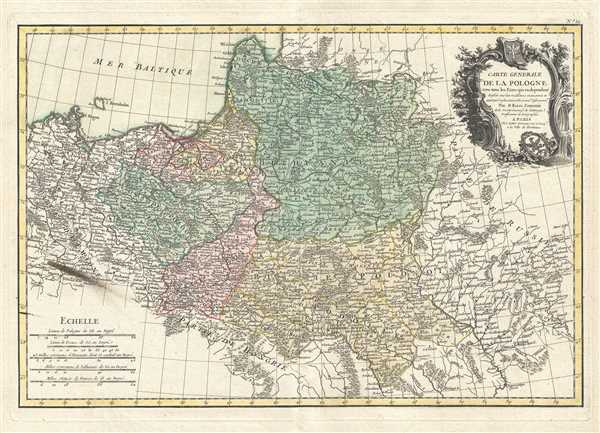
Carte Generale de la Pologne avec tous les Etats qui en dependent.
1762 (undated) 12 x 18 in (30.48 x 45.72 cm) 1 : 400000
1762 (undated) 12 x 18 in (30.48 x 45.72 cm) 1 : 400000
Description
This is a 1762 Giovanni Antonio Bartolomeo Rizzi-Zannoni map of Poland and Lithuania. The map depicts from Denmark and Germany to Russia and from Livonia to Hungary, including Lithuania, Prussia, Greater Poland, Lesser Poland, and parts of Russia, Germany, Hungary and Bohemia. Myriad towns and villages are labeled, along with rivers. Trees and hills are depicted in profile. A baroque style decorative title cartouche depicting the Polish eagle crest appears in the upper right corner.
This map illustrates Poland in the declining years of the Polish-Lithuanian Commonwealth, prior to the 1772 First Partition of the Commonwealth. In 1764, two years after this map was made, Stanislaw August Poniatowski was elevated by election to become King of Poland. This worldly and refined ruler attempted various reforms intended to preserve the failing Polish state, but found himself increasingly subservient to Tsarina Catherina II of Russia. The Bar Confederation of 1768, a rebellion against increasing Russian influence over Polish politics, led to the First Partition of the Commonwealth, a permanent annexation of Polish territory by its more powerful neighbors. Subsequent partitions in 1793 and 1795, would eventually lead to the disintegration of the Polish state, though it was later reconstituted during the Napoleonic Wars.
This map was drawn by Giovanni Antonio Bartolomeo Rizzi-Zannoni and included in Jean Lattre's Atlas Moderne.
CartographerS
Giovanni Antonio Bartolomeo Rizzi Zannoni (September 2, 1736 - May 20, 1814) was an 18th century Italian cartographer active in Venice and Naples. Zannoni was born in Padua, Italy on September 2, 1736. Between 1749 and 1751 Zannoni studied Astronomy at the University of Padua under John Polen, a prominent astronomer of the period. After leaving the University, Zannoni was commissioned by the King of Poland, Augustus III, to map that country. Zannoni's subsequent survey is considered the first accurate triangulation of Poland. Afterwards Zannoni's services were in high demand and he traveled around much of Europe, working on various surveys in Denmark, Germany, Prussia, and Sweden. Around 1757 Zannoni was caught up in the hostilities surrounding the Seven Year War and, after one battle, was taken to Paris as a prisoner of war. Paris must have suited Zannoni for he remained for nearly 20 years, even taking service with the Paris Engineer's Office. It was also here in Paris the Zannoni developed the cartographic contacts that would lead to his most prolific cartographic publications, including the Atlas Moderne in conjunction with Lattre. In 1781, Zannoni was called to Naples by the Bourbon monarchy to help in the revision of the Charter of 1769. Afterwards he stayed on and produced a numerous important maps of the Kingdom of Naples. Zannoni is considered a careful and precise cartographer and his work, particularly the maps he made in Naples, have been praised by R.V. Tooley as 'remarkable for a marvelously minute attention to detail, and amply deserves the commendation passed upon it by Sir George Fordham' (Tooley, Maps and Mapmakers, 21). Zannoni would spend the remainder of his days in Naples and passed away on May 20, 1814. More by this mapmaker...
Jean Lattré (170x - 178x) was a Paris based bookseller, engraver, globe maker, calligrapher, and map publisher active in the mid to late 18th century. Lattré published a large corpus of maps, globes, and atlases in conjunction with a number of other important French cartographic figures, including Janvier, Zannoni, Bonne and Delamarche. He is also known to have worked with other European cartographers such as William Faden of London and the Italian cartographer Santini. Map piracy and copyright violations were common in 18th century France. Paris court records indicate that Lattré brought charges against several other period map publishers, including fellow Frenchman Desnos and the Italian map engraver Zannoni, both of whom he accused of copying his work. Lattré likes trained his wife Madame Lattré (né Vérard), as an engraver, as a late 18th century trade card promotes the world of 'Lattré et son Epouse.' Lattré's offices and bookshop were located at 20 rue St. Jaques, Paris, France. Later in life he relocated to Bordeaux. Learn More...
Source
Lattre, Jean, Atlas Moderne ou Collection de Cartes sur Toutes les Parties du Globe Terrestre Par Plusieurs Auteurs, Paris, 1762.
Condition
Very good. Original platemark visible. Minor wear along original centerfold. Blank on verso. Stain lower left quadrant - see image.
References
Rumsey 2612.038. Phillips (Atlases) 664. National Maritime Museum, 215. British Library (World), col. 384-385 (1762-1785 eds.). OCLC 159801109.