1749 Vaugondy Map of Southern Portugal
PortugalSouth-vaugondy-1749$180.00

Title
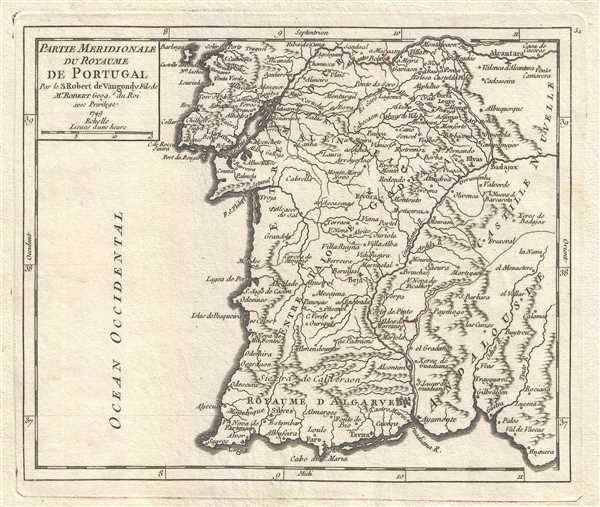
Partie Meridionale du Royaume de Portugal. Par le S. Robert de Vaugondy Fils de Mr. Robert, Geog. du Roi.
1749 (dated) 6.5 x 8 in (16.51 x 20.32 cm) 1 : 2000000
1749 (dated) 6.5 x 8 in (16.51 x 20.32 cm) 1 : 2000000
Description
This is a 1749 Vaugondy map of southern Portugal, including Lisbon (Lisbonne). The map depicts from Tagus (Tajo) River to the Atlantic Ocean and from the Atlantic Ocean to Castile and Andalousia in Spain. The Algarve region of Portugal, the southernmost region of continental Portugal, is illustrated here. The Algarve is the most popular tourist destination in Portugal and, including both foreign and Portuguese tourists, welcomes nearly 10 million visitors annually. Faro, the region's administrative center and host of the region's international airport ad public university, the University of Algarve, is labeled, located along the southern coast.
The Kingdom of Algarve (Royaume d'Algarve) was presented as a separate kingdom from that of Portugal, but it was in fact the second dominion of the Portuguese crown. The Algarvian kingdom had no institutions, special privileges or autonomy. It was just an honorific title for the Algarve region based on its history.
Numerous cities and towns are labeled, including Lisbon which sits at the mouth of the Tagus River, and several other rivers are depicted, both labeled and unlabeled. Hills and forests are depicted in profile.
This map was published by Gilles Robert de Vaugondy in his Atlas Universel, Portatif et Militaire in the 1749 edition.
Cartographer
Robert de Vaugondy (fl. c. 1716 - 1786) was French may publishing from run by brothers Gilles (1688 - 1766) and Didier (c. 1723 - 1786) Robert de Vaugondy. They were map publishers, engravers, and cartographers active in Paris during the mid-18th century. The father and son team were the inheritors to the important Nicolas Sanson (1600 - 1667) cartographic firm whose stock supplied much of their initial material. Graduating from Sanson's maps, Gilles, and more particularly Didier, began to produce their own substantial corpus. The Vaugondys were well-respected for the detail and accuracy of their maps, for which they capitalized on the resources of 18th-century Paris to compile the most accurate and fantasy-free maps possible. The Vaugondys compiled each map based on their own geographic knowledge, scholarly research, journals of contemporary explorers and missionaries, and direct astronomical observation. Moreover, unlike many cartographers of this period, they took pains to reference their sources. Nevertheless, even in 18th-century Paris, geographical knowledge was limited - especially regarding those unexplored portions of the world, including the poles, the Pacific Northwest of America, and the interiors of Africa, Australia, and South America. In these areas, the Vaugondys, like their rivals De L'Isle and Buache, must be considered speculative or positivist geographers. Speculative geography was a genre of mapmaking that evolved in Europe, particularly Paris, in the middle to late 18th century. Cartographers in this genre would fill in unknown lands with theories based on their knowledge of cartography, personal geographical theories, and often dubious primary source material gathered by explorers. This approach, which attempted to use the known to validate the unknown, naturally engendered rivalries. Vaugondy's feuds with other cartographers, most specifically Phillipe Buache, resulted in numerous conflicting papers presented before the Academie des Sciences, of which both were members. The era of speculative cartography effectively ended with the late 18th-century explorations of Captain Cook, Jean Francois de Galaup de La Perouse, and George Vancouver. After Didier died, his maps were acquired by Jean-Baptiste Fortin, who in 1787 sold them to Charles-François Delamarche (1740 - 1817). While Delamarche prospered from the Vaugondy maps, he defrauded Vaugondy's window Marie Louise Rosalie Dangy of her rightful inheritance and may even have killed her. More by this mapmaker...
Source
Robert de Vaugondy, G., Atlas Portatif, Universel, et Militaire, (Paris: Vaugondy, Durand, Pissot) 1749.
Condition
Very good. Blank on verso. Original pressmark visible. Small closed margin tears professionally repaired on verso.
References
Pedley, M. S., Bel et Utile, p. 186, 320.