This item has been sold, but you can get on the Waitlist to be notified if another example becomes available, or purchase a digital scan.
1766 Desnos and De La Tour Map of the Middle East and Arabia
PrincipauxLieux-desnos-1766$137.50

Title
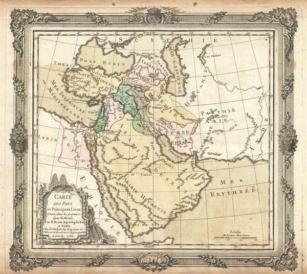
Carte des Pays et Principaux Lieux Connus dans les premiers ages du Monde.
1766 (dated) 11.5 x 13 in (29.21 x 33.02 cm) 1 : 20000000
1766 (dated) 11.5 x 13 in (29.21 x 33.02 cm) 1 : 20000000
Description
This is an appealing 1766 map of the Middle East and Arabia by Brion de la Tour and Louis Charles Desnos. It covers the regions between the Caspian Sea and the Gulf of Aden and from Turkey east to the Indus Valley including Turkey, Cyprus, Armenia, Iraq, Iran, Egypt, Saudi Arabia, Syria, etc. Political divisions are color coded. The map notes some important early places including Babylon, Media, Assyria, Mesopotamia, etc. as well as important rivers and mountains. Features Brion de la Tour's elaborate rococo border work and title cartouche. This map was prepared by Brion de la Tour and published in Louis Charles Desnos' Geographie Moderne, Historique et Politique.
CartographerS
Louis Charles Desnos (1725 - April 18, 1805) was an important 18th century instrument maker, cartographer and globe maker based in Paris, France. Desnos was born in Pont-Sainte-Maxence, Oise, France, the son of a cloth merchant. From April of 1745 he apprenticed at a metal foundry. Desnos married the widow of Nicolas Hardy, sone of the map, globe, and instrument seller Jacques Hardy. Desnos held the coveted position of Royal Globemaker to the King of Denmark, Christian VII, for which he received a stipend of 500 Livres annually. In return Desnos sent the King roughly 200 Livres worth of maps, books and atlases each year. As a publisher, Desnos produced a substantial corpus of work and is often associated with Zannoni and Louis Brion de la Tour (1756-1823). Despite or perhaps because of the sheer quantity of maps Desnos published he acquired a poor reputation among serious cartographic experts, who considered him undiscerning and unscrupulous regarding what he would and would not publish. Desnos consequently had a long history of legal battles with other Parisian cartographers and publishers of the period. It is said that he published everything set before him without regard to accuracy, veracity, or copyright law. Desnos maintained offices on Rue St. Jacques, Paris. More by this mapmaker...
Louis Brion de la Tour (1743 - 1803) was the Cartographer Royal to the King of France, his official title being Ingenieur-Geographe du Roi. Despite a prolific cartographic career and several important atlases to his name, little is actually known of his life and career. He may have been born in Bordeaux. His son of the same name was born in 1763 and published until his death in 1832. It is nearly impossible to distinguish the work of the father from the work of the son, as both used the same imprint and were active in roughly the same period. Much of their work was published in partnership Louis Charles Desnos (fl. 1750 - 1790). Their most notable work is generally regarded to be his 1766 Atlas General. Learn More...
Source
Brion de la Tour, L., Atlas General, Civil et Ecclesiastique, (Desnos, Paris) 1766.
Condition
Very good. Minor wear along original centerfold. Overall toning and some foxing. Original platemark visible.
References
OCLC: 495081017.