This item has been sold, but you can get on the Waitlist to be notified if another example becomes available, or purchase a digital scan.
1595 Ortelius Prussia: First Atlas Edition
Prussia-ortelius-1595$475.00

Title
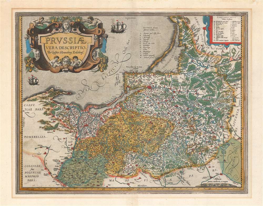
Prussiae Vera Descriptio Per Gaspar Henneberg Erlichens.
1595 (undated) 14.25 x 18.25 in (36.195 x 46.355 cm) 1 : 900000
1595 (undated) 14.25 x 18.25 in (36.195 x 46.355 cm) 1 : 900000
Description
A beautiful, original-color first atlas edition of Ortelius' third map of Prussia, added to the Theatrum Orbis Terrarum in 1595. It depicts the region now comprised of northern Poland (as far south as Toruń on the Vistula River), the Russian province of Kaliningrad, and western Lithuania. Detail spans from just west of Gdansk to Augustów in the east. The northeast limits of the map are marked with the region of Samogitia, and the Lithuanian coastal town of Palanga.
An Updated Work
Many of the maps included in early editions of the Ortelius atlas shared a sheet with other maps. For example, his 1570 map of Prussia, occupied only half of a sheet, which it shared with his map of Ditmarschen. It did not require more: its source, Heinrich Zell's 1542 work, was the first printed map of Prussia but its detail was scant in comparison to the 1576 map of Prussia by Caspar Henneberger (1529 - 1600), the source for Ortelius' 1584 full-sheet map. In 1595, Ortelius produced the present map. It contains aesthetic changes, but also amends lacunae in the place names of the 1584 and corrects several typographical errors. It is likely that Hennenberger's support from the Dukes of Prussia, in addition to his map's superior detail, brought the map to Ortelius' attention.Publication History and Census
This map was engraved for inclusion in the 1595 Latin edition of Ortelius' Theatrum Orbis Terrarum. The present example conforms typographically to that edition. A dozen examples are listed in OCLC, of various editions. This first Latin edition is cataloged in only four institutional collections.CartographerS
Abraham Ortelius (April 14, 1527 - June 28, 1598) also known as Ortels, was a cartographer, geographer, and cosmographer of Brabant, active in Antwerp. He was the creator of the first modern atlas, Theatrum Orbis Terrarum and is a seminal figure in the history of cartography. Along with Gerard Mercator and Gemma Frisius, he was a founder of the Netherlandish school of cartography. His connections with Spain - culminating in his 1575 appointment as Royal Cartographer to King Phillip II of Spain - gave him unmatched access to Spanish geographical knowledge during a crucial period of the Age of Discovery. Ortelius was born in 1527 in Antwerp. In 1547 he entered the Antwerp Guild of Saint Luke as an illuminator of maps. He began trading in books, prints, and maps, traveling regularly to the Frankfurt book and print fair, where in 1554 he met Mercator. He accompanied Mercator on journeys throughout France in 1560 and it was at this time, under Mercator's influence, that he appears to have chosen his career as a scientific geographer. His first published geographic work appeared in 1564, an eight-sheet cordiform world map. A handful of other maps preceded the 1570 publication of the first edition of the Theatrum Orbis Terrarum, which would prove to be his life work. Appearing with but 53 maps in its first edition, Ortelius' work expanded with new maps added regularly. By 1592, it had 134 maps. Many of Ortelius' maps remained the standard for nearly a century. He traveled extensively, but his genius was as a compiler, locating the best informed maps on which to base his own. His contacts throughout Europe and extending even (via the Portuguese) to the Far East were formidable. Moreover, many of his maps were based on his own scholarship, particularly his historical works. His theories of geography were particularly ahead of his time with respect to the notion of continental drift, the possibility of which he mused on as early as 1596, and which would be proven correct centuries later.
In a sense his greatest achievement was his successful navigation of the religious and political violence endemic to his city throughout his adult life: The Dutch Revolt, or Eighty Years' War (1568 - 1648), fully embroiled Antwerp. Although outwardly and officially recognized as Catholic (Arias Montanus vouched for Ortelius' Catholic orthodoxy prior to his appointment as Royal Geographer), Ortelius was able to separate himself from the religious furor which characterized the war in the low countries. Ortelius showed a glimpse of himself in a letter to a friend, regarding humanist Justus Lipsius: 'I do not know whether he is an adherent of the Pope or a Calvinist, but if he has ears to hear, he will neither be one nor the other, for sins are committed on both sides'. Ortelius' own explorations of Biblical history in his maps, and the Christogram contained in his own motto, suggest him to be a religious man, but his abjuration of political religious authorities mark him as an individualist. His tombstone at St Michael's Præmonstratensian Abbey in Antwerp bears the inscription, Quietis cultor sine lite, uxore, prole. ('served quietly, without accusation, wife, and offspring.') More by this mapmaker...
Caspar Hennenberger (1529 – February 29, 1600) was a German Lutheran pastor, historian and cartographer. He was born in Erlich, in Thüringen; he started his studies in Lutheran divinity at the University of Königsberg in 1550, and he would work for nearly thirty years as a Lutheran Pastor. His scholarship apparently reached beyond divinity, however: with the support of his patron Duke Albert of Prussia, and the aid of Prussian mathematician Nicolaus Neodomus, Hennenberger would produce, and in 1576 publish, the first detailed map of Prussia. He accompanied that work with several books amplifying on the map. Hennenberger's map would be well received: Abraham Ortelius would adopt Hennenberger's map as a model, replacing the outdated map derived from Heinrich Zell's 1542 work. Learn More...
Source
Ortelius, A., Theatrum Orbis Terrarum, (Antwerp: Plantin) 1595.
Condition
Very good. Superb original color. Some mat burn outside border, else excellent.
References
OCLC 864332867. Rumsey 10001.290 van den Broecke, M. Ortelius Atlas Maps, Ort 157.