1967 British Admiralty Nautical Chart of Doha, Qatar, Persian Gulf
QatarDoha-admiralty-1967$650.00


Title
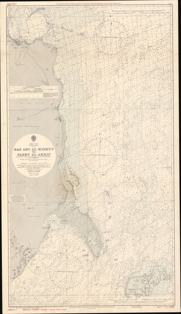
Persian Gulf Trucial Oman Ras Abu Al Mishut to Fasht Al Arrif.
1967 (dated) 50.25 x 29.34 in (127.635 x 74.5236 cm) 1 : 50000
1967 (dated) 50.25 x 29.34 in (127.635 x 74.5236 cm) 1 : 50000
Description
A scarce 1967 nautical map of the eastern part of Qatar, including Doha, focusing on the Persian Gulf coast. Coverage extends from Doha south to the Jabal An Niqyãn - thus reflecting an important shipping corridor rife with undersea dangers. The chart notes lightboats, coral reefs, and various navigational hazards. Countless depth soundings noted throughout. Limited detail inland, but the general layout of Doha is evident, as are the sites of various trees and minarets visible from the sea.
Publication History and Census
This map was first published in 1948 by the British Admiralty Hydrographic Office after the 1947 surveys of Royal Navy Captain Richard Meuric 'Sam' Southern. The map features major updates to 1952, and minor revisions to 1967. Represents Admiralty chart L(D1) 3787.Cartographer
The British Admiralty Office (1795 - Present) or the United Kingdom Hydrographic Office refers to the Branch of the English government that is responsible for the command of the British Navy. In 1795 King George III created the United Kingdom Hydrographic Office, known in short as the U.K.H.O., to provide top notch nautical charts to the vast Royal Navy. Prior the founding of the Admiralty the surveying and creation of nautical charts was primarily a commercial venture wherein the cartographer himself, more of than not, actually financed the printing of his own material. The great navigator Cook himself is known to have scrambled for funds to publish his own seminal charts - the most important and advanced of the period. The system of privately funded nautical mapping and publishing left vast portions of the world uncharted and many excellent charts unpublished. King George III, responding significant loss in trade revenue related to shipwrecks and delay due to poor charts, recognized the need for an institutionalized government sponsored cartographic agency - the Admiralty. The first head of the Admiralty, a position known as Hydrographer, was the important cartographer Alexander Dalrymple. Dalrymple started by organizing and cataloging obtainable charts before initiating the laborious process of updating them and filling in the blanks. The first official Admiralty Chart appeared in 1800 and detailed Quiberon Bay in Brittany. By 1808 the position of Hydrographer fell to Captain Thomas Hurd. Hurd advocated the sale of Admiralty charts to the general public and, by the time he retired in 1829, had issued and published some 736 charts. Stewardship of the organization then passed to Rear Admiral Sir Francis Beaufort. It was under Beaufort's administration that the Admiralty truly developed as a "chart making" as opposed to a "chart cataloging" institution. Beaufort held his post from 1829 to 1854. In his 25 years at the Admiralty Beaufort created nearly 1500 new charts and sponsored countless surveying and scientific expeditions - including the 1831 to 1836 voyage of the H.M.S. Beagle. By 1855 the Admiralty's chart catalog listed some 1,981 charts. More by this mapmaker...
Condition
Good. Stain at center. Edge and fold wear.