Digital Image: 1861 Jefferson Davis and John Pope Map of Texas: Red River to the Rio Grande
RedRiverRioGrande-johnpope-1861_d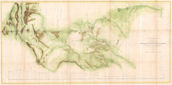

Title
Map and Profile No. 2. From the Red River to the Rio Grande; from Explorations and Surveys made under the direction of the Hon. Jefferson Davis, Secretary of War by Captain John Pope, Corps Topl. Engrs.
1861 (dated) 29 x 58 in (73.66 x 147.32 cm) 1 : 950000
1861 (dated) 29 x 58 in (73.66 x 147.32 cm) 1 : 950000
Description
FOR THE ORIGINAL ANTIQUE MAP, WITH HISTORICAL ANALYSIS, CLICK HERE.
Digital Map Information
Geographicus maintains an archive of high-resolution rare map scans. We scan our maps at 300 DPI or higher, with newer images being 600 DPI, (either TIFF or JPEG, depending on when the scan was done) which is most cases in suitable for enlargement and printing.
Delivery
Once you purchase our digital scan service, you will receive a download link via email - usually within seconds. Digital orders are delivered as ZIP files, an industry standard file compression protocol that any computer should be able to unpack. Some of our files are very large, and can take some time to download. Most files are saved into your computer's 'Downloads' folder. All delivery is electronic. No physical product is shipped.
Credit and Scope of Use
You can use your digial image any way you want! Our digital images are unrestricted by copyright and can be used, modified, and published freely. The textual description that accompanies the original antique map is not included in the sale of digital images and remains protected by copyright. That said, we put significant care and effort into scanning and editing these maps, and we’d appreciate a credit when possible. Should you wish to credit us, please use the following credit line:
Courtesy of Geographicus Rare Antique Maps (https://www.geographicus.com).
How Large Can I Print?
In general, at 300 DPI, you should at least be able to double the size of the actual image, more so with our 600 DPI images. So, if the original was 10 x 12 inches, you can print at 20 x 24 inches, without quality loss. If your display requirements can accommodate some loss in image quality, you can make it even larger. That being said, no quality of scan will allow you to blow up at 10 x 12 inch map to wall size without significant quality loss. For more information, it is best consult a printer or reprographics specialist.
Refunds
If the high resolution image you ordered is unavailable, we will fully refund your purchase. Otherwise, digital images scans are a service, not a tangible product, and cannot be returned or refunded once the download link is used.
Cartographer
John Pope (March 16, 1822 - September 23, 1892) was an American military officer active in the middle part of the 19th century. Pope was born in Louisville Kentucky to a prominent family with close ties to future president Abraham Lincoln. He graded from West Point in 1842 and served in the Mexican American War before being appointed to the Army Bureau of Topographical Engineers. He served briefly under explorer John C. Fremont, but the two never really got along. During the American Civil War, Pope, now a Major General successfully led several campaigns in the Western Theater, including the strategic capture of the fortified Mississippi River Island No. 10, near New Madrid, Missouri. He was subsequently reassigned to the Eastern Front where he was less successful ultimately suffering a disastrous defeat in the Second Battle of Bull Run. Following the Civil War, Pope served briefly as Reconstruction Governor of the Third Military District (Georgia, Florida, and Alabama) and was eventually sent west for the Apache Wars. Despite having a brash argumentative manner, he argued for humane treatment of Native Americans and campaigned against the activities of the corrupt Indian Bureau. Pope retired in 1886 and died at the Ohio Soldiers Home in Sandusky, Ohio. More by this mapmaker...
Source
Warren, K., Reports of Explorations and Surveys, to Ascertain the Most Practicable and Economical Route for a Railroad From the Mississippi River to the Pacific Ocean, (Washington: George W. Bowman) 1861.
References
Rumsey 0693.049.