Digital Image: 1858 Hind Map of the Red River Settlement, Minnesota, Saskatchewan, Manitoba
RedRiverSettlement-hind-1858_d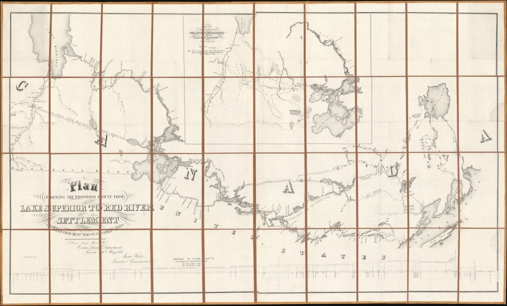


Title
Plan Shewing The Proposed Route From Lake Superior To Red River Settlement...
1858 (dated) 37.75 x 62.75 in (95.885 x 159.385 cm) 1 : 1500000
1858 (dated) 37.75 x 62.75 in (95.885 x 159.385 cm) 1 : 1500000
Description
FOR THE ORIGINAL ANTIQUE MAP, WITH HISTORICAL ANALYSIS, CLICK HERE.
Digital Map Information
Geographicus maintains an archive of high-resolution rare map scans. We scan our maps at 300 DPI or higher, with newer images being 600 DPI, (either TIFF or JPEG, depending on when the scan was done) which is most cases in suitable for enlargement and printing.
Delivery
Once you purchase our digital scan service, you will receive a download link via email - usually within seconds. Digital orders are delivered as ZIP files, an industry standard file compression protocol that any computer should be able to unpack. Some of our files are very large, and can take some time to download. Most files are saved into your computer's 'Downloads' folder. All delivery is electronic. No physical product is shipped.
Credit and Scope of Use
You can use your digial image any way you want! Our digital images are unrestricted by copyright and can be used, modified, and published freely. The textual description that accompanies the original antique map is not included in the sale of digital images and remains protected by copyright. That said, we put significant care and effort into scanning and editing these maps, and we’d appreciate a credit when possible. Should you wish to credit us, please use the following credit line:
Courtesy of Geographicus Rare Antique Maps (https://www.geographicus.com).
How Large Can I Print?
In general, at 300 DPI, you should at least be able to double the size of the actual image, more so with our 600 DPI images. So, if the original was 10 x 12 inches, you can print at 20 x 24 inches, without quality loss. If your display requirements can accommodate some loss in image quality, you can make it even larger. That being said, no quality of scan will allow you to blow up at 10 x 12 inch map to wall size without significant quality loss. For more information, it is best consult a printer or reprographics specialist.
Refunds
If the high resolution image you ordered is unavailable, we will fully refund your purchase. Otherwise, digital images scans are a service, not a tangible product, and cannot be returned or refunded once the download link is used.
Cartographer S
Henry Youle Hind (1823 - 1908) was a Canadian geologist and explorer. Born in Nottingham, England, he emigrated to Toronto in 1846. He quickly integrated with the city's scientific community, publishing works on meteorology and teaching at the University of Toronto. Hind was an early advocate of the westward expansion of Canada and the use of railways to achieve that end. His background made him a suitable candidate for two exploration expeditions in 1857-1858 that were planned with the aim of showing the suitability of the western lands (now Manitoba and Saskatchewan) for agriculture and settlement. Hind's reports on these expeditions were important in convincing the broader public in Canada, and in Britain, of the project of westward expansion. After the 1857-1858 expedition, he attempted to organize a third expedition but failed to secure government funding due to economic troubles at the time. Instead, he traveled to England to promote the reports on the 1857-1858 expeditions and was welcomed at the Royal Geographical Society. In 1861, he led a privately-financed expedition to explore Labrador. This reflected a shift in his interests towards the northeast, and he would spend the rest of his career living and working in Labrador and Nova Scotia. More by this mapmaker...
William Henry Edward Napier (1828 - 1894) was a Canadian artist, surveyor, and engineer. He was born in Montreal; his father was a secretary to Lord Elgin, of Elgin Marbles fame. He was trained as a civil engineer by Walter and Frank Shanly in Montreal and also developed his skills as an artist at this time, though his training, if any, is unknown. Napier was chosen as a surveyor for the Canadian government's 1857-1858 Red River Expedition and drew many watercolors during the expedition that were early artistic depictions of the lands of Manitoba and Saskatchewan. After the Red River Expedition, he served as the resident engineer for the Grand Trunk Railway and then worked on several engineering projects in Europe before returning to Canada in 1868 to work on the Intercolonial Railway. In 1870, he moved to Scotland and spent the rest of his life in London and Edinburgh. Learn More...
Simon James Dawson (1818 - 1902) was a Canadian engineer and politician. Born in Scotland, Dawson emigrated to Canada in his youth and was trained as an engineer. He was chosen to join the Canadian government's 1857 Red River Expedition and in 1858 - 1859 surveyed the route of a possible road and conducted explorations between Thunder Bay and Fort Garry. Afterwards, he was tasked with managing the construction of a road (a 'colonization road') along the route he had surveyed which later bore his name. Between the 1870s and 1890s, he joined the Legislative Assembly of Ontario and then the House of Commons of Canada, where he advocated for the rights of native peoples. Learn More...
Source
Hind, H. Y., Report on a Topographical and Geological Exploration of the Canoe Route Between Fort William, Lake Superior, and Fort Garry, Red River..., (Toronto: S. Derbishire and G. Desbarats) 1858.
References
Storm, Colton, A Catalogue of the Everett D. Graff Collection of Western Americana, 1894. OCLC 1016227484. Osher Map Library, G3460 1858.D4.