1858 Hind Map of the Red River Settlement, Minnesota, Saskatchewan, Manitoba
RedRiverSettlement-hind-1858$1,800.00


Title
Plan Shewing The Proposed Route From Lake Superior To Red River Settlement...
1858 (dated) 37.75 x 62.75 in (95.885 x 159.385 cm) 1 : 1500000
1858 (dated) 37.75 x 62.75 in (95.885 x 159.385 cm) 1 : 1500000
Description
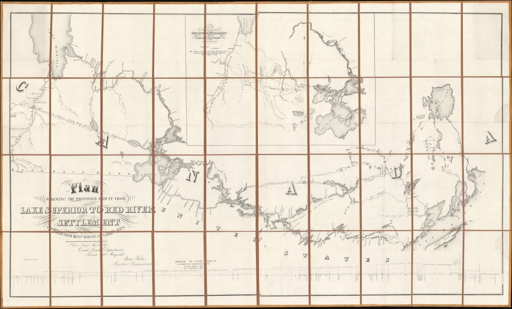
A historically significant 1858 map of the Canadian region stretching from Lake Winnipeg and the Red River Settlement to the western shores of Lake Superior. It is based on surveys by Simon James Dawson and William Napier drawn during a Canadian government-sponsored expedition undertaken the previous year and was published in Henry Youle Hind's Report on a Topographical and Geological Exploration of the Canoe Route Between Fort William, Lake Superior, and Fort Garry, Red River... The expedition's work, along with a concurrent British-financed expedition over some of the same territory, greatly stimulated interest in both London and Ottawa for Canada's westward expansion, which was realized in the following decades.
An inset map appears at top right, a reduced scale printing of Dawson's map of the area between Lake of the Woods and the Red River. Two routes to Fort Garry are displayed, one through Lac Platt that appears on the main map and a 'Proposed Line of Road,' a 'colonization road' which was constructed soon after this map's publication, with Dawson himself overseeing the work.
At bottom, Hind's 'Profile of Canoe Route' demonstrates the sometimes-abrupt changes in elevation along the route between Lake Superior and the Red River. Being a geologist, among other talents, Hind was able to indicate the types of rock and soil along the route travelled.
He initially used his wealth and estate to acquire lands in Prince Edward Island and in Upper Canada (Ontario). These lands proved insufficient, and Selkirk lobbied for more lands farther west. He reached out to the Hudson Bay Company, who had enormous territorial holdings in central and northern Canada - Rupert's Land. Although initially rebuffed, he leveraged his connections and wealth to acquire 40% of the HBC, putting them in no position to refuse. Selkirk received a grant for the entire Red River Valley, an area southwest of Lake Winnipeg nearly five times as large as Scotland, and extending into present day Minnesota and North Dakota.
This area was at the very edge of HBC holdings and was thus also the stomping ground of the rival Montreal-based North West Company. Major NWC trade routes and supply chains ran directly through Selkirk's Grant. While initially friendly with the NWC, when food ran short, the Selkirk colonists shut down exports and trade, particularly of pemmican, a frontier food staple made from dried and powdered Buffalo meat. This led to the Pemmican War (1812 - 1821), between the HBC and NWC. Fought at frontier way-stations, over rough forts, and between American Indian allies, the war lasted for nearly 10 years until the Hudson Bay and North West Companies merged in 1821 - magically putting aside past aggressions.
The Métis had well-established land claims based on residency, but few formal rights. In 1869, the Canadian Confederation negotiated to purchase Rupert's Land - including the Red River Colony - from the Hudson Bay Company. One of the first acts of the new English-speaking governor, William McDougall (1822 - 1905), was to resurvey lands under the British public survey system. At the time, most of the Métis right-of-occupancy land claims were based upon the French seigneurial colonial system, with long narrow lots fronting the river. They were moreover unsupported by documentation. The new British-style survey, with its smaller square lots and bureaucratic approach, would inevitably diminish their property rights.
The result was the Red River Rebellion, in which Métis, led by Louis Riel (1844 - 1885), captured Fort Garry, declared a new government, and put pro-Canadian settlers on trial, executing one of them. After considerable tension and threats of a wider war, a negotiated solution was brokered, allowing for Manitoba's entry into Canada as a province while maintaining certain Métis rights, in exchange for Reil's going into exile in the U.S. However, the issue remained concerning enough that immediately after this agreement was reached, the government in Ottawa sent a military expedition to occupy the region and enforce its sovereignty.
A Closer Look
Coverage ranges from Fort William on Thunder Bay, Lake Superior to Fort Garry, future Winnipeg, a Hudson Bay Company trading post at the confluence of the Red and Assiniboine Rivers. This territory includes portions of what is now Ontario and Manitoba (with part of northern Minnesota), but was then Rupert's Land, managed by the Hudson Bay Company. As waterways were the easiest means of travel, they are noted in considerable detail, including Lake Winnipeg, the Winnipeg River, Lake of the Woods, the Rainy River and Lake, Lake Superior, and many smaller lakes and rivers.An inset map appears at top right, a reduced scale printing of Dawson's map of the area between Lake of the Woods and the Red River. Two routes to Fort Garry are displayed, one through Lac Platt that appears on the main map and a 'Proposed Line of Road,' a 'colonization road' which was constructed soon after this map's publication, with Dawson himself overseeing the work.
At bottom, Hind's 'Profile of Canoe Route' demonstrates the sometimes-abrupt changes in elevation along the route between Lake Superior and the Red River. Being a geologist, among other talents, Hind was able to indicate the types of rock and soil along the route travelled.
New Selkirk or the Red River Settlement
The Red River Settlement, also known as New Selkirk, roughly corresponds with modern-day Manitoba. Thomas Douglas (1771 - 1820) unexpectedly became the 5th Earl of Selkirk in 1799. He was an unlikely heir, as his ascension to that title required the death of his father and all six brothers! Douglas was concerned with the plight of Scottish and Irish crofters then being displaced by landlords, who were reclaiming their lands for more profitable sheepherding. Selkirk determined to resettle the homeless crofters in the New World.He initially used his wealth and estate to acquire lands in Prince Edward Island and in Upper Canada (Ontario). These lands proved insufficient, and Selkirk lobbied for more lands farther west. He reached out to the Hudson Bay Company, who had enormous territorial holdings in central and northern Canada - Rupert's Land. Although initially rebuffed, he leveraged his connections and wealth to acquire 40% of the HBC, putting them in no position to refuse. Selkirk received a grant for the entire Red River Valley, an area southwest of Lake Winnipeg nearly five times as large as Scotland, and extending into present day Minnesota and North Dakota.
This area was at the very edge of HBC holdings and was thus also the stomping ground of the rival Montreal-based North West Company. Major NWC trade routes and supply chains ran directly through Selkirk's Grant. While initially friendly with the NWC, when food ran short, the Selkirk colonists shut down exports and trade, particularly of pemmican, a frontier food staple made from dried and powdered Buffalo meat. This led to the Pemmican War (1812 - 1821), between the HBC and NWC. Fought at frontier way-stations, over rough forts, and between American Indian allies, the war lasted for nearly 10 years until the Hudson Bay and North West Companies merged in 1821 - magically putting aside past aggressions.
The Métis
Over the subsequent 60 years the Red River Settlement grew, with English and French settlers intermarrying with the indigenous American Indians. The children of these unions were known as the Métis (mixed; referred to here as 'Half Breed') and became a significant demographic. Most were of French and American Indian ancestry, the scions of the generations of French fur traders. They were thus predominantly Catholic and unified in their French values.The Métis had well-established land claims based on residency, but few formal rights. In 1869, the Canadian Confederation negotiated to purchase Rupert's Land - including the Red River Colony - from the Hudson Bay Company. One of the first acts of the new English-speaking governor, William McDougall (1822 - 1905), was to resurvey lands under the British public survey system. At the time, most of the Métis right-of-occupancy land claims were based upon the French seigneurial colonial system, with long narrow lots fronting the river. They were moreover unsupported by documentation. The new British-style survey, with its smaller square lots and bureaucratic approach, would inevitably diminish their property rights.
The result was the Red River Rebellion, in which Métis, led by Louis Riel (1844 - 1885), captured Fort Garry, declared a new government, and put pro-Canadian settlers on trial, executing one of them. After considerable tension and threats of a wider war, a negotiated solution was brokered, allowing for Manitoba's entry into Canada as a province while maintaining certain Métis rights, in exchange for Reil's going into exile in the U.S. However, the issue remained concerning enough that immediately after this agreement was reached, the government in Ottawa sent a military expedition to occupy the region and enforce its sovereignty.
Publication History and Census
This map is based on the manuscript maps of Dawson and Napier and was published in Henry Youle Hind's Report on a Topographical and Geological Exploration of the Canoe Route Between Fort William, Lake Superior, and Fort Garry, Red River.... It is held by about twenty-five institutions in the OCLC, though most of those are likely not the dissected folding map presentation seen here. Hind's entire report is well-represented in institutional collections, though to an extent that is difficult to determine given the intermingling of digital, microform, and physical examples.CartographerS
Henry Youle Hind (1823 - 1908) was a Canadian geologist and explorer. Born in Nottingham, England, he emigrated to Toronto in 1846. He quickly integrated with the city's scientific community, publishing works on meteorology and teaching at the University of Toronto. Hind was an early advocate of the westward expansion of Canada and the use of railways to achieve that end. His background made him a suitable candidate for two exploration expeditions in 1857-1858 that were planned with the aim of showing the suitability of the western lands (now Manitoba and Saskatchewan) for agriculture and settlement. Hind's reports on these expeditions were important in convincing the broader public in Canada, and in Britain, of the project of westward expansion. After the 1857-1858 expedition, he attempted to organize a third expedition but failed to secure government funding due to economic troubles at the time. Instead, he traveled to England to promote the reports on the 1857-1858 expeditions and was welcomed at the Royal Geographical Society. In 1861, he led a privately-financed expedition to explore Labrador. This reflected a shift in his interests towards the northeast, and he would spend the rest of his career living and working in Labrador and Nova Scotia. More by this mapmaker...
William Henry Edward Napier (1828 - 1894) was a Canadian artist, surveyor, and engineer. He was born in Montreal; his father was a secretary to Lord Elgin, of Elgin Marbles fame. He was trained as a civil engineer by Walter and Frank Shanly in Montreal and also developed his skills as an artist at this time, though his training, if any, is unknown. Napier was chosen as a surveyor for the Canadian government's 1857-1858 Red River Expedition and drew many watercolors during the expedition that were early artistic depictions of the lands of Manitoba and Saskatchewan. After the Red River Expedition, he served as the resident engineer for the Grand Trunk Railway and then worked on several engineering projects in Europe before returning to Canada in 1868 to work on the Intercolonial Railway. In 1870, he moved to Scotland and spent the rest of his life in London and Edinburgh. Learn More...
Simon James Dawson (1818 - 1902) was a Canadian engineer and politician. Born in Scotland, Dawson emigrated to Canada in his youth and was trained as an engineer. He was chosen to join the Canadian government's 1857 Red River Expedition and in 1858 - 1859 surveyed the route of a possible road and conducted explorations between Thunder Bay and Fort Garry. Afterwards, he was tasked with managing the construction of a road (a 'colonization road') along the route he had surveyed which later bore his name. Between the 1870s and 1890s, he joined the Legislative Assembly of Ontario and then the House of Commons of Canada, where he advocated for the rights of native peoples. Learn More...
Source
Hind, H. Y., Report on a Topographical and Geological Exploration of the Canoe Route Between Fort William, Lake Superior, and Fort Garry, Red River..., (Toronto: S. Derbishire and G. Desbarats) 1858.
Condition
Very good. Dissected and laid on linen. Some infill along right border. Multiple sheets, as joined by publisher. Old handwriting on verso partially visible on recto.
References
Storm, Colton, A Catalogue of the Everett D. Graff Collection of Western Americana, 1894. OCLC 1016227484. Osher Map Library, G3460 1858.D4.