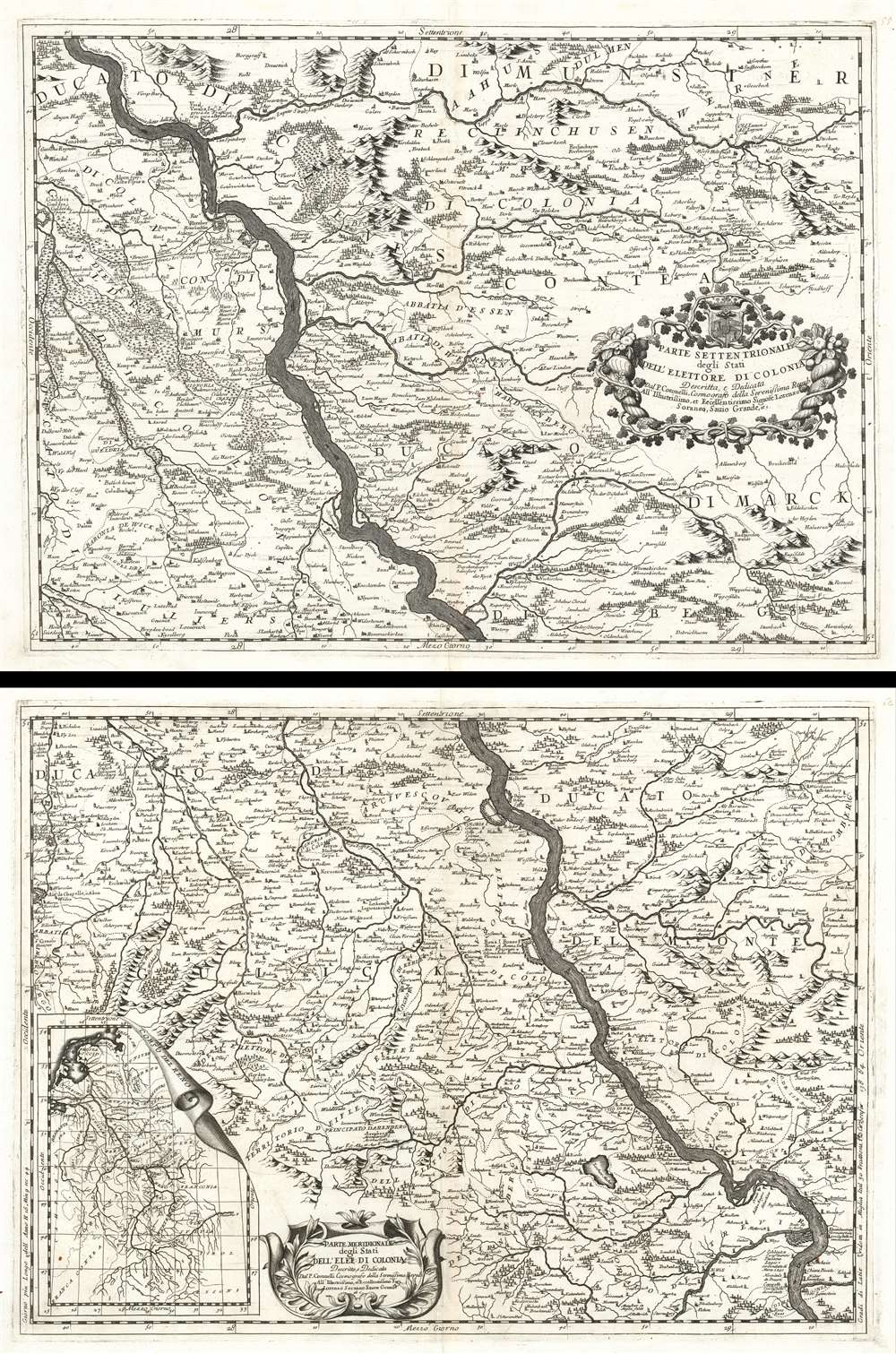
1690 Coronelli Map of the Rhine River Between Wesel and Koblenz, Germany
RhineRiver-coronelli-1690$600.00

Title
Parte Settentrionale degli Stati Dell'Elettore di Colonia. / Parte Meridionale degli Stati Dell'Elet. Di Colonia.
1690 (undated) 18.5 x 25 in (46.99 x 63.5 cm)
1690 (undated) 18.5 x 25 in (46.99 x 63.5 cm)
Description
This is a 1690 Vincenzo Maria Coronelli map of the Rhine River in northwest Germany in what was then known as the Electorate of Cologne. Presented on two sheets that can function independently, the map depicts the region along the river from Wesel to Koblenz. Numerous cities, towns, and villages are labeled along the river's course and on both sides, including Wesel, Orsoy, Cologne (Colonia), Homberg, and others. Each settlement is marked by a dot or a small collection of buildings, allowing the viewer to have some understanding of the relative size of each population center. The terrain is shown pictorially, with mountains and forests providing some idea of what the country looks like. Beautiful title cartouches are illustrated on each of the maps. An inset map of the entire course of the Rhine is situated in the bottom left corner of the lower sheet.
The Electorate of Cologne
The Electorate of Cologne was an ecclesiastical principality of the Holy Roman Empire beginning in the 10th century until the early 19th century. Based around the power of the Archbishop of Cologne, the Archbishop ruled over his temporal possessions or Hochstift as a prince-elector. Germanic tribesmen first began living at the site that became Cologne in 38 BCE, and the Romans founded Colonia Agrippina at the site in 50 AD. After nearly a millenia, Emperor Otto I of Germany appointed his brother, Bishop Bruno, as a duke, handing the archbishops of Cologne their first taste of secular power. Otto endowed his brother and his successors with the powers of secular princes. Cologne served as the capital of the electorate until 1288, when, during the Battle of Worringen, when Archbishop Siegfried of Westerberg was captured by the citizenry of Cologne and forced to declare Cologne a Free Imperial cCity to regain his freedom. After this trying experience, the archbishop fled to Bonn. Both Bonne and Cologne were occupied by France in 1794.Publication History and Census
This map was created and published by Vincenzo Coronelli in 1690. Only one example of each sheet is recorded in the OCLC and they are part of the collection of the Bibliothèque nationale de France in Paris.Cartographer
Vincenzo Maria Coronelli (August 16, 1650 - December 9, 1718) was an important 17th-century cartographer and globe maker based in Venice. Coronelli was born the fifth child of a Venetian tailor. Unlikely to inherit his father's business, he instead apprenticed in Ravenna to a woodcut artist. Around 1663, Coronelli joined the Franciscan Order and, in 1671, entered the Venetian convent of Saint Maria Gloriosa dei Frari. Coronelli excelled in the fields of cosmography, mathematics, and geography. Although his works include the phenomenal Atlante Veneto and Corso Geografico, Coronelli is best known for his globes. In 1678, Coronelli was commissioned to make his first major globes by Ranuccio II Farnese, Duke of Parma. Each superbly engraved globe was five feet in diameter. Louis IV of France, having heard of the magnificent Parma globes, invited Coronelli to Paris, where from 1681-83 he constructed an even more impressive pair of globes measuring over 12 feet in diameter and weighing 2 tons each. The globes earned him the patronage of Louis XIV and privileged access to French cartographic information from Jesuit sources in the New World, particularly Louisiana. Coronelli returned to Venice and continued to publish globes, maps, and atlases, which were admired all over Europe for their beauty, accuracy, and detail. He had a particular fascination for the Great Lakes region, and his early maps of this area were unsurpassed in accuracy for nearly 100 years after their initial publication. He is also well known for his groundbreaking publication of the first accurate map depicting the sources of the Blue Nile. At the height of his career, Coronelli founded the world's first geographical society, the Accademia Cosmografica degli Argonauti, and was awarded the official title Cosmographer of the Republic of Venice. In 1699, in recognition of his extraordinary accomplishment and scholarship, Coronelli was also appointed Father General of the Franciscan Order. The great cartographer and globe maker died in Venice at the age of 68. His extraordinary globes can be seen today at the Bibliothèque Nationale François Mitterrand in Paris, Biblioteca Marciana in Venice, the National Library of Austria, the Globe Museum in Vienna, the Library of Stift Melk, the Special Collections Library of Texas Tech University, as well as lesser works in Trier, Prague, London, and Washington D.C. Coronelli's work is notable for its distinctive style, which is characterized by the high-quality white paper, dark intense impressions, detailed renderings of topographical features in profile, and numerous cartographic innovations. More by this mapmaker...
Source
Coronelli, V., Corso Geografico Universal, (Venice: A spese dell' Autore) 1692.
The Corso Geografico Universale was a Venetian cosmographic atlas issued by the Jesuit Minorite friar, geographer, and globe maker Vincenzo Maria Coronelli. The Corso Geografico is generally dated to 1692 and is considered a follow-up to the Atlante Veneto. There is no confirmed collation of the atlas, as all editions were assembled ad-hoc. Also maps for the atlas were also sold separately, and to subscribers the rate of six cards a month for two years. The maps of the Corso Geografico are generally unique works of great historical value. They are also masterpieces of craftsmanship, engraved between 1688 and 1692 in the well-equipped cartographic workshop of the Saint Maria Gloriosa dei Frari Convent. Editions of the Corso Geografico can roughly be broken up as 68 maps 1689-92; 173 maps, 1692; 260 maps, 1694-97).
Condition
Very good. Two separate sheets. Both sheets exhibit light wear and toning along original centerfold. Both exhibit closed margin tears that have been professionally repaired on verso. Both are blank on verso.
References
OCLC 494257377. / OCLC 494257845.