This item has been sold, but you can get on the Waitlist to be notified if another example becomes available, or purchase a digital scan.
1707 Van der Aa Map of Arabia and Egypt
RoodeZeeArabien-vanderaa-1707$250.00

Title
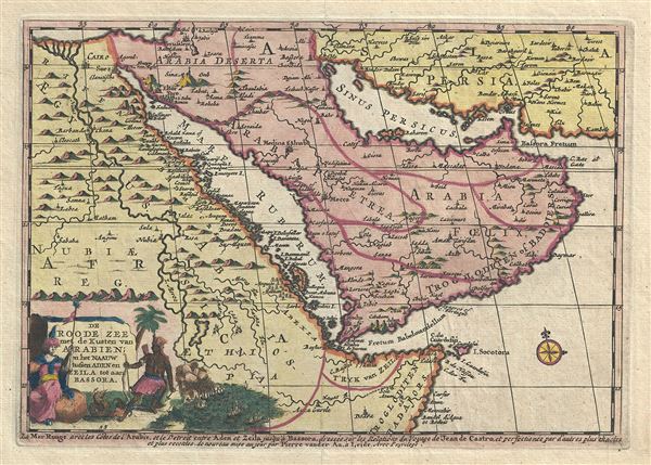
De Roode Zee met de Kusten van Arabien; en het Naauw tussen Aden en Zeila tot aan Bassora.
1707 (undated) 7 x 10 in (17.78 x 25.4 cm) 1 : 20000000
1707 (undated) 7 x 10 in (17.78 x 25.4 cm) 1 : 20000000
Description
This is a very attractive 1707 map of Arabia and Egypt by the Dutch cartographer Pieter Van der Aa. Pieter's (or Pierre) map covers from the Nile delta east as far as the Gulf of Oman and south to include much of modern day Somalia. The map is based on a sinusoidal projection, which makes Arabia look slightly distorted. This highly detailed map follows the travels of Jean de Castro, noting several cities, islands and other topographical features, with mountains beautifully rendered in profile. Mount Sinai is identified. The cities of Cairo, Mecca, Medina, etc. are also noted. Although the coastlines of the region were explored at the time, much of the interiors remain unexplored and therefore speculative. This map was originally issued in Vander Aa's Naaukeurige versameling der gedenk-waardigste Zee en land-reysen an Oost en West-Indien, this particular map was reprinted in the Atlas Nouveau. Created by Pieter Van der Aa in 1707.
Cartographer
Pieter van der Aa (1659 - 1733) was a Dutch publisher of maps and atlases active in the late 17th and early 18th centuries. Van der Aa was born in Leyden in 1659. At nine he was apprenticed to a local bookseller and, by 21, had established his own publishing, printing, and auctioneering house. In 1692 Van der Aa was appointed to be one of the High Commissioners of the Booksellers Guild. During his long and impressive career Van der Aa produced thousands of maps, including a vast 28 volume atlas containing no less than 3,000 maps. Few of Van der Aa's maps were original productions, most being copied from the work of earlier cartographers. Nonetheless, when one of Van der Aa's rare original pieces does appear, his style, with unusual projections, elegant engraving, and precise detail, is instantly recognizable and highly desirable. He also pioneered the cartographic idea of separating border artwork from the map plate itself such that every map in a collection could have a similar elaborate border without actually having to re-engrave the complex plates. This technique was used to great effect by later 18th century publishers like Brion de la Tour. Following Van der Aa's death in 1733, his much admired Nouvel Atlas was reissued by the Dutch firm of Covens & Mortier. Today Van der Aa's work is admired for its fine delicate engraving and unusual projections and is considered highly desirable among collectors. More by this mapmaker...
Condition
Very good. Minor wear along original centerfold. Minor toning and spotting. Original platemark visible.
References
Tibbetts, G. R., Arabia in Early Maps, 192.