
Van der Aa, Pieter

Pieter van der Aa (1659 - 1733) was a Dutch publisher of maps and atlases active in the late 17th and early 18th centuries. Van der Aa was born in Leyden in 1659. At nine he was apprenticed to a local bookseller and, by 21, had established his own publishing, printing, and auctioneering house. In 1692 Van der Aa was appointed to be one of the High Commissioners of the Booksellers Guild. During his long and impressive career Van der Aa produced thousands of maps, including a vast 28 volume atlas containing no less than 3,000 maps. Few of Van der Aa's maps were original productions, most being copied from the work of earlier cartographers. Nonetheless, when one of Van der Aa's rare original pieces does appear, his style, with unusual projections, elegant engraving, and precise detail, is instantly recognizable and highly desirable. He also pioneered the cartographic idea of separating border artwork from the map plate itself such that every map in a collection could have a similar elaborate border without actually having to re-engrave the complex plates. This technique was used to great effect by later 18th century publishers like Brion de la Tour. Following Van der Aa's death in 1733, his much admired Nouvel Atlas was reissued by the Dutch firm of Covens & Mortier. Today Van der Aa's work is admired for its fine delicate engraving and unusual projections and is considered highly desirable among collectors.
Elegantly Composed Double Hemisphere World Map.
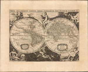
Nova Delineatio Totius Orbis Terrarum Per Petrum Vander Aa.
$1,750.00
Acquire
- Digital Map Information
- Suitable for large format printing
- File Size: 15.01 MB
- File Type: ZIP / TIFF
- ICC color profile embedded
- Delivered instantly via download link
This elegant double-hemisphere map of the world, engraved in 1660 by Jacob van Meurs, encapsulates the European understanding of the world during the second part of the 17th century. It is notable as well for its stately decorative imagery. (more details)
Baroque Masterpiece in the Scientific Mapping of The World.
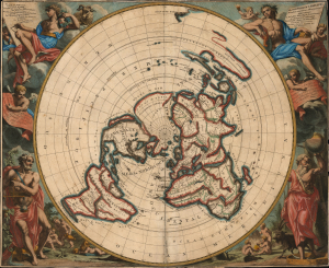
Planisphere terrestre: suivant les nouvelles observations des astronomes.../ Planispherium terrestre: secundum recentiores astronomorum observationes...
$4,250.00
Acquire
- Digital Map Information
- Suitable for large format printing
- File Size: 34.28 MB
- File Type: ZIP / TIFF
- ICC color profile embedded
- Delivered instantly via download link
This beautiful north polar projection map of the world, published in 1713 by Pieter van der Aa, is the most attractive depiction of a lost cartographic monument: Giovanni Domenico Cassini's eight-meter world map, which at one time adorned the floor of the Paris Observatory. That mammoth work can be considered the earliest scientific map of the world: it was the first to fix longitude based upon accurate astronomical observation. The present map is a glorious work of baroque art, embellished by the masterful decorative engravings of Gilliam van der Gouwen, based on the drawings of Jan Goeree. (more details)
Fine engraving and an unusual projection.
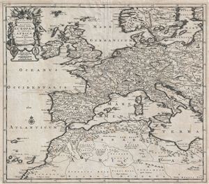
Tabula Geographica quae Continet Totam Fere Europam et Proxima Africae In usum Historiae Recentioris.
$600.00
Acquire
- Digital Map Information
- Suitable for large format printing
- DPI: 300
- File Size: 12.75 MB
- File Type: ZIP / TIFF
- ICC color profile embedded
- Delivered instantly via download link
An appealing 1710 map of europe and northern Africa by the Dutch map publisher Pieter Van der Aa. The map covers all of continental europe as well as the British Isles and parts of adjacent Scandinavia and Northern Africa, specifically the Maghreb or Barbary ... (more details)
Nexus of Central Switzerland.
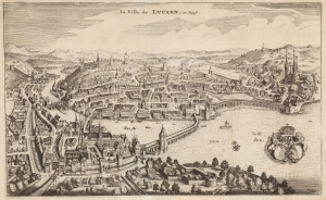
La Ville de Lucern, en Suisse.
$250.00
Acquire
- Digital Map Information
- Suitable for large format printing
- DPI: 600
- File Size: 19.02 MB
- File Type: ZIP / TIFF
- ICC color profile embedded
- Delivered instantly via download link
This is Pieter van der Aa's 1723 bird's eye view of Luzern (Lucerne), Switzerland. The city is viewed from the south, at the mouth of the Reuss River at the west end of Lake Lucerne. The town's unique array of bridges made this a favorite perspective. Matthas Merian had chosen it in 1642, and Van der Aa has copied it faithfully down to the elaborate city coat of arms in the lower right. (more details)
A rare, incredibly detailed, and meticulously engraved view of Syracuse.
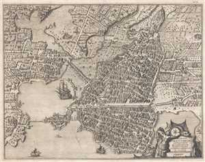
Delineatio Syracusarum Antiquarum Quadriurbium.
$600.00
Acquire
- Digital Map Information
- Suitable for large format printing
- DPI: 300
- File Size: 9.82 MB
- File Type: ZIP / TIFF
- ICC color profile embedded
- Delivered instantly via download link
This is a rare and beautifully engraved 1725 Pieter van der Aa view of Syracuse, Italy. Oriented toward the west, the view depicts the entire city in incredible detail, with individual buildings, walls, and streets illustrated throughout. Nearly 200 locations ... (more details)
Rare Singapore Map! Only 100 known to have been printed.
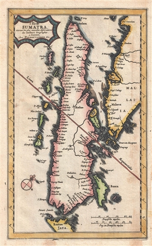
L'Ile de Sumatra suivant les plus nouvelles observations des meilleurs geographes.
$650.00
Acquire
- Digital Map Information
- Suitable for large format printing
- DPI: 300
- File Size: 1.98 MB
- File Type: ZIP / TIFF
- ICC color profile embedded
- Delivered instantly via download link
An exceptional and scarce 1727 Pieter van der Aa map of Sumatra, the Strait of Malacca, Singapore, and the southern part of the Malaya Peninsula. Taking full advantage of the small paper size, this map is oriented to the northwest with Sumatra presented ... (more details)