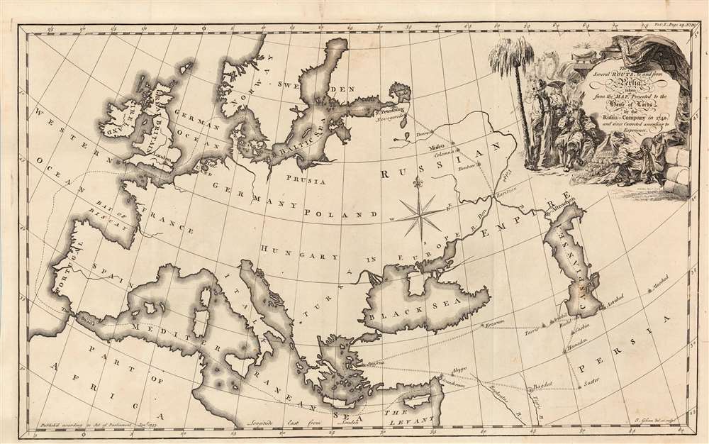
1762 Jonas Hanway Map of Europe with Trade Routes to Persia
RoutesPersia-gibson-1753$450.00

Title
The Several Routs, to and from Persia taken from the Map, presented to the House of Lords by the Russia Company in 1740 and since Corrected according to Experience.
1753 (dated) 13 x 21.5 in (33.02 x 54.61 cm) 1 : 7133650
1753 (dated) 13 x 21.5 in (33.02 x 54.61 cm) 1 : 7133650
Description
This elegant 1753 Jonas Hanway map of Europe and the Near East illustrates the trade routes of British Russia Company, as proposed to the House of Lords in 1740. It was engraved in 1753 by John Gibson to accompany Jonas Hanway's account of his journey from Russia to Persia. Although not himself a company member, the merchant Hanway entered into partnership with member Robert Dingley (1710 - 1780). Thus, Hanway's routes taken in his 1743 journey hewed closely to the northern one proposed here. This route ran by sea to St. Petersburg and then by land to Tsaritsyn, Astrakhan and the Caspian Region. A southern route was also presented, from London via the Mediterranean to Syrma, and then to Persia via Asia Minor.
The Russia Company
Overshadowed by the sprawling British East India Company, the Russia Company was an extremely successful but surprisingly obscure mid-18th century joint-stock trading venture. Despite its imports into Britain rivaling those of the East India Company, the obscurity of its membership and political influence have led to the Company being ill understood by historians. The trade venture was fruitful: for example, Jonas Hanway made his fortune in partnership with Russia Company member Robert Dingley, thereafter exercising his wealth as a philanthropist. But the Company also furthered Britains strategic interests both in the Baltic, and began laying the foundations for the extension of British power in Central Asia.Elegantly Presented
Gibson's engraving is beautifully executed, embellished with a fine compass rose and a dramatic, exotic cartouche, showing European merchants conversing with an Eastern potentate seated beside bales of silks.Publication History and Census
The map was engraved by John Gibson in 1753 for inclusion in Jonas Hanway's An Historical Account of the British Trade over the Caspian Sea. We are aware of three editions of the work; this example appeared in the third. It is distinguishable from the early editions only by the typeset pagination in the upper border. We see eight examples of the complete work in institutional collections. We see only two examples of this map catalogued in OCLC, in the 1753 and 1754 issues respectively, at the National Libraries of Israel and Scotland.CartographerS
Jonas Hanway (August 12, 1712 - September 5, 1786), was an English philanthropist, traveller, and writer. He was apprenticed in 1729 to a merchant in Lisbon, but in 1743 he became partner to merchant and member of the British Russia Company Robert Dingley (1710 - 1780) who was based in St. Petersburg. This led to the travels in Russia, Central Asia, and Persia which would inform Hanway's (copious) writing on the topic of British trade in the Caspian Sea, which would earn him the attentions of scholar Charles Wilson who hailed him 'one of the most indefatigable and splendid bores of English history.' On his return to London his narrative brought him some fame and success, and thereafter he remained in the city devoted to good causes and good citizenship. He founded The Marine Society in 1756 (a charity supporting inland youths wishing to go to sea.) He was instrumental in the aid of various hospitals; arranged improvements in Londons's birth registration system; and in 1762 he was appointed a commissioner for victualling the navy. Hanway was an eccentric and a gadfly. He protested, voluminously, the English practice of tea drinking, both on the grounds of its effect on the health and on the balance of foreign trade. He was the first male Londoner to carry an umbrella. This shocking move drew the opprobrium of fellow Londoners who objected to the effeminate, French contraption, and the ire of hansom cab drivers who quite correctly identified the invention as a threat to their trade (rainstorms caused Londoners to flock to hansom cabs as a sheltered means of transport.) He died unmarried. A monument to his memory stands in Westminster Abbey, praising his works of charity. It discusses neither umbrellas nor tea. More by this mapmaker...
John Gibson (1724 – 1773) was an English map engraver active in London at the end of the 18th century. Gibson was the son of a locksmith. In 1739 he apprenticed to John Blundell as a stationer of Grub Street. Gibson proved a fine engraver and was much in demand by London map publishers. During his career he produced thousands of maps and was admired as a skilled engraver and sculptor. Among others, he engraved for Emanuel Bowen, Robert Sayer, Jean Palairet, John Rocque, Andrew Dury, and Benjamin Martin. His best known work was prepared in conjunction with Gentleman's Magazine. Gibson, sadly, was not as astute in his fiscal affairs as with the engravers pen and consequently spent much of his life consigned to debtor's prison. Learn More...
Source
Hanway, Jonas, An Historical Account of the British Trade over the Caspian Sea with the Author's Journal of Travels from England through Russia into Persia; and back through Russia, Germany and Holland, (London) 3rd Edition, 1762.
Condition
Very good. Faint offsetting, margin reinstated at insertion point.
References
OCLC 999694916 (1753).