This copy is copyright protected.
Copyright © 2024 Geographicus Rare Antique Maps
1890 Shawe Map of the Rovuma and Zambesi Rivers, Southeast Africa
RovumaZambesiRivers-shawe-1890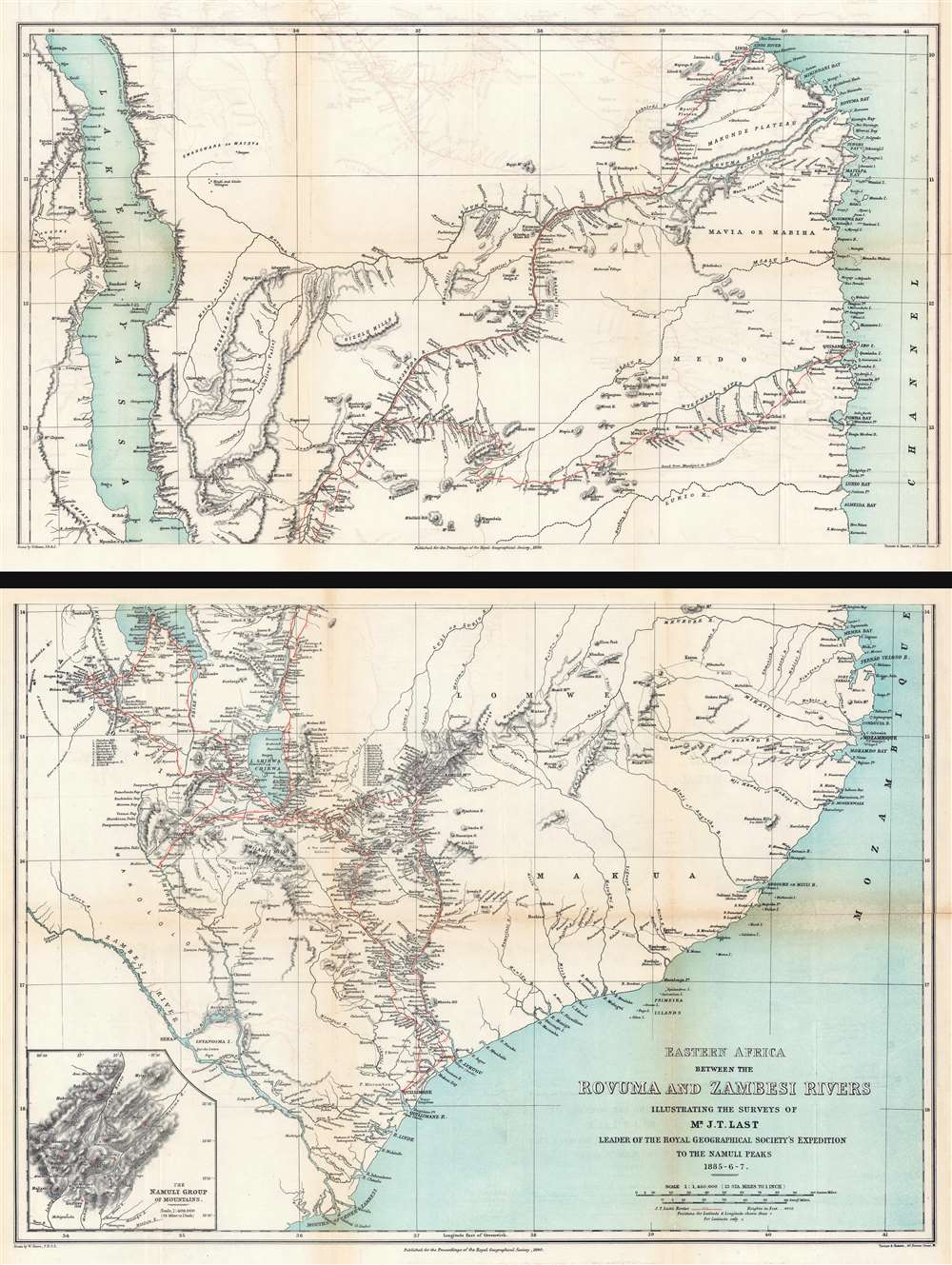
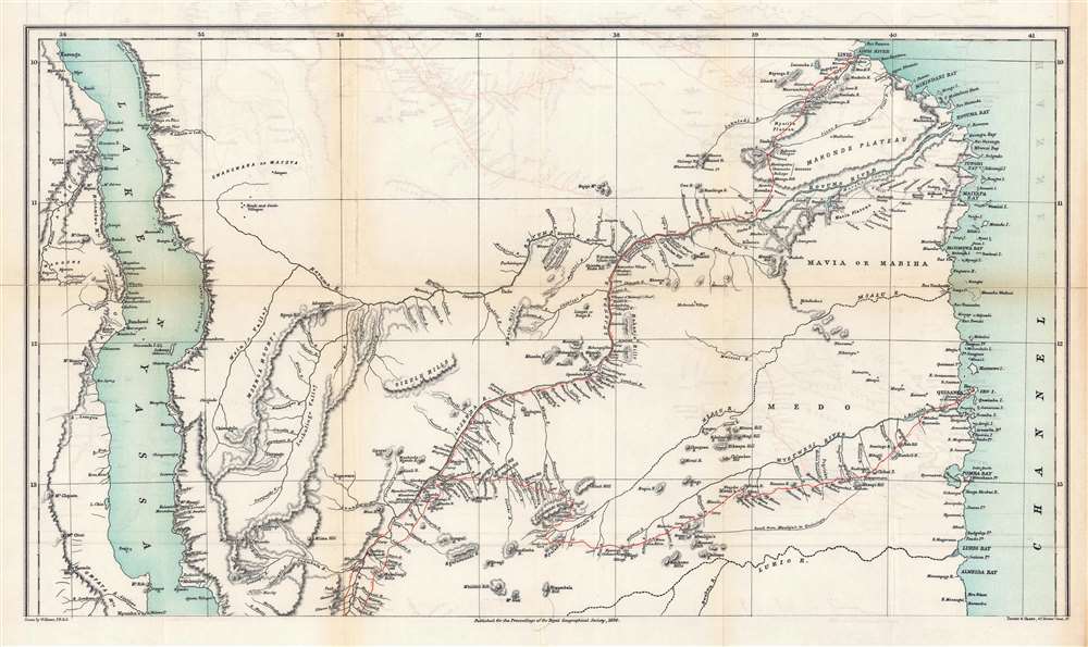
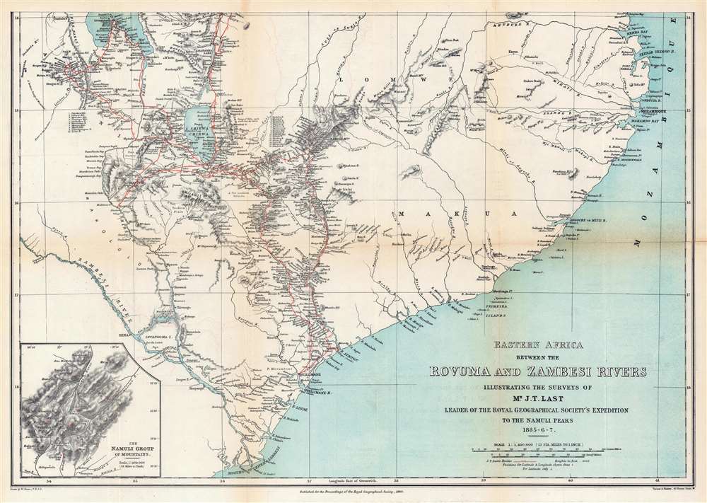
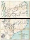
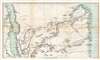
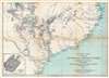

The chief objects of the expedition, as stated in the instructions given to Mr. Last, were to make a survey of the Namuli Peaks, and to study the climate and economic products of the district, and the character and languages of the native tribes. He was also to determine by accurate observations the position of the junction of the Lujenda and Rovuma, and in traveling thence to the Namuli Hills, to take the hitherto unexplored native caravan route through the Medo country, visiting also the Mavia people, and, if he visited Lake Shirwa and the Scottish Mission station of Blantyre, he was to connect his survey with that of Mr. Consul O'Neil. Finally, he was to return to the coast by way of the Lukuga Valley, and thence proceed to Mozambique.The British never formally invaded Portuguese East Africa - maybe Last found little to recommend it? - but British merchants and business people from nearby Rhodesia and South Africa were increasingly active in the region in the late 19th and early 20th centuries.
Royal Geographical Society (fl. 1830 - present) is a British Society established in 1830 to promote geographical science and exploration. Originally titled the "Geographical Society of London", the RGS received its royal charter from Queen Victoria in 1859 shortly after absorbing several similar but more regional societies including the African Association, the Raleigh Club and the Palestine Association. The RGS sponsored many of the most important and exciting voyages of exploration ever undertaken, including the exploration of Charles Darwin, David Livingstone, Robert Falcon Scott, Richard F. Burton, John Speke, George Hayward, H. M Stanley, Ernest Shackleton and Sir Edmond Hillary. Today, the RGS remains a leading global sponsor of geographical and scientific studies. The Society is based in Lowther Lodge, South Kensington, London. More by this mapmaker...
Joseph Thomas Last (December 25, 1848 - December 13, 1933) was an English missionary, naturalist, and explorer. Born in Tuddenham, Suffolk, Last was ordained at the Church Missionary College in 1872. He set out for East Africa for the first time in October 1874 and established a mission at Kisulutini, East Equatorial Africa. He returned to Britain in 1876 for unknown reasons before being sent back in November 1877. He was then appointed to the Usagara Mission in Mpwapwa, and in 1880 went on to found a new mission in the Nguru Mountains at Mamboya. He returned to Britain in December 1884 after living in Africa for seven years. Shortly thereafter, in 1885, he was engaged by the Royal Geographical Society to explore the Namuli Mountains. That expedition lasted until April 1887. In 1897, he was appointed Commissioner of Slavery for the Island of Zanzibar. He married his first wife, Annie Jackson, in September 1880. Jackson joined him in Africa and became the first European woman to reside at the Nyanza Mission. Jackson died in 1883. At some point Last remarried, although it is unknown when. Last died in 1933 and is remembered as 'a man of robust and virile personality' who possessed 'an unrivalled knowledge of Swahili'. He is also remembered for his contributions to conchology, having collected countless specimens in his travels, some of which have never been recollected. Learn More...
Copyright © 2024 Geographicus Rare Antique Maps | Geographicus Rare Antique Maps
This copy is copyright protected.
Copyright © 2024 Geographicus Rare Antique Maps