1817 Thomson Map of Eastern Europe, Ukraine, Russia, Baltic States
RussiaEuropean-thomson-1815-2$350.00

Title
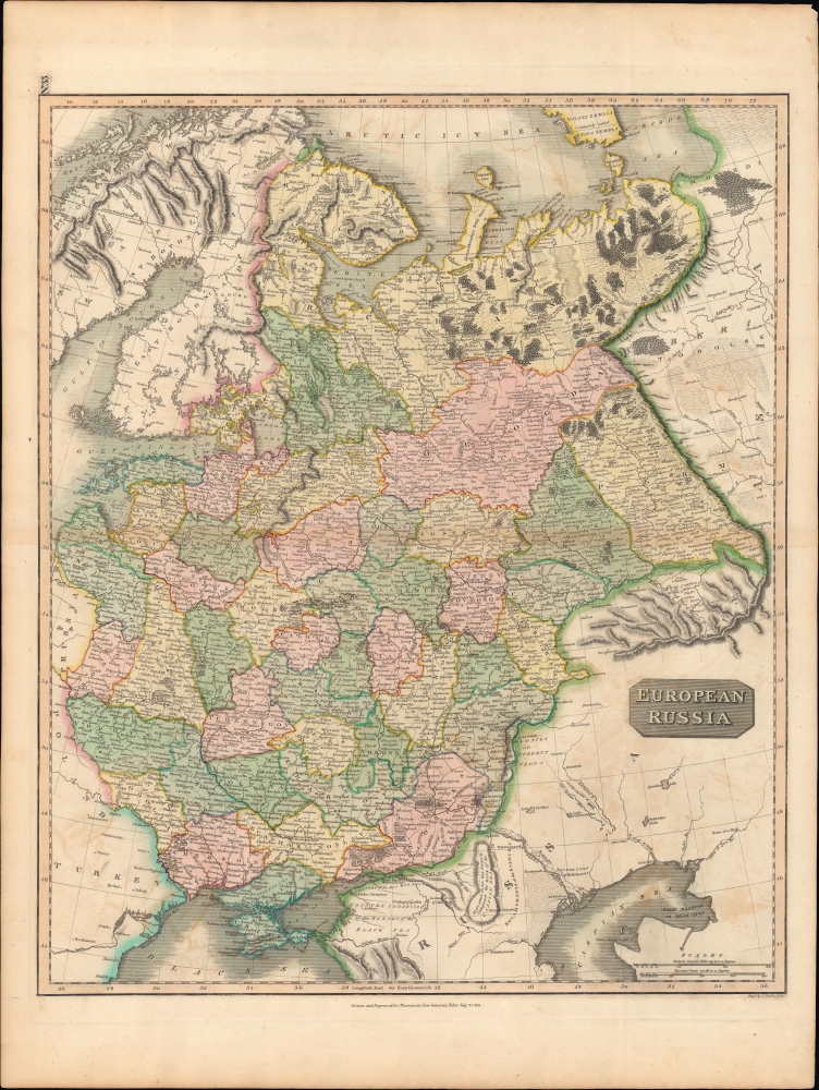
European Russia.
1815 (dated) 23.5 x 19.5 in (59.69 x 49.53 cm) 1 : 5200000
1815 (dated) 23.5 x 19.5 in (59.69 x 49.53 cm) 1 : 5200000
Description
An impressive 1815 John Thomson map of the European part of the Russian Empire, beautifully engraved by Moffat. It was produced in the wake of the Napoleonic Wars and the Congress of Vienna, where Russia announced itself as one of the major players in Europe and the political map of Europe was remade.
Lovely hand-coloring distinguishes governorates of the Russian Empire. Towns and cities are noted throughout, including in neighboring territories beyond the empire's borders. Mountains, rivers, lakes, forests, and other geographical features are also indicated. Text provides further explanation, especially along Russia's frontier, such as south of the River Don, below and to the left of the title.
This map is superficially very similar to one of the same title and intended for the same publication, but dated November 30, 1815 (previously sold by us) instead of July 21, 1815. Due to the use of the same hand-coloring scheme to distinguish territories, the two appear identical at a glance, but a closer examination reveals important differences. To begin with, the later map was engraved by Neele instead of Moffat. Also, the present map is numbered 33 at top-left, while the Neele engraving is unnumbered. Neele removed Moffat's illustrations of forests and reworked his mountains to make them less prominent. He also added roads, instituted a system of illustrations for settlements to indicate their size and function, and made some changes to update territories and geographical features. In other words, it was a map that emphasized information and functionality, while the present map leaned more towards aesthetics.
The similarity of these two maps and their both being dated 1815 complicates any census. The OCLC notes the map being cataloged at twelve institutions, but it is likely that most of those are from the issue of the atlas with Neele's engraving.
A Closer Look
Ranging from the Baltic states (then controlled by Russia), Prussia, Poland (what remained of it), Romania, and Moldovia to the Urals, this map takes in the European portion of the Russian Empire. Much of this territory had been conquered by the Russian state in the preceding 150 years, particularly under Peter the Great and Catherine the Great.Lovely hand-coloring distinguishes governorates of the Russian Empire. Towns and cities are noted throughout, including in neighboring territories beyond the empire's borders. Mountains, rivers, lakes, forests, and other geographical features are also indicated. Text provides further explanation, especially along Russia's frontier, such as south of the River Don, below and to the left of the title.
Historical Context
In 1815, Russia was in a commanding position in eastern Europe. Due to its critical role in defeating Napoleon, the Russians could make ambitious demands at the Congress of Vienna. But pushback from other victorious nations led to a delicate balance of power and a carving up of territory (i.e. Poland) between Prussia, Austria, and Russia. With the path to further inroads into central Europe seemingly blocked, and in order to shore up Russia's economic and fiscal position, the Tsars began an aggressive series of expansions into the Caucuses and Central Asia that would vastly increase the landmass of the Russian Empire.Publication History and Census
This map was engraved in 1815 by J. Moffat in Edinburgh for the 1817 edition of Thomson's New General Atlas. It differs from most other maps in the atlas, which list John Menzies or Samuel John Neele as engraver. The individual listed here appears distinct from James Moffat, another Scottish engraver from Edinburgh, who spent most of his life in India and was known for his prints of daily life in Calcutta.This map is superficially very similar to one of the same title and intended for the same publication, but dated November 30, 1815 (previously sold by us) instead of July 21, 1815. Due to the use of the same hand-coloring scheme to distinguish territories, the two appear identical at a glance, but a closer examination reveals important differences. To begin with, the later map was engraved by Neele instead of Moffat. Also, the present map is numbered 33 at top-left, while the Neele engraving is unnumbered. Neele removed Moffat's illustrations of forests and reworked his mountains to make them less prominent. He also added roads, instituted a system of illustrations for settlements to indicate their size and function, and made some changes to update territories and geographical features. In other words, it was a map that emphasized information and functionality, while the present map leaned more towards aesthetics.
The similarity of these two maps and their both being dated 1815 complicates any census. The OCLC notes the map being cataloged at twelve institutions, but it is likely that most of those are from the issue of the atlas with Neele's engraving.
Cartographer
John Thomson (1777 - c. 1841) was a Scottish cartographer, publisher, and bookbinder active in Edinburgh during the early part of the 19th century. Thomson apprenticed under Edinburgh bookbinder Robert Alison. After his apprenticeship, he briefly went into business with Abraham Thomson. Later, the two parted ways, John Thomson segueing into maps and Abraham Thomson taking over the bookbinding portion of the business. Thomson is generally one of the leading publishers in the Edinburgh school of cartography, which flourished from roughly 1800 to 1830. Thomson and his contemporaries (Pinkerton and Cary) redefined European cartography by abandoning typical 18th-century decorative elements such as elaborate title cartouches and fantastic beasts in favor of detail and accuracy. Thomson's principle works include Thomson's New General Atlas, published from 1814 to 1821, the New Classical and Historical Atlas of 1829, and his 1830 Atlas of Scotland. The Atlas of Scotland, a work of groundbreaking detail and dedication, would eventually bankrupt the Thomson firm in 1830, at which time their plates were sequestered by the court. The firm partially recovered in the subsequent year, allowing Thomson to reclaim his printing plates in 1831, but filed again for bankruptcy in 1835, at which time most of his printing plates were sold to A. K. Johnston and Company. There is some suggestion that he continued to work as a bookbinder until 1841. Today, Thomson maps are becoming increasingly rare as they are highly admired for their impressive size, vivid hand coloration, and superb detail. More by this mapmaker...
Source
Thomson, J., A New General Atlas, (Edinburgh: Baldwin, Cradock, Joy) 1817.
Thomson's New General Atlas was first published in 1817 and continued to be published until about 1821. This is the first of Thomson's major cartographic works and the atlas for which is most celebrated. The New General Atlas follows in the Edinburgh School, which eschews excessive decoration in favor of a more minimalistic fact-based cartographic vision, as established by John Pinkerton, Laurie and Whittle, John Cary, and others in the previous decades. The maps are notable for their massive scale, heavy stock, elegant color work, and easy-to-read typefaces. Although the atlas stopped being published after 1821, Thomson continued to offer 'supplementary' maps that could be tipped into the atlas as late as 1830, when he declared bankruptcy. The maps in the Thomson Atlas were engraved by Thomas Clerk, William Dassauville, Nathaniel Rogers Hewitt, James Kirkwood, Robert Kirkwood, John Menzies, George Menzies, Edward Mitchell, John Moffatt, Samuel John Neele, Robert Scott, and James Wyld.
Condition
Very good. Some centerfold discoloration.
References
Rumsey 1007.034. OCLC 899851358, 30757644, 730049976.