This item has been sold, but you can get on the Waitlist to be notified if another example becomes available, or purchase a digital scan.
1881 Wheeler Geological Map of Northern New Mexico, Southern Colorado
SCOnNM-wheeler-1881$175.00

Title
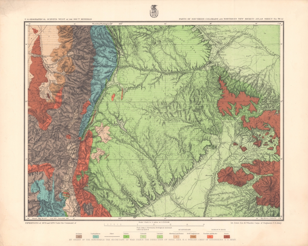
Parts of Southern Colorado and Northern New Mexico - Atlas Sheet No. 70 (A).
1881 (dated) 18 x 20 in (45.72 x 50.8 cm) 1 : 253440
1881 (dated) 18 x 20 in (45.72 x 50.8 cm) 1 : 253440
Description
A brightly-colored chromolithograph geological map of lands along the New Mexico - Colorado border produced by the Wheeler Survey and published in the Topographical Atlas which summarized the survey's work. In addition to geological information, it reflects the growing settlement and infrastructure in the region, especially post offices and railroads.
The 1877 edition of this map is cataloged among the holdings of the University of Wisconsin - Milwaukee, the Museum of New Mexico Library, and the Autry Museum of the American West, while the present 1881 edition is held by the University of Wisconsin - Milwaukee, the Museum of New Mexico Library, the University of Nevada, Las Vegas, the University of Texas at Arlington, and the Sorbonne Université.
A Closer Look
Largely overlapping with Las Animas County, Colorado, and Colfax County, New Mexico, this map uses bold colors and lines to indicate various rock types and geologic eras. Additionally, great attention is paid to topography (demonstrated with hachures), with peaks and other features noted with their elevations. Waterways, towns, post offices, roads, and railroads are also included. Notably, the Atchison, Topeka, and Santa Fe Railroad is prominent at right, and intersects with the Denver and Rio Grande at top-right, at El Moro. Raton, at center-right, nowadays the largest town on the New Mexico side of the border, was founded at the site of Willow Springs (also labeled), an established stop on the Santa Fe Trail. On the Colorado side of the border, the largest town was and remains Trinidad, along the Purgatoire (here as Purgatory) River.The Maxwell Land Grant
Much of this land was part of the Maxwell Land Grant (named for Lucien B. Maxwell), also known as the Beaubien-Miranda Land Grant, originally a Mexican Land Grant that became one of the largest private landholdings in the United States following the Mexican-American War. The changeover from Mexican to U.S. administration caused a change in legal regime and, combined with poor surveying and demarcation, resulted in land disputes which could turn violent. These confrontations only worsened when Maxwell sold the land grant to European investors in 1870, supercharging the influx of miners, ranchers, and farmers, in turn increasing violent land disputes, as with the Colfax County War and an 1888 confrontation at Stonewall Gap (here as Stonewall Post Office). The rapid infusion of people and money into the region led to the rise of boom towns, which shrank drastically or even became ghost towns after mines and other natural resources were exhausted in the early 20th century.The Wheeler Survey, 1872 - 1879
One of the 'Four Great Surveys' of the American West, the expedition led by U.S. Army officer George Montague Wheeler was tasked with creating geologic and topographic maps of the territory west of the 100th meridian at the scale of eight miles to one inch. Like the other three 'great surveys' that took place around the same time, led by Clarence King (Fortieth Parallel Survey), John Wesley Powell (Green and Colorado Rivers, including the Grand Canyon), and Ferdinand Vandeveer Hayden (U.S. Geological and Geographical Survey of the Territories, focusing on the Yellowstone Region), the Wheeler Survey collected a wide range of information on Native American cultures (including early photographs), flora, fauna, and other topics in addition to its surveying work. Veterans of these expeditions went on to illustrious careers in the military, geology, cartography, photography, painting, and other fields. In 1879, Congress formally merged these projects to create the U.S. Geological Survey.Chromolithography
Chromolithography, sometimes called oleography, is a color lithographic technique developed in the mid-19th century. The process involved using multiple lithographic stones, one for each color, to yield a rich composite effect. Oftentimes, the process would start with a black basecoat upon which subsequent colors were layered. Some chromolithographs used 30 or more separate lithographic stones to achieve the desired product. Chromolithograph color could also be effectively blended for even more dramatic results. The process became extremely popular in the late 19th and early 20th centuries, when it emerged as the dominant method of color printing. The vivid color chromolithography produced made it exceptionally effective for advertising and propaganda imagery.Publication History and Census
This map was prepared by John James Stevenson and George Montague Wheeler, and was lithographed by Weyss, Herman, and Lang, likely employees of Julius Bien, for publication in the work Topographical Atlas Projected to Illustrate United States Geographical Surveys West of the 100th Meridian of Longitude, published between 1876 and 1881. A note at bottom-left indicates that this is the second edition of the map (the original being 1877), based on more recent surveys in 1878 and 1879. This map should not be confused with two other maps from the same atlas: 'Economic Features of Parts of Southern Colorado and Northern New Mexico, Atlas Sheet No. 70 (A),' covering the same territory but focusing on agriculture and terrain; and 'Parts of Southern Colorado and Northern New Mexico, Atlas Sheet No. 69,' an uncolored map of a different portion of the New Mexico - Colorado border.The 1877 edition of this map is cataloged among the holdings of the University of Wisconsin - Milwaukee, the Museum of New Mexico Library, and the Autry Museum of the American West, while the present 1881 edition is held by the University of Wisconsin - Milwaukee, the Museum of New Mexico Library, the University of Nevada, Las Vegas, the University of Texas at Arlington, and the Sorbonne Université.
CartographerS
George Montague Wheeler (October 9, 1842 - May 3, 1905) was a surveyor and cartographer best known for leading the U.S. Government's geographical surveys west of the 100th meridian, better known as the Wheeler Survey. Born in Massachusetts, Wheeler attended West Point and graduated near the top of his class in 1866. He joined the Army Corps of Engineers and was dispatched to the American West, before being chosen to lead the ambitious survey that came to be associated with his name, which lasted from 1872 to 1879. More by this mapmaker...
John James Stevenson (October 10, 1841 - August 10, 1924), better known as J.J. Stevenson, was a geologist and academic who played an important role in developing the field of geology in the United States. Stevenson was born in New York and attended New York University and then became a professor of chemistry at West Virginia University before returning to his alma mater to teach geology. Throughout the 1870s and early 1880s, he spent time with the still-evolving U.S. Geological Survey as well as the Pennsylvania Geological Survey. Later, in 1898, he served as president of the Geological Society of America. A prolific scholar, Stevenson published dozens of works over his long career. Learn More...
Source
Wheeler, G. M. et al, Topographical Atlas Projected to Illustrate United States Geographical Surveys West of the 100th Meridian of Longitude..., (New York: U.S. Army Corps of Engineers) 1876 - 1881).
Condition
Very good. Creasing at top-left corner. Slightly uneven toning in margins.
References
Rumsey 2738.078. OCLC 712646757, 36844335.