Digital Image: 1948 Johnson Map of Sable Island, Nova Scotia Shipwrecks, Canada
SableIsland-johnson-1948_d


Title
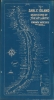
Sable Island Graveyard of the Atlantic Known Wrecks since 1800 A.D.
1948 (dated) 36.5 x 19.75 in (92.71 x 50.165 cm) 1 : 54000
1948 (dated) 36.5 x 19.75 in (92.71 x 50.165 cm) 1 : 54000
Description
FOR THE ORIGINAL ANTIQUE MAP, WITH HISTORICAL ANALYSIS, CLICK HERE.
Digital Map Information
Geographicus maintains an archive of high-resolution rare map scans. We scan our maps at 300 DPI or higher, with newer images being 600 DPI, (either TIFF or JPEG, depending on when the scan was done) which is most cases in suitable for enlargement and printing.
Delivery
Once you purchase our digital scan service, you will receive a download link via email - usually within seconds. Digital orders are delivered as ZIP files, an industry standard file compression protocol that any computer should be able to unpack. Some of our files are very large, and can take some time to download. Most files are saved into your computer's 'Downloads' folder. All delivery is electronic. No physical product is shipped.
Credit and Scope of Use
You can use your digial image any way you want! Our digital images are unrestricted by copyright and can be used, modified, and published freely. The textual description that accompanies the original antique map is not included in the sale of digital images and remains protected by copyright. That said, we put significant care and effort into scanning and editing these maps, and we’d appreciate a credit when possible. Should you wish to credit us, please use the following credit line:
Courtesy of Geographicus Rare Antique Maps (https://www.geographicus.com).
How Large Can I Print?
In general, at 300 DPI, you should at least be able to double the size of the actual image, more so with our 600 DPI images. So, if the original was 10 x 12 inches, you can print at 20 x 24 inches, without quality loss. If your display requirements can accommodate some loss in image quality, you can make it even larger. That being said, no quality of scan will allow you to blow up at 10 x 12 inch map to wall size without significant quality loss. For more information, it is best consult a printer or reprographics specialist.
Refunds
If the high resolution image you ordered is unavailable, we will fully refund your purchase. Otherwise, digital images scans are a service, not a tangible product, and cannot be returned or refunded once the download link is used.
Cartographer
Donald Stewart Johnson (fl. c. 1938 - 1948) was the Superintendent of Sable Island from 1939 -1948, except for a period during the Second World War when he helped to set up the Royal Canadian Navy's Fleet Air Arm. His father had been captain of a ship that brought supplies to the island, allowing him to become acquainted with it from a young age. After briefly attending university and working for the Humane Establishment on Sable Island, Johnson joined the Royal Canadian Mounted Police as a constable. Before returning to Sable Island as its superintendent, he worked several jobs with the Mounties and on ships in the Atlantic while also developing his artistic skills as an illustrator. Johnson was known as the 'Atlantic Cowboy' as he often rode horses to get around on Sable Island (the island is famous for a distinctive breed of horse, whose origin is unknown but most likely were resettled after being seized from Acadians during their expulsion by the British during the French and Indian War). More by this mapmaker...
References
OCLC 5568667, 855419142, 1084819647, 977207908.