Digital Image: 1837 Robert E. Lee Map of Saint Louis (St. Louis) Harbor, Missouri
SaintLouisHarbor-robertelee-1837_d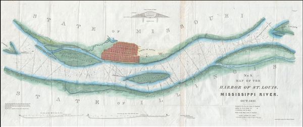

Title
No. 3. Map of the Harbor of St. Louis, Mississippi River. Oct. 1837.
1837 (dated) 18 x 42 in (45.72 x 106.68 cm) 1 : 12000
1837 (dated) 18 x 42 in (45.72 x 106.68 cm) 1 : 12000
Description
FOR THE ORIGINAL ANTIQUE MAP, WITH HISTORICAL ANALYSIS, CLICK HERE.
Digital Map Information
Geographicus maintains an archive of high-resolution rare map scans. We scan our maps at 300 DPI or higher, with newer images being 600 DPI, (either TIFF or JPEG, depending on when the scan was done) which is most cases in suitable for enlargement and printing.
Delivery
Once you purchase our digital scan service, you will receive a download link via email - usually within seconds. Digital orders are delivered as ZIP files, an industry standard file compression protocol that any computer should be able to unpack. Some of our files are very large, and can take some time to download. Most files are saved into your computer's 'Downloads' folder. All delivery is electronic. No physical product is shipped.
Credit and Scope of Use
You can use your digial image any way you want! Our digital images are unrestricted by copyright and can be used, modified, and published freely. The textual description that accompanies the original antique map is not included in the sale of digital images and remains protected by copyright. That said, we put significant care and effort into scanning and editing these maps, and we’d appreciate a credit when possible. Should you wish to credit us, please use the following credit line:
Courtesy of Geographicus Rare Antique Maps (https://www.geographicus.com).
How Large Can I Print?
In general, at 300 DPI, you should at least be able to double the size of the actual image, more so with our 600 DPI images. So, if the original was 10 x 12 inches, you can print at 20 x 24 inches, without quality loss. If your display requirements can accommodate some loss in image quality, you can make it even larger. That being said, no quality of scan will allow you to blow up at 10 x 12 inch map to wall size without significant quality loss. For more information, it is best consult a printer or reprographics specialist.
Refunds
If the high resolution image you ordered is unavailable, we will fully refund your purchase. Otherwise, digital images scans are a service, not a tangible product, and cannot be returned or refunded once the download link is used.
Cartographer
Robert E. Lee (Jan 19, 1807 - October 12, 1870) was an American career military officer most famous for commanding the Confederate Army of Northern Virginia during the American Civil War. Lee's brilliance as a military commander, despite his adamant opposition to both slavery and succession, nearly led to Confederate victory in the Civil War. His military achievements and significance are far too great for us to cover here. His role as a cartographer is on the other hand often overlooked. Lee was born to an aristocratic Virginia family that unfortunately fell on hard times in his youth. As a young man Lee attended Extern View School and later West Point Military Academy. His focus was engineering and after graduating he joined the Army Corps of Engineers. Initially Lee was stationed at Cockspur Island, Georgia, where he worked on plans to construct a fort to protect the Savannah River. Later he helped to survey the Ohio-Michigan Boundary. Promoted to First Lieutenant Lee was assigned to supervise engineering work on St. Louis Harbor and to map Des Moines and Rock Island Rapids, both major obstacles to commercial navigation on the Mississippi. Promoted to Captain for his successes he became resident engineer at Fort Hamilton. With the outbreak of the Mexican-American war Lee earned numerous distinctions, emerging form the war as one of America's boldest and most brilliant military commanders. In 1859 he put down John Brown's slave revolt at Harper's Ferry. With the election of Abraham Lincoln and the outbreak of the American Civil War, Lee took on his most significant role as commander of the Confederate Army of Northern Virginia. The rest is, as they say, history. More by this mapmaker...
Source
25th Congress, 2nd Session, Senate Doc. #139 (Washington) 1837).
References
Koepp, D., Exploration and mapping of the American West: selected essays, no. 316.