This item has been sold, but you can get on the Waitlist to be notified if another example becomes available, or purchase a digital scan.
1837 Robert E. Lee Map of Saint Louis (St. Louis) Harbor, Missouri
SaintLouisHarbor-robertelee-1837$250.00

Title
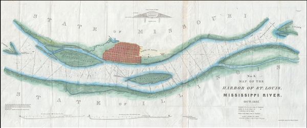
No. 3. Map of the Harbor of St. Louis, Mississippi River. Oct. 1837.
1837 (dated) 18 x 42 in (45.72 x 106.68 cm) 1 : 12000
1837 (dated) 18 x 42 in (45.72 x 106.68 cm) 1 : 12000
Description
A scarce 1837 map of the Mississippi River in the vicinity of St. Louis, Missouri by Robert E. Lee. Centered on the Mississippi River and oriented to the west, this map covers from Cahoe Island, past the sprawling city of Saint Louis, northwards as far as Cascarot Island. The detail through is stupendous with individual buildings, farms, and stores alongside the river being noted - often with family names.
The map presents a plan prepared by then 30 year old Robert E. Lee, an Army Corps of Engineers First Lieutenant, to build a dike to resolve the problem of Bloody Islands, seen here just north of St. Louis. Bloody Island began forming around 1800 causing the main channel of the Mississippi to flow on the Illinois side of the island, thus silting up Saint Louis harbor. Lee dyke, presented here in two sections, was intended to force the main channel of the Mississippi to west of the island. The action of the river would thus wash away the silt collecting in Saint Louis Harbor. The project was successful and 20 years later, the island was subsumed into the Illinois shoreline.
The survey work behind this map was completed by a party under the command of Robert E. Lee. It was drafted by M. C. Meigs, and Henry Kayser. The engraving and printing was accomplished by W. J. Stone of Washington, D.C. It was published a Senate report for the 25th Congress, 2nd Secession, 1837.
Cartographer
Robert E. Lee (Jan 19, 1807 - October 12, 1870) was an American career military officer most famous for commanding the Confederate Army of Northern Virginia during the American Civil War. Lee's brilliance as a military commander, despite his adamant opposition to both slavery and succession, nearly led to Confederate victory in the Civil War. His military achievements and significance are far too great for us to cover here. His role as a cartographer is on the other hand often overlooked. Lee was born to an aristocratic Virginia family that unfortunately fell on hard times in his youth. As a young man Lee attended Extern View School and later West Point Military Academy. His focus was engineering and after graduating he joined the Army Corps of Engineers. Initially Lee was stationed at Cockspur Island, Georgia, where he worked on plans to construct a fort to protect the Savannah River. Later he helped to survey the Ohio-Michigan Boundary. Promoted to First Lieutenant Lee was assigned to supervise engineering work on St. Louis Harbor and to map Des Moines and Rock Island Rapids, both major obstacles to commercial navigation on the Mississippi. Promoted to Captain for his successes he became resident engineer at Fort Hamilton. With the outbreak of the Mexican-American war Lee earned numerous distinctions, emerging form the war as one of America's boldest and most brilliant military commanders. In 1859 he put down John Brown's slave revolt at Harper's Ferry. With the election of Abraham Lincoln and the outbreak of the American Civil War, Lee took on his most significant role as commander of the Confederate Army of Northern Virginia. The rest is, as they say, history. More by this mapmaker...
Source
25th Congress, 2nd Session, Senate Doc. #139 (Washington) 1837).
Condition
Very good. Some creasing. Backed with archival tissue. Some wear and toning on original fold lines.
References
Koepp, D., Exploration and mapping of the American West: selected essays, no. 316.