1930 Trzaska, Evert, and Michalski Road Map of Poland
SamochodowaPolski-trzaska-1930$1,250.00


Title
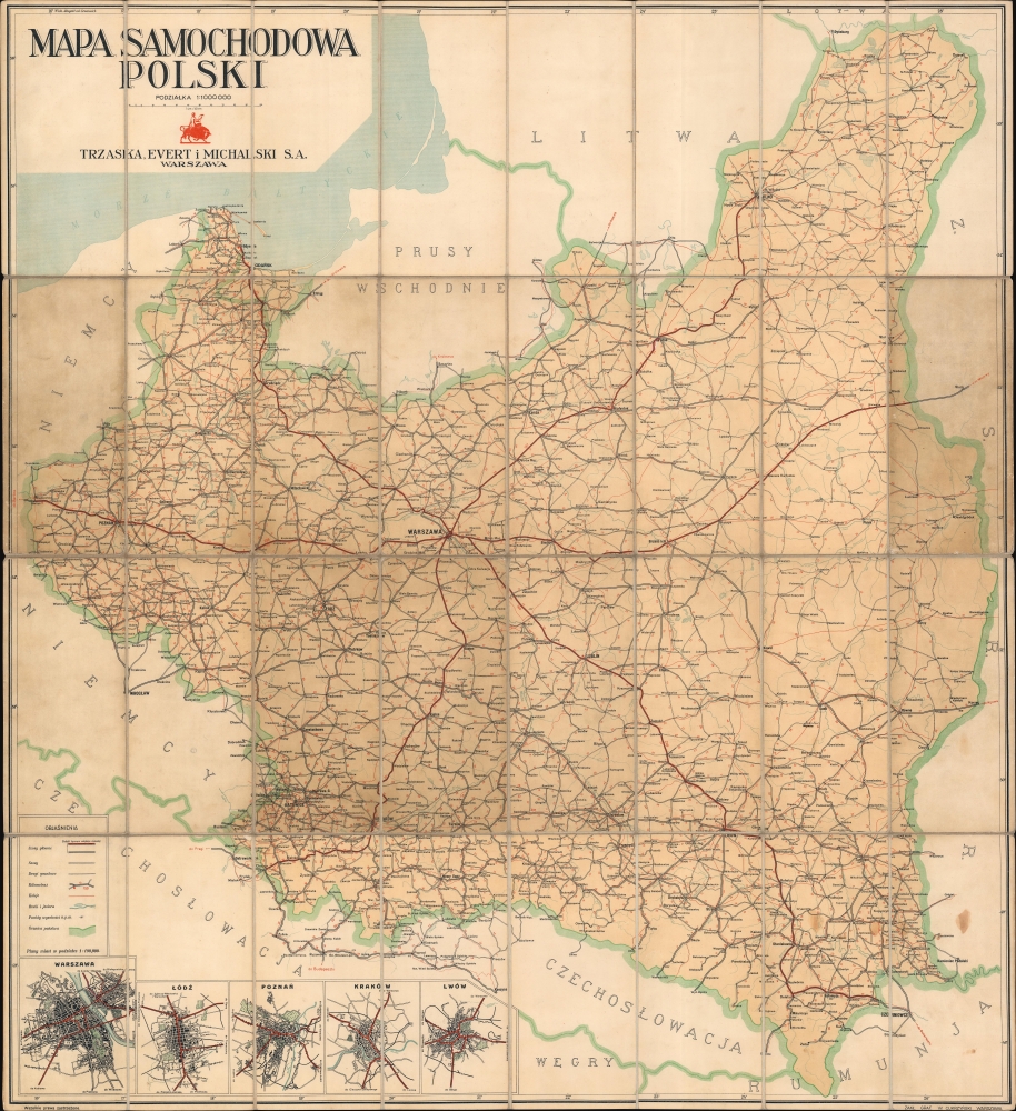
Mapa Samochodowa Polski.
1930 (undated) 37.5 x 34.25 in (95.25 x 86.995 cm) 1 : 1000000
1930 (undated) 37.5 x 34.25 in (95.25 x 86.995 cm) 1 : 1000000
Description
This is the Trzaska, Evert, and Michalski 1930 Interwar map of Poland under the Second Polish Republic. It is one of the few large scale maps of Poland from its brief period of unified independence between World War I (1914 - 1918), and the 1939 Nazi occupation.
A Closer Look
The map illustrates a reconstituted Poland. Cities, towns, and villages are labeled throughout, with 'main roads', 'roads', and 'dirt roads' identified. Important cities, such as Warsaw, Krakow, Wilno, Lwów (Lviv), and Gdansk, are highlighted with intercity milage noted. At Poland's borders, small notations mark the way to Prague, Budapest, Berlin, Bucharest, and Moscow.Second Polish Republic (1918 - 1939)
The Second Polish Republic, officially known as the Republic of Poland, was established in 1918 following the end of World War I, when Poland regained its sovereignty after 123 years of partitions by Austria-Hungary, Germany, and Russia. The newly independent Poland faced significant challenges, including territorial disputes and a devastated economy. The period between the two World Wars was nonetheless marked by economic, social, and territorial growth, including gains from the Soviet Union in the Polish-Soviet War (1919 - 1921). The Republic ceased to exist in 1939 when it was invaded by Nazi Germany and the Soviet Union, leading to its division under the Molotov-Ribbentrop Pact.Publication History and Census
This map was published by the Trzaska, Evert, and Michalski Publishing House in 1930. An example is part of the collection of the Institute of Geography and Spatial Organization of the Polish Academy of Sciences. Two more examples are cataloged in OCLC which are part of the collections at the Staatsbibliothek zu Berlin and the National Library of Poland.Cartographer
The Trzaska, Evert, and Michalski Publishing House (1919 - 1945, 1945 - 1951) was founded in Warsaw, Poland, by two booksellers, Władysław Trzaska (May 7, 1881 - December 21, 1964) and Jan Michalski, and Ludwik Józef Evert (September 23, 1863 - March 20, 1945), an industrialist and senator. The publishing house began as a bookstore founded by Michalski and Trzaska in 1916, with publishing operations beginning on May 20, 1920. By 1921 it was a joint stock company. By 1939, they operated offices in Częstochowa, Gdynia, Katowice, Kraków, Łódź, Lublin, Łuck, Lviv, Poznań and Vilnius. They became one of the most renowned bookstores of the interwar period, with their books winning the Grand Prix at the 1937 Paris Exposition Universelle. Their output included dictionaries, popular science publications, textbooks, and works of geography, literature, art, culture, and history. They also published several popular series, including 'The Knowledge Library', 'The Automobilist's Library', 'The Travel Library', and 'The Photographic Library'. World War II erupted and did severe damage to the business. Their warehouses were destroyed during the 1939 siege of Warsaw and their manuscripts and finished books were destroyed in the National Printing House in Krakow during the September Campaign. Publishing was suspended during World War II, but the bookshop remained open (under a German name) and moved to a different location. After the war, the shop moved again, and publishing resumed in 1945. State-owned businesses took over all publishing in 1951, ending that part of Trzaska, Evert, and Michalski's business. Trzaska ran the bookstore until 1963. More by this mapmaker...
Condition
Very good. Dissected and mounted on linen in 32 panels. Toning.
References
CBGiOŚ. IGiPZ PAN, call no. D.7451. OCLC 1036610944.