Digital Image: 1926 Edwards Pictorial Historical View of San Antonio, Texas
SanAntonioPictorial-edwards-1926_d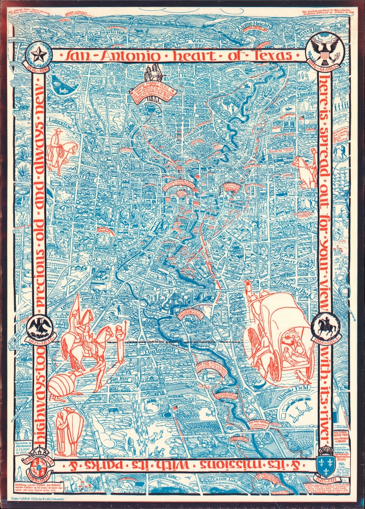

Title
Historic guide map to San Antonio de Bexar and environs.
1926 (dated) 38.25 x 27 in (97.155 x 68.58 cm) 1 : 18102
1926 (dated) 38.25 x 27 in (97.155 x 68.58 cm) 1 : 18102
Description
FOR THE ORIGINAL ANTIQUE MAP, WITH HISTORICAL ANALYSIS, CLICK HERE.
Digital Map Information
Geographicus maintains an archive of high-resolution rare map scans. We scan our maps at 300 DPI or higher, with newer images being 600 DPI, (either TIFF or JPEG, depending on when the scan was done) which is most cases in suitable for enlargement and printing.
Delivery
Once you purchase our digital scan service, you will receive a download link via email - usually within seconds. Digital orders are delivered as ZIP files, an industry standard file compression protocol that any computer should be able to unpack. Some of our files are very large, and can take some time to download. Most files are saved into your computer's 'Downloads' folder. All delivery is electronic. No physical product is shipped.
Credit and Scope of Use
You can use your digial image any way you want! Our digital images are unrestricted by copyright and can be used, modified, and published freely. The textual description that accompanies the original antique map is not included in the sale of digital images and remains protected by copyright. That said, we put significant care and effort into scanning and editing these maps, and we’d appreciate a credit when possible. Should you wish to credit us, please use the following credit line:
Courtesy of Geographicus Rare Antique Maps (https://www.geographicus.com).
How Large Can I Print?
In general, at 300 DPI, you should at least be able to double the size of the actual image, more so with our 600 DPI images. So, if the original was 10 x 12 inches, you can print at 20 x 24 inches, without quality loss. If your display requirements can accommodate some loss in image quality, you can make it even larger. That being said, no quality of scan will allow you to blow up at 10 x 12 inch map to wall size without significant quality loss. For more information, it is best consult a printer or reprographics specialist.
Refunds
If the high resolution image you ordered is unavailable, we will fully refund your purchase. Otherwise, digital images scans are a service, not a tangible product, and cannot be returned or refunded once the download link is used.
Cartographer
Emily Edwards (October 7, 1888 - February 16, 1980) was an artist, historian, and educator based in San Antonio, Texas. She was born and raised in San Antonio; her mother died when she was young and she and her sisters were sent to the Ursaline Academy, a boarding school, there, where her artistic talents were first recognized. Edwards continued her education at the San Antonio Female Institute and took classes with the Italian-born sculptor Pompeo Coppini (1870 - 1957), who had immigrated to the United States and settled in San Antonio. In 1905, Edwards moved to Chicago to attend the Art Institute of Chicago, where she studied with some of the leading artists in the city, including Enella Benedict (1858 - 1942), Ralph Elmer Clarkson (1861 - 1942), Harry Mills Walcott (1870 - 1944), and John Vanderpoel (1857 - 1911). Edwards volunteered to teach art classes at Jane Addams' Hull House and worked as a teacher at the Francis W. Parker School and several other schools in Chicago. In 1917, Edwards returned to San Antonio to teach at Brackenridge High School but by 1920 had left again, first to teach at a mountain mission in West Virginia, then to New York City to work as a stage designer, then to Provincetown, Massachusetts to work as a puppeteer, then briefly returning to Hull House in Chicago before coming back to San Antonio. It was at this point (1924) that she and Rena Maverick Green (1874 - 1962) cofounded the San Antonio Conservation Society, with Edwards serving as its first president. The organization was initially focused on preventing the cementing over of a part of the San Antonio River for flood control purposes. Working with other organizations, the city, architect Robert H.H. Hugman (1902 - 1980), and, eventually, the Works Progress Administration, the Conservation Society was instrumental in establishing the San Antonio River Walk, now widely regarded as the city's main tourist attraction. The Conservation Society also worked to rescue several historic buildings in downtown San Antonio from destruction in its early years. To raise funds for the society, Edwards staged puppet shows around town and drew a remarkable historical pictorial map of the city. Despite all these efforts, Edwards still managed to travel to Mexico in the summers of 1925 and 1926, where she met artist Diego Rivera (1886 - 1957), who became a teacher and lifelong friend. Edwards spent most of the next decade in Mexico, publishing books on Rivera's frescoes and Mexican frescoes more generally, producing a historical map of Mexico City similar to her earlier San Antonio map, and gaining a reputation as a talented artist herself, mostly with watercolors and prints. In 1927, while in Mexico, Edwards married Librado de Cantabrana and had a child named Basilio that died in infancy. By the late 1930s, Edwards had gotten divorced, left Mexico, and returned to Hull House in Chicago to work as the director of its art program. In the late 1950s, Edwards returned to San Antonio and focused on preserving the river walk, and wrote three more books, a book on frescoes that was the culmination of years of study, Painted Walls of Mexico. From Prehistoric Times until Today, a book on the history of her alma mater, the Ursuline Academy, and a biography of local architect, engineer, and politician François P. Giraud (1818 - 1877), the latter two published posthumously. More by this mapmaker...