1926 Edwards Pictorial Historical View of San Antonio, Texas
SanAntonioPictorial-edwards-1926$6,200.00

Title
Historic guide map to San Antonio de Bexar and environs.
1926 (dated) 38.25 x 27 in (97.155 x 68.58 cm) 1 : 18102
1926 (dated) 38.25 x 27 in (97.155 x 68.58 cm) 1 : 18102
Description
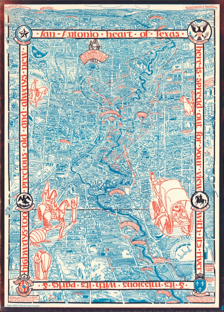
This is Emily Edwards' 1926 historical pictorial map of San Antonio, Texas. This map was issued to raise funds for the preservation of the San Antonio River and the establishment of San Antonio's River Walk - today an iconic part of the city. As an American pictorial map, Edwards' map is early, predating the earliest iconic work of Jo Mora by one year.
Other structures labelled in red include churches, villas, mission buildings, hotels, abodes, cemeteries, homes of the post-Independence era (often labelled with the names of the family owning them), and, of course, the Alamo. Large red ink illustrations refer to the city's history, including the one at top labelled 'Indian Market Place' initially referred to by the Spanish as San Pedro, after a nearby springs where the local Payaya people lived. More modern structures depicted in blue include neighborhoods, parks, schools, more churches and cemeteries, rail and streetcar lines, and sports fields. Some locations combine the historic with the modern, such as Fort Sam Houston and the 'Sunset R.R.' at right. The text in the interior border around the main part of the map reads: 'San Antonio, heart of Texas, here is spread out for your view with its river and its missions, with its parks and highways, too - precious, old and always new.' Along the banner are symbols of the various governments that have ruled over Texas, including the Spanish Crown, the Mexican Republic, the Republic of Texas, and the Confederate States of America.
Regarding the modern structures, the importance of San Antonio for the early history of aviation in the U.S., and particularly military aviation, is readily apparent. In addition to Fort Sam Houston, Kelly Field at far left towards bottom, Brooks Field at bottom-right, and Stinson Field at bottom-center all hosted airfields at the time of publication. Fort Sam Houston is notable as having hosted the first military flight in the U.S. when Lt. Benjamin Foulois flew in a Wright biplane on March 2, 1910. Kelly Field played a key role in training U.S. Army aviators during the World War II (1939 - 1945). Stinson Field, now Stinson Municipal Airport, was used for military purposes during both world wars, but turned over to the city after World War II and is now the second oldest continuously-operated general aviation (civilian) airfield in the U.S.
This map is both highly scarce and highly desirable, only appearing on the market twice in recent years. Among institutional collections, it is only held by Southern Methodist University, the Daughters of the Republic of Texas Library, the University of Georgia, and the David Rumsey Historical Map Collection.
A Closer Look
Oriented with north at top, coverage extends as far north as the North Loop, the basis for the northern portion of Interstate-410, which surrounds the city, to the south just beyond Chavaneaux Road, which is likewise the basis for the southern portion of the I-410 loop today. Buildings throughout the city are illustrated and labelled in blue, while red lettering indicates historic structures as well as homes older than 50 years (at the time of publication, 1876 or earlier). Red lines trace the acequias (irrigation ditches) built by Franciscan missionaries in the early 18th century, which gave the city its shape as well as its water. A related irrigation dam (the Espada Dam) on the San Antonio River is also noted; built by the Franciscans in 1740, it is the oldest dam in the U.S.Other structures labelled in red include churches, villas, mission buildings, hotels, abodes, cemeteries, homes of the post-Independence era (often labelled with the names of the family owning them), and, of course, the Alamo. Large red ink illustrations refer to the city's history, including the one at top labelled 'Indian Market Place' initially referred to by the Spanish as San Pedro, after a nearby springs where the local Payaya people lived. More modern structures depicted in blue include neighborhoods, parks, schools, more churches and cemeteries, rail and streetcar lines, and sports fields. Some locations combine the historic with the modern, such as Fort Sam Houston and the 'Sunset R.R.' at right. The text in the interior border around the main part of the map reads: 'San Antonio, heart of Texas, here is spread out for your view with its river and its missions, with its parks and highways, too - precious, old and always new.' Along the banner are symbols of the various governments that have ruled over Texas, including the Spanish Crown, the Mexican Republic, the Republic of Texas, and the Confederate States of America.
Regarding the modern structures, the importance of San Antonio for the early history of aviation in the U.S., and particularly military aviation, is readily apparent. In addition to Fort Sam Houston, Kelly Field at far left towards bottom, Brooks Field at bottom-right, and Stinson Field at bottom-center all hosted airfields at the time of publication. Fort Sam Houston is notable as having hosted the first military flight in the U.S. when Lt. Benjamin Foulois flew in a Wright biplane on March 2, 1910. Kelly Field played a key role in training U.S. Army aviators during the World War II (1939 - 1945). Stinson Field, now Stinson Municipal Airport, was used for military purposes during both world wars, but turned over to the city after World War II and is now the second oldest continuously-operated general aviation (civilian) airfield in the U.S.
Publication History and Census
This map was produced in 1926 by Emily Edwards, a co-founder of the San Antonio Conservation Society (see biography below), and published by the Society to raise funds for its efforts, namely to prevent the San Antonio River from being paved over in an effort to prevent floods. Thanks to the work of Edwards and her colleagues, the sewer-paving project was halted and eventually replaced by the San Antonio River Walk, a lovely riverside pedestrian walkway through the historic part of the city which has become one of its major attractions.This map is both highly scarce and highly desirable, only appearing on the market twice in recent years. Among institutional collections, it is only held by Southern Methodist University, the Daughters of the Republic of Texas Library, the University of Georgia, and the David Rumsey Historical Map Collection.
Cartographer
Emily Edwards (October 7, 1888 - February 16, 1980) was an artist, historian, and educator based in San Antonio, Texas. She was born and raised in San Antonio; her mother died when she was young and she and her sisters were sent to the Ursaline Academy, a boarding school, there, where her artistic talents were first recognized. Edwards continued her education at the San Antonio Female Institute and took classes with the Italian-born sculptor Pompeo Coppini (1870 - 1957), who had immigrated to the United States and settled in San Antonio. In 1905, Edwards moved to Chicago to attend the Art Institute of Chicago, where she studied with some of the leading artists in the city, including Enella Benedict (1858 - 1942), Ralph Elmer Clarkson (1861 - 1942), Harry Mills Walcott (1870 - 1944), and John Vanderpoel (1857 - 1911). Edwards volunteered to teach art classes at Jane Addams' Hull House and worked as a teacher at the Francis W. Parker School and several other schools in Chicago. In 1917, Edwards returned to San Antonio to teach at Brackenridge High School but by 1920 had left again, first to teach at a mountain mission in West Virginia, then to New York City to work as a stage designer, then to Provincetown, Massachusetts to work as a puppeteer, then briefly returning to Hull House in Chicago before coming back to San Antonio. It was at this point (1924) that she and Rena Maverick Green (1874 - 1962) cofounded the San Antonio Conservation Society, with Edwards serving as its first president. The organization was initially focused on preventing the cementing over of a part of the San Antonio River for flood control purposes. Working with other organizations, the city, architect Robert H.H. Hugman (1902 - 1980), and, eventually, the Works Progress Administration, the Conservation Society was instrumental in establishing the San Antonio River Walk, now widely regarded as the city's main tourist attraction. The Conservation Society also worked to rescue several historic buildings in downtown San Antonio from destruction in its early years. To raise funds for the society, Edwards staged puppet shows around town and drew a remarkable historical pictorial map of the city. Despite all these efforts, Edwards still managed to travel to Mexico in the summers of 1925 and 1926, where she met artist Diego Rivera (1886 - 1957), who became a teacher and lifelong friend. Edwards spent most of the next decade in Mexico, publishing books on Rivera's frescoes and Mexican frescoes more generally, producing a historical map of Mexico City similar to her earlier San Antonio map, and gaining a reputation as a talented artist herself, mostly with watercolors and prints. In 1927, while in Mexico, Edwards married Librado de Cantabrana and had a child named Basilio that died in infancy. By the late 1930s, Edwards had gotten divorced, left Mexico, and returned to Hull House in Chicago to work as the director of its art program. In the late 1950s, Edwards returned to San Antonio and focused on preserving the river walk, and wrote three more books, a book on frescoes that was the culmination of years of study, Painted Walls of Mexico. From Prehistoric Times until Today, a book on the history of her alma mater, the Ursuline Academy, and a biography of local architect, engineer, and politician François P. Giraud (1818 - 1877), the latter two published posthumously. More by this mapmaker...
Condition
Very good. Edge wear. Minor edge tears professionally repaired on verso.
References
Rumsey 14078.000. OCLC 310562860. Cosentino, D., 'Picturing American Cities in the Twentieth Century: Emily Edwards's Maps of San Antonio and Mexico City' Imago Mundi: The International Journal for the History of Cartography, Vol. 65, No. 2. (2013).