1874 Langley / Britton and Rey Map of San Francisco
SanFrancisco-brittonrey-1874$850.00

Title
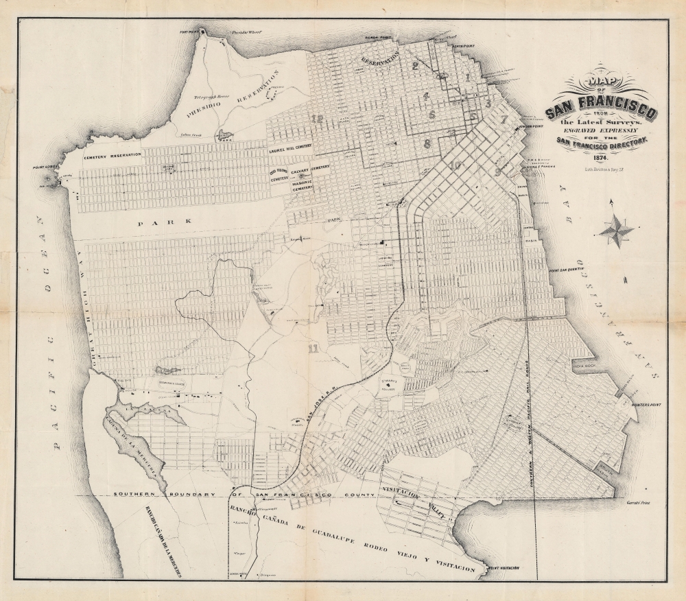
Map of San Francisco from the latest surveys. Engraved expressly for the San Francisco Directory. 1874.
1874 (dated) 17 x 20 in (43.18 x 50.8 cm) 1 : 31680
1874 (dated) 17 x 20 in (43.18 x 50.8 cm) 1 : 31680
Description
An important map of San Francisco produced by Britton and Rey for the 1874 edition of The San Francisco Directory. Notably, it reflects efforts to plan and develop the western and southern portion of the city to accommodate its rapidly growing population.
'Reservations' here refer to land set aside for government or military use. The Black Point Reservation in the northeastern part of the city became the site of Fort Mason, completed in 1912. The 'Cemetery Reservation' in the north-western part of the city was also known as the Golden Gate Cemetery, City Cemetery, or Potter's Field. At the turn of the 20th century, the city moved to end new burials within city boundaries, and then to relocate existing cemeteries. Thus, all the cemeteries seen here were converted over to other uses, with most graves being relocated to Colma, just south of San Francisco. At the start of the 20th century, the City Cemetery became a golf course and park, soon renamed Lincoln Park.
The presentation of Noe Valley, Bayview, Hunter's Point, and other neighborhoods in the southern portion of the city, as well as, to a lesser extent, the Mission District and Potrero Hill, is also based on presumed future development. Potrero Hill had been sparsely inhabited just a few years prior, but quickly became settled and industrialized following the resolution of disputes by the U.S. Supreme Court over the land between the descendants of Don Francisco de Haro, a Mexican ranchero, and post-Gold Rush squatters, along with the construction of the 'Long Bridge,' a horse-drawn railway built atop driven piles. At bottom-right, east of Visitacion Valley, lines of the Southern and Western Pacific Railroads extend over the Brisbane Lagoon via a long rail bridge. In subsequent decades, the Southern Pacific filled in this lagoon to create the Bayshore Yard; later, this land was utilized in the construction of the U.S.-101 highway.
In the oldest and most congested part of the city, 'Montgomery Ave.' (constructed in the early 1870s and renamed Columbus Ave. in 1909), also ghosted in, is conspicuous for cutting diagonally across the city's grid. Designed to link languishing North Beach with the main part of the city, the road's path required the destruction of numerous existing structures and levelling hills to create the smooth grade desired by city planners.
A Closer Look
The entire city and county of San Francisco is covered, along with the northern part of San Mateo County (now Daly City and Brisbane). Roads, railroads, and horsecar lines are indicated (curiously, the Clay Street Hill Railway, the city's first cable car, which opened the previous year, is not included). Parks, plazas, cemeteries, ferry landings, churches, city wards, and other important sites and features are labelled throughout the city. Notable among them are the 'Mission Church' (Mission Delores), the nearby Jewish Cemetery (a short-lived burial site in what is now Mission Delores Park), and the 'Saucelito Ferry,' with the city's old spelling. Naming conventions of sites within San Francisco also subsequently changed, not necessarily in a consistent way; for instance, 'Lake Honda' is now known as Laguna Honda, while 'Laguna de la Mercedes' became Anglicized as Lake Merced.'Reservations' here refer to land set aside for government or military use. The Black Point Reservation in the northeastern part of the city became the site of Fort Mason, completed in 1912. The 'Cemetery Reservation' in the north-western part of the city was also known as the Golden Gate Cemetery, City Cemetery, or Potter's Field. At the turn of the 20th century, the city moved to end new burials within city boundaries, and then to relocate existing cemeteries. Thus, all the cemeteries seen here were converted over to other uses, with most graves being relocated to Colma, just south of San Francisco. At the start of the 20th century, the City Cemetery became a golf course and park, soon renamed Lincoln Park.
Future Ambitions
This map is significant for positing the future development of the Richmond and Sunset Districts, while also ghosting in features such as creeks, lakes, and the Spring Valley Flume (which brought water to the city) that existed at the time. These areas, along with the intervening Golden Gate Park (here simply as 'park'), were merely conceptual rather than actual. Aside from the Cliff House, some scattered roadhouses, and the occasional asylum, infirmary, or racetrack, the entire western half of the city consisted of untamed wilderness and foreboding sand dunes. All that being said, the ultimate layout of the city largely corresponded to the grid seen here, based on plans laid out in the Board of Supervisors' Clement Ordinance of 1866 and the Outside Lands Ordinance of 1868 (the 'Outside Lands,' that is the future Richmond and Sunset Districts along with Golden Gate Park, had been granted to the city in 1866 by the U.S. Congress after a lengthy dispute with the federal government). The Richmond and Sunset maintained this geometric street grid and street names still mostly follow this north-south alphabetical order (from Anza St. to Yorba St.).The presentation of Noe Valley, Bayview, Hunter's Point, and other neighborhoods in the southern portion of the city, as well as, to a lesser extent, the Mission District and Potrero Hill, is also based on presumed future development. Potrero Hill had been sparsely inhabited just a few years prior, but quickly became settled and industrialized following the resolution of disputes by the U.S. Supreme Court over the land between the descendants of Don Francisco de Haro, a Mexican ranchero, and post-Gold Rush squatters, along with the construction of the 'Long Bridge,' a horse-drawn railway built atop driven piles. At bottom-right, east of Visitacion Valley, lines of the Southern and Western Pacific Railroads extend over the Brisbane Lagoon via a long rail bridge. In subsequent decades, the Southern Pacific filled in this lagoon to create the Bayshore Yard; later, this land was utilized in the construction of the U.S.-101 highway.
In the oldest and most congested part of the city, 'Montgomery Ave.' (constructed in the early 1870s and renamed Columbus Ave. in 1909), also ghosted in, is conspicuous for cutting diagonally across the city's grid. Designed to link languishing North Beach with the main part of the city, the road's path required the destruction of numerous existing structures and levelling hills to create the smooth grade desired by city planners.
Publication History and Census
This map was lithographed by San Francisco stalwarts Britton and Rey for inclusion in the 1874 edition of the The San Francisco Directory, published by Henry G. Langley. Langley issued his directory with regularity from the mid-19th to the early 20th century and adopted at least three map formats: the earliest providing an accurate representation of the city as it existed (as in Rumsey 3867.000, the edition drawn by Wackenreuder), the present layout by Britton and Rey begun in 1870, noteworthy for including the assumed future development mentioned above, and a chromolithographed map by George Wilbur (previously sold by us) that appeared in the 1890s. Though a precise census is difficult given the intermingling of digital and physical examples, the 1874 edition of the map looks to be held by the California Genealogical Society and Library, the California Historical Society, the University of California Berkeley, the California State Library, and Dartmouth University.Cartographer
Britton and Rey (1852 - 1906) was a lithographic firm based in San Francisco founded by Joseph Britton (1825 - 1901) and Jacques Joseph Rey (1820 - 1892). The leading firm in the area during the second half of the 19th century, Britton and Rey eventually earned the reputation of being the western Currier and Ives. They published both large-format and postcard views of California, as well as with stock certificates, stationery, and maps. Within the partnership, Rey was the artist and Britton the principal lithographer. Britton was also principally concerned with the business aspects of the firm. The firm also printed lithographs by other artists, including Thomas Almond Ayres (1816 - 1858), George Holbrook Baker (1824 - 1906), Charles Christian Nahl (1818 - 1878), and Frederick August Wenderoth (1819 - 1884). After Rey's death in 1892 and Britton's subsequent retirement, the firm passed to Rey's son, Valentine J. A. Rey, who ran the firm until at least the 1906 San Francisco earthquake and fire. A. Carlisle and Company, another San Francisco printer, acquired the remains of the Britton and Rey firm in 1916. For more information about Joseph Britton and Jacques Joseph Rey, please reference their individual biographies included in our cartographer database. More by this mapmaker...
Condition
Good. Toning and wear along fold lines, with minor areas of loss at fold intersections.
References
OCLC 27788939.