This item has been sold, but you can get on the Waitlist to be notified if another example becomes available, or purchase a digital scan.
1853 U.S.C.S. Map of San Francisco, California & Vicinity
SanFrancisco3-uscs-1853$200.00

Title
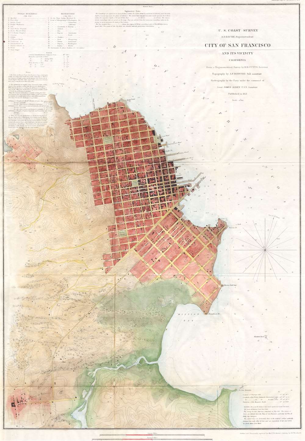
City of San Francisco and its Vicinity California.
1853 18 x 26 in (45.72 x 66.04 cm)
1853 18 x 26 in (45.72 x 66.04 cm)
Description
A rare coastal chart of San Francisco by the U. S. Coast Survey, 1853. Depicts the immediate city of San Francisco and surrounding areas as far as the Mission de Dolores or the Mission de San Francisco. Issued shortly following the gold rush, this early map depicts the city extending only about 8 city blocks from the waterfront. Labels piers, wharfs, parks and roads as well as indicating important individual buildings such as the City Hall, the Post Office, hospitals, and churches. The ocean areas have detailed depth soundings. Text on public buildings, reservoirs, sailing notes, shoals, and tidal notations are included on the top left and lower right hand corners of the map. This map is the second state of the 1853 edition. The first edition, in 1862 lacked depth soundings. Varies from the first 1853 state in the additional of tidal information in the upper left and corrections in the naming of the wharves and piers. Rumsey suggests that the actual city plan was taken from an earlier map produced Cook and Le Count. The interior topography comes from the Eddy map. Varies from the first state in the additional of tidal information in the upper right and corrections in the naming of the wharves and piers. The original trigonometrical survey for this map was prepared by R. D. Cutts. The topography was accomplished by A. F. Rodgers and the hydrography by James Alden. All work was produced under the supervision of A. D. Bache, one of the most influential superintendents in the history of the U.S. Coast Survey.
Cartographer
The Office of the Coast Survey (1807 - present) founded in 1807 by President Thomas Jefferson and Secretary of Commerce Albert Gallatin, is the oldest scientific organization in the U.S. Federal Government. Jefferson created the "Survey of the Coast," as it was then called, in response to a need for accurate navigational charts of the new nation's coasts and harbors. The spirit of the Coast Survey was defined by its first two superintendents. The first superintendent of the Coast Survey was Swiss immigrant and West Point mathematics professor Ferdinand Hassler. Under the direction of Hassler, from 1816 to 1843, the ideological and scientific foundations for the Coast Survey were established. These included using the most advanced techniques and most sophisticated equipment as well as an unstinting attention to detail. Hassler devised a labor intensive triangulation system whereby the entire coast was divided into a series of enormous triangles. These were in turn subdivided into smaller triangulation units that were then individually surveyed. Employing this exacting technique on such a massive scale had never before been attempted. Consequently, Hassler and the Coast Survey under him developed a reputation for uncompromising dedication to the principles of accuracy and excellence. Unfortunately, despite being a masterful surveyor, Hassler was abrasive and politically unpopular, twice losing congressional funding for the Coast Survey. Nonetheless, Hassler led the Coast Survey until his death in 1843, at which time Alexander Dallas Bache, a great-grandson of Benjamin Franklin, took the helm. Bache was fully dedicated to the principles established by Hassler, but proved more politically astute and successfully lobbied Congress to liberally fund the endeavor. Under the leadership of A. D. Bache, the Coast Survey completed its most important work. Moreover, during his long tenure with the Coast Survey, from 1843 to 1865, Bache was a steadfast advocate of American science and navigation and in fact founded the American Academy of Sciences. Bache was succeeded by Benjamin Pierce who ran the Survey from 1867 to 1874. Pierce was in turn succeeded by Carlile Pollock Patterson who was Superintendent from 1874 to 1881. In 1878, under Patterson's superintendence, the U.S. Coast Survey was reorganized as the U.S. Coast and Geodetic Survey (C & GS) to accommodate topographic as well as nautical surveys. Today the Coast Survey is part of the National Oceanic and Atmospheric Administration or NOAA as the National Geodetic Survey. More by this mapmaker...
Condition
Very Good condition. Professionally cleaned, flattened, and backed with archival paper. Blank on verso. Minor buckling of paper. Contemporary color. Wide margins.
References
Vogdes, Anthony W. A bibliography relating to the geology, paleontology and mineral resources of California, Sacramento: A.J. Johnson, 1896, p 253; Rumsey 3463.000; Phillips, Philip Lee. A List of Maps of America in the Library of Congress, p. 780.