Digital Image: 1905 Witaker and Ray Wall Pictorial Wall Map of the San Francisco Bay Area
SanFranciscoBayCounties-whitakerray-1905_d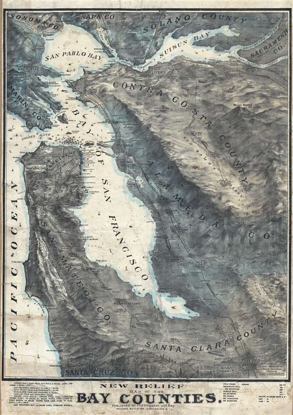

Title
New Relief Map of the Bay Counties.
1904 (undated) 42 x 31 in (106.68 x 78.74 cm) 1 : 100000
1904 (undated) 42 x 31 in (106.68 x 78.74 cm) 1 : 100000
Description
FOR THE ORIGINAL ANTIQUE MAP, WITH HISTORICAL ANALYSIS, CLICK HERE.
Digital Map Information
Geographicus maintains an archive of high-resolution rare map scans. We scan our maps at 300 DPI or higher, with newer images being 600 DPI, (either TIFF or JPEG, depending on when the scan was done) which is most cases in suitable for enlargement and printing.
Delivery
Once you purchase our digital scan service, you will receive a download link via email - usually within seconds. Digital orders are delivered as ZIP files, an industry standard file compression protocol that any computer should be able to unpack. Some of our files are very large, and can take some time to download. Most files are saved into your computer's 'Downloads' folder. All delivery is electronic. No physical product is shipped.
Credit and Scope of Use
You can use your digial image any way you want! Our digital images are unrestricted by copyright and can be used, modified, and published freely. The textual description that accompanies the original antique map is not included in the sale of digital images and remains protected by copyright. That said, we put significant care and effort into scanning and editing these maps, and we’d appreciate a credit when possible. Should you wish to credit us, please use the following credit line:
Courtesy of Geographicus Rare Antique Maps (https://www.geographicus.com).
How Large Can I Print?
In general, at 300 DPI, you should at least be able to double the size of the actual image, more so with our 600 DPI images. So, if the original was 10 x 12 inches, you can print at 20 x 24 inches, without quality loss. If your display requirements can accommodate some loss in image quality, you can make it even larger. That being said, no quality of scan will allow you to blow up at 10 x 12 inch map to wall size without significant quality loss. For more information, it is best consult a printer or reprographics specialist.
Refunds
If the high resolution image you ordered is unavailable, we will fully refund your purchase. Otherwise, digital images scans are a service, not a tangible product, and cannot be returned or refunded once the download link is used.
Cartographer
Whitaker and Ray (1895 – c. 1915) was an educational supply house and publication company active in San Francisco in the late 18th and early 20th century. The firm was originally founded in 1869 as an agricultural brokerage in Galt, California, by pioneer merchants Andrew Whitaker and Don Ray (1849 - April 12, 1910). Whitaker and Ray was immensely successful when Whitaker died in April of 1894, leaving his estate to his son, James Whitaker (1874 - 19??). Now headed by Don Ray and his son John Ray, the firm relocated to San Francisco and changed focus to publishing and educational supply. The firm incorporated in 1895 when it acquired the educational supply arm of the Bancroft Company, including the services of educator C. C. Adams and businessman Charles M. Wiggin. Wiggin previously headed the educational department at the Bancroft Company and moved, along with the sale, to manage Whitaker and Ray. They began publishing educational materials under their own imprint as early as 1896, but the bulk of their publications were issued between 1899 to 1906. The 1906 San Francisco Earthquake and Fire adversely affected their interests, ruining their original premises at 723 Market Street. Nonetheless, by 1909 they had established themselves at a larger more central location at 779-760 Mission Street. Around 1910, following Don Ray's death, their imprint changes to Whitaker and Ray-Wiggin Company, reflecting Charles Wiggin's ascent to partner. They continued to publish until at least 1915. More by this mapmaker...
References
OCLC 871336194.