1945 Dolph City Plan or Map of Savannah, Georgia
Savannah-dolph-1945$350.00


Title
Dolph's Map of Savannah, Georgia.
1945 (undated) 21.25 x 31.25 in (53.975 x 79.375 cm) 1 : 8700
1945 (undated) 21.25 x 31.25 in (53.975 x 79.375 cm) 1 : 8700
Description
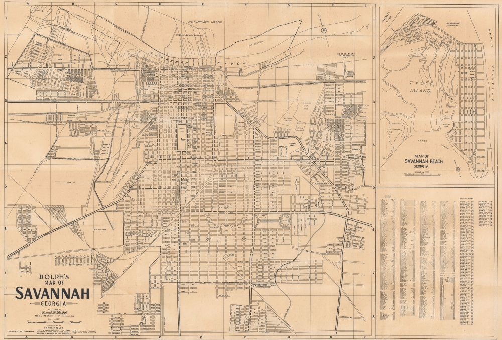
This is a c. 1945 Frank B. Dolph city map of Savannah, Georgia, depicting the city near the end of World War II.
A Closer Look
The map captures aspects of life in Savannah, identifying hotels, schools, hospitals, squares, and parks. The Pape School for Girls is labeled near Forsyth Park. Other identified locations include the Y.M.C.A., the Savannah Public Library, and the Cotton Exchange. Illustrated railroads include the Atlantic Coast Line Railroad, the Seaboard Air Line, and the Central of Georgia Railway. Diagonal black lines differentiate three federal housing projects (Fellwood Homes and Yamacraw Village) from the rest of the city. Outside the city limits, in grid box H7, a 'negro church and cemetery' is noted along Skidaway Road. Unfortunately, we have been unable uncover any concrete details about this church or cemetery. A smaller map focusing on Savannah Beach, Georgia, including Tybee Island, occupies the upper right corner.Southeastern Shipbuilding and Josiah Tattnall Homes
In the upper right, the Southeastern Shipbuilding Corporation is identified. The SSSC was founded in 1942 when it was awarded a contract by the Maritime Commission to build Liberty ships. It employed 46,000 people. By the end of the war, when the shipyard was closed, 88 Liberty ships and 18 Type C1 ships had been built. Josiah Tattnall Homes (just below the shipyard on this map and shaded with black diagonal lines), was built as a defense housing initiative along with Moses Rogers Grove, which appears in between the shipyard and Josiah Tattnall Homes. Josiah Tattnall consisted of 750 single-story units of three to six rooms, while 150 two-story multi-family blocks containing six units apiece were built at Moses Rogers Grove. These units opened in January 1943. Both these housing developments were meant to be impermanent but outlasted the war and became low-rent apartment complexes. Josiah Tattnall Homes survived until it was demolished between 2010 and 2013.Publication History and Census
This map was created and published by Frank B. Dolph c. 1945. OCLC locates three examples: Syracuse University, the University of Georgia, and the Georgia Historical Society.Cartographer
Frank B. Dolph (October 3, 1897 - November 26, 1975) was an American businessman and map publisher. Born in Great Neck, Long Island, New York, Dolph served as a Navy storekeeper during World War I. He began selling maps in 1919 after returning from England, likely for the George F. Cram Company, where he ultimately became an administrative aide. He also worked for the Rand McNally Company for some time before he founded his own map publishing firm, Dolph and Stewart, with his friend, sometime in the 1920s. Dolph and Stewart made maps throughout the 1920s and 1930s until they sold the firm in 1945 when Dolph decided to return to Florida. Dolph opened a new map publishing business, the Frank B. Dolph Map Co. in Ft. Lauderdale and published city plans of cities throughout the United States. Many of his maps were distributed by Chambers of Commerce or sold at newsstands. Real estate developers greatly appreciated his maps, those published by both the Dolph and Stewart Company and the Frank B. Dolph Company. Dolph retired as president of his firm around 1965, when he handed the business off to his son, Frank B. Dolph, Jr. Dolph worked with cartographer Theodore M. Politano for decades while operating the Frank B. Dolph Map Company. More by this mapmaker...
Condition
Good. Verso repairs to fold separations. Slight loss at some fold intersections. Foxing.
References
OCLC 712204341.