This item has been sold, but you can get on the Waitlist to be notified if another example becomes available, or purchase a digital scan.
1837 Blunt Maritime Map or Nautical Chart of the Savannah River
SavannahRiver-blunt-1837$112.50

Title
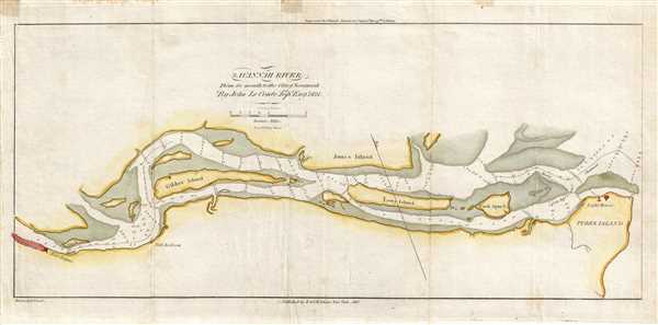
Savannah River From its Mouth to the City of Savannah.
1837 (dated) 7.5 x 16 in (19.05 x 40.64 cm) 1 : 60000
1837 (dated) 7.5 x 16 in (19.05 x 40.64 cm) 1 : 60000
Description
This is an 1837 Edmund Blunt map or chart of the Savannah River. The map depicts the Savannah River from Savannah to its mouth near Tybee Island. Predating the U.S. Coast Survey, the detail present here is astonishing. Several islands in the river are labeled, including Gibbet Island, Jones Island, Long Island, and Cock Spur Island. The main channel is illustrated by using a dashed line in two different sections of the river and Cock Spur Island Channel is labeled as well. Depth soundings are provided throughout. Along with Savannah, which is situated at the left border, Forth Hayne, Fort Jackson, and a light house on Tybee Island are depicted.
This map was drawn by Edmund Blunt from surveys conducted by John Le Conte, a topographical engineer, in 1821. Blunt published it in the 13th edition of his American Coast Pilot.
This map was drawn by Edmund Blunt from surveys conducted by John Le Conte, a topographical engineer, in 1821. Blunt published it in the 13th edition of his American Coast Pilot.
Cartographer
Edmund March Blunt (June 20, 1770 - 1862) was an American navigator, bookseller, chartmaker, and cartographer based in Newburyport, Massachusetts. Blunt was born in Portsmouth, New Hampshire in 1770. In 1796, along with the nominal assistance of prominent navigator Captain Lawrence Furlong, Blunt published The American Coast Pilot, one of the most important published works on American navigation. Although much of the work was plagiarized from British publications, the Coast Pilot was an immediate popular success. In response to the popularity of his work, Blunt published 21 subsequent editions, each with important updates and revisions. The first edition to contain map plates was printed in 1804. Following a fire that destroyed his offices at The Sign of the Bible in 1811, Blunt moved his business to New York and opened a new shop, The Sign of the Quadrant. His sons Edmund Jr. (1799 - 1866) and George William (1802 - 1878), joined the firm in 1824 and eventually took over the family business, renaming the firm 'E. and G. W. Blunt'. They both produced their own nautical books, charts, and instruments, as well as republished their father’s work. In 1830, Edmund accepted a position under Ferdinand Hassler at the United States Office of the Coast Survey. Much of Blunt's original work eventually found its way into U.S. Coast Survey Publications. George closed the firm in 1872 and sold the plates and chart copyrights to the U.S. Coast Survey and the U.S. Navy Hydrographic Office. Due to the quality and detail of Blunt's work, revised editions of his most important charts were republished well into the 1880s. More by this mapmaker...
Source
Blunt, E., American Coast Pilot (13th edition), 1837.
Condition
Very good. Wear along original fold lines. Old verso repairs along top margin. Light water stain along top margin not effecting printed area. Blank on verso.
References
OCLC 6223658.