1862 Colton Map of Virginia, Maryland, and the Chesapeake Bay
SeatWarVirginia-colton-1862$1,200.00
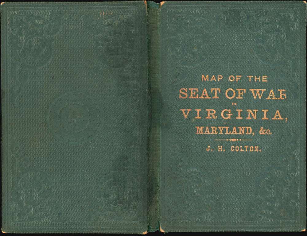

Title
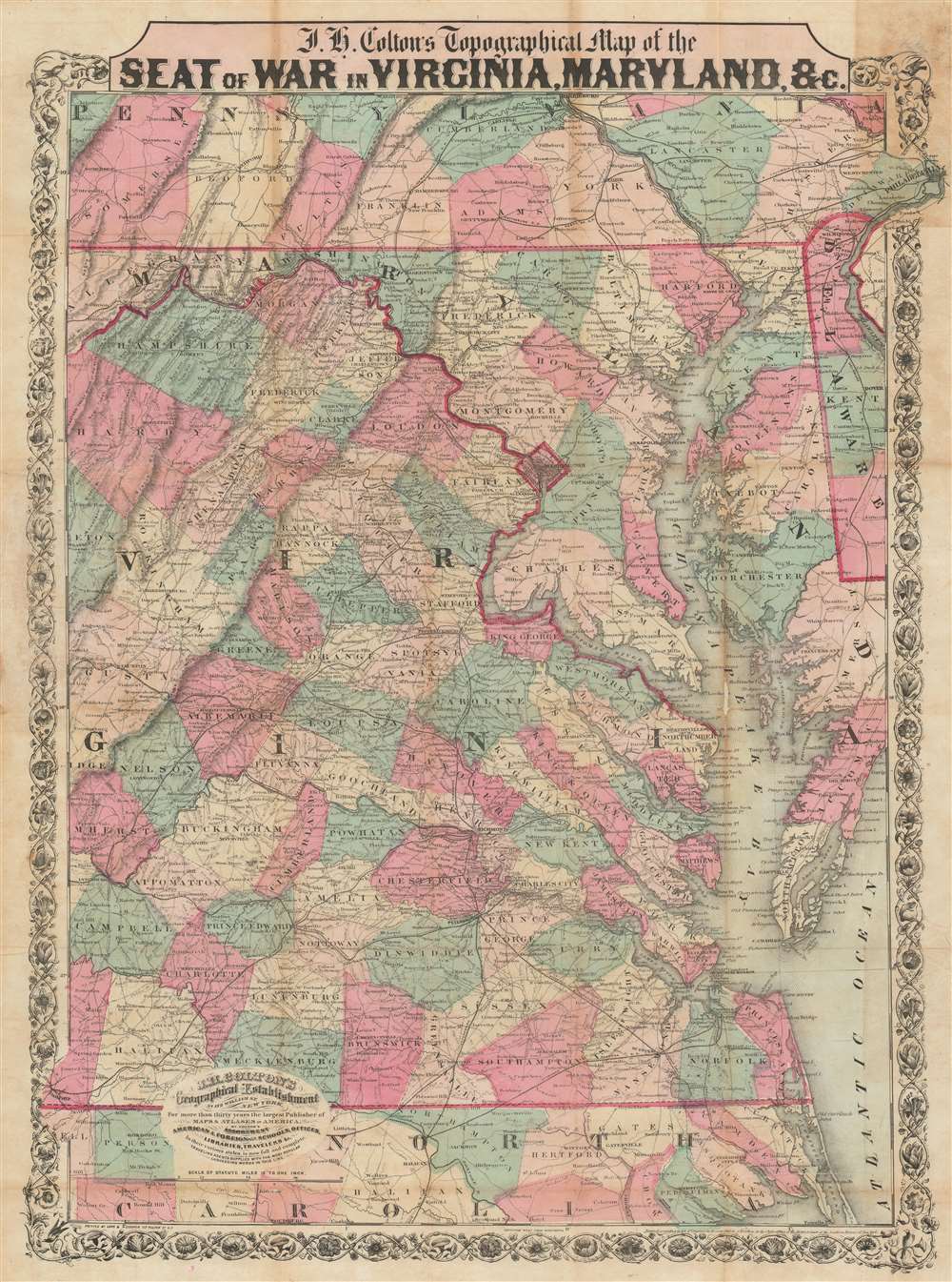
J.H. Colton's Topographical Map of the Seat of War in Virginia, Maryland, etc.
1862 (dated) 26.5 x 19.5 in (67.31 x 49.53 cm) 1 : 760000
1862 (dated) 26.5 x 19.5 in (67.31 x 49.53 cm) 1 : 760000
Description
This is a rare 1862 J. H. Colton map of Virginia, Maryland, and the Chesapeake Bay during the American Civil War (1861 - 1865). This map was issued for readers to follow Civil War events as they unfolded. In 1862, most of the Civil War had yet to come, but there was no doubt that most of the decisive battles would take place in the Mid-Atlantic theater, where the warring capitals stood just over 100 miles apart.
Following the War
The map depicts the Eastern Theater of War in the Mid-Atlantic Region, from Gettysburg, Pennsylvania (the 'high water mark of the Confederacy') south to North Carolina. The Union Army of the Potomac and General Robert E. Lee's Army of Northern Virginia fought over this territory from 1861 until 1865, when Lee surrendered to General Ulysses S. Grant at Appomattox Court House. Among the sites where future battles would unfold are: Appomattox Court House, marked with a simple 'C.H.' in Appomattox County, Virginia; Bull Run Creek and Manassas Junction, the site of the First and Second Battle of Bull Run, just southwest of Washington, D.C.; Antietam River and Sharpsburg, Maryland, the site of the Battle of Antietam, the bloodiest day in U.S. history, are located in western Maryland; and of course, Gettysburg, Pennsylvania. Numerous other battle locations, including Fredericksburg, Chancellorsville, Spotsylvania Court House, and Cold Harbor are also embraced.Publication History and Census
This map was created and published by J. H. Colton in 1862, the second year of the five-year war. It was printed in New York by Lang and Cooper - unusual as Colton typically printed his own material. Colton published this map as a reference for tracking the war's progress. It is not cataloged in OCLC, but examples are part of the institutional collections at the Library of Congress and the Leventhal Map Collection at the Boston Public Library. An example is also part of the David Rumsey Map Collection.CartographerS
Joseph Hutchins Colton (July 5, 1800 - July 29, 1893), often publishing as J. H. Colton, was an important American map and atlas publisher active from 1833 to 1897. Colton's firm arose from humble beginnings when he moved to New York in 1831 and befriended the established engraver, Samuel Stiles. He worked under Stiles as the 'Co.' in Stiles and Co. from 1833 to 1836. Colton quickly recognized an emerging market in railroad maps and immigrant guides. Not a cartographer or engraver himself, Colton's initial business practice mostly involved purchasing the copyrights of other cartographers, most notably David H. Burr, and reissuing them with updated engraving and border work. His first maps, produced in 1833, were based on earlier Burr maps and depicted New York State and New York City. Between 1833 and 1855, Colton proceeded to publish a large corpus of guidebooks and railroad maps, which proved popular. In the early 1850s, Colton brought his two sons, George Woolworth Colton (1827 - 1901) and Charles B. Colton (1832 - 1916), into the map business. G. W. Colton, trained as a cartographer and engraver, was particularly inspired by the idea of creating a large and detailed world atlas to compete with established European firms for the U.S. market. In 1855, G.W. Colton issued volume one of the impressive two-volume Colton's Atlas of the World. Volume two followed a year later. Possibly because of the expense of purchasing a two-volume atlas set, the sales of the Atlas of the World did not meet Colton's expectations, and so, in 1856, the firm also issued the atlas as a single volume. The maps contained in this superb work were all original engravings, and most bear an 1855 copyright. All of the maps were surrounded by an attractive spiral motif border that would become a hallmark of Colton's atlas maps well into the 1880s. In 1857, the slightly smaller Colton's General Atlas replaced the Atlas of the World. Most early editions of the General Atlas published from 1857 to 1859 do not have the trademark Colton spiral border, which was removed to allow the maps to fit into a smaller format volume. Their customers must have missed the border because it was reinstated in 1860 and remained in all subsequent publications of the atlas. There were also darker times ahead; in 1858, Colton was commissioned at a sum of 25,000 USD by the government of Bolivia to produce and deliver 10,000 copies of a large format map of that country. Although Colton completed the contract in good faith, delivering the maps at his own expense, he was never paid by Bolivia, which was at the time in the midst of a series of national revolutions. Colton would spend the remainder of his days fighting with the Bolivian and Peruvian governments over this payment, and in the end, after a congressional intervention, he received as much as 100,000 USD in compensation. Nonetheless, at the time, it was a disastrous blow. J. H. Colton and Company is listed as one of New York's failed companies in the postal record of 1859. This led Colton into the arms of Alvin Jewett Johnson and Ross C. Browning. The 1859 edition of Colton's General Atlas lists Johnson and Browning as the 'Successor's to J. H. Colton' suggesting an outright buyout, but given that both companies continued to publish separately, the reality is likely more complex. Whatever the case may have been, this arrangement gave Johnson and Browning access to many of Colton's map plates and gave birth to Johnson's New Illustrated (Steel Plate) Family Atlas. The Johnson's Atlas was published parallel to Colton's atlases well into the 1880s. The Colton firm itself subsequently published several other atlases including an Atlas of America, the Illustrated Cabinet Atlas, the Octavo Atlas of the Union, and Colton's Quarto Atlas of the World. They also published a large corpus of wall maps, pocket maps, and guides. The last known publications of the Colton firm date to 1897 and include a map and a view, both issued in association with the Merchant's Association of New York. Alice M. Colton married August R. Ohman (May 3, 1859 - April 22, 1934) on January 5, 1897. In 1898, Ohman joined the Colton firm, which continued to publish as Colton, Ohman & Co. until 1901. More by this mapmaker...
Lang and Cooper (fl. August 16, 1862 - May 2, 1864) were a New York City based engravers and printers active in the middle part of the 19th century. The firm was founded by William Lang and Henry Pooley Cooper. The firm came into being following the dissolution of Lang and Laing where in Cooper took the place of Joseph Laing. In May 1864, Cooper bought out Lang's shares and subsequently published under his own imprint, H. P. Cooper. They specialized in transferring copper and steel plates to lithographic stone for more economical printing. Among others, the firm worked with J.H. Colton and J. Disturnell. Learn More...
Condition
Good. Wear along original fold lines. A few verso reinforcements. Area of minor infill in the middle of the Chesapeake Bay.
References
Library of Congress G3880 186- .J4. Boston Public Library, Leventhal Collection, G3880 1864 .C6. Rumsey 2855.002.