1919 Stanford Map of Russia and the Trans-Siberian Railway
SiberianRailway-stanford-1919$1,200.00


Title
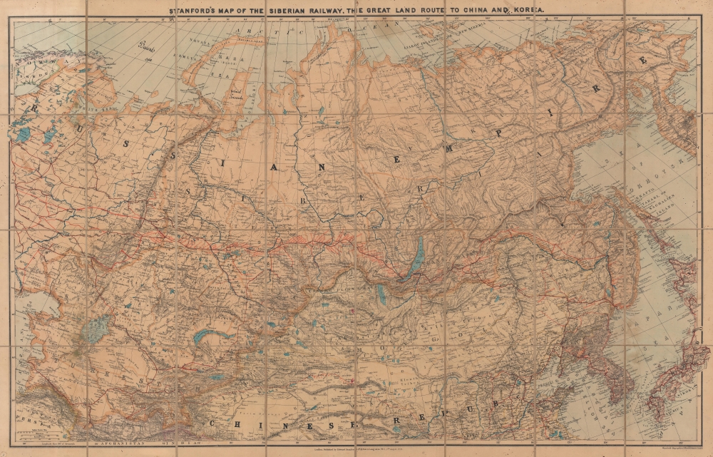
Stanford's Map of the Siberian Railway, the Great Land Route to China and Korea.
1919 (dated) 28.5 x 44.75 in (72.39 x 113.665 cm) 1 : 6000000
1919 (dated) 28.5 x 44.75 in (72.39 x 113.665 cm) 1 : 6000000
Description
This is a 1919 Edward Stanford map of Russia and the Trans-Siberian Railway - issued at the height of the Russian Civil War. Red lines, with major stops noted, highlight the extraordinary achievement of Russian railway engineers. The completion of a railway network across the world's largest continent opened Siberia to settlement, brought Russian influence to China, led to the Russo-Japanese War (1904 - 1905), and influenced the outcome of the Russian Civil War (1917 - 1920).
A Closer Look
The main trunk line of the Trans-Siberian runs like a primary artery across the southern reaches of the Russian Empire, with branch lines extending veinlike into Central Asia, Turkestan, and Manchuria, with connections to Korean and Chinese networks. An even more ambitious proposed route, further south, extends from Russian dependencies in Bokhara, Merv, and Kokand through the deserts of western China to connect with lines in central China. Completion of these lines not only opened trade and internal administration to the far reaches of the sprawling empire, it also gave Russian military forces unfettered access to Afghanistan, British India, and China.The Trans-Siberian Railway and the Russian Civil War
This map was issued against the backdrop of the Russian Civil War - a distant conflict to most Western Europeans, but one with global repercussions. By 1919, when this edition was published, the Russian Civil War had been raging since November 1917, following Russia's exit from World War I (1914 - 1918). Both the Bolsheviks and the White Russians fought over the railway network, with the Bolsheviks finally getting the upper hand.The Trans-Siberian Railway
Russian ambitions to connect Moscow with Vladivostok on the Sea of Japan/Korea began as early as the 1850s. As Russia expanded eastward territorially, its surging population did not follow, leaving vast swaths of fertile land empty of major settlements. Riverways and poorly maintained roads unsuitable for wheeled transport provided the only direct connections to distant frontiers. With the unfolding of the Great Game, the need for a railroad became ever more pressing, as it was the cornerstone of Russian plans to invade not only Central Asia but also access the riches of British India. Despite decades of rejected plans and failed starts, the Trans-Siberian Railroad Committee, personally headed by Tsar Nicholas II, began construction in March 1891. Trains began running in 1904, but construction was not finalized until 1916.Stolypin Reforms and Resettlement
The opening of the Trans-Siberian Railroad coincided with the rise of Pyotr N. Stolypin (1862 -1911). Stolypin served as Minister of Internal Affairs of the Russian Empire. In this role, he instituted a series of revolutionary reforms intended to revitalize Russia's feudal agrarian economy and more effectively capitalize on the empire's vast eastern territories. The Stolypin Reforms (1906 - 1914) transformed the traditional obshchina or open-field communal agriculture system into a capitalist property-based system. Russians willing to move to underdeveloped parts of the empire were offered assistance and concessions. The Stolypin agrarian reforms included numerous resettlement benefits for anyone who moved to Siberia. An Emigration Department was created in 1906. It organized resettlement and assisted settlers during their first years. Settlers received, on average, 16.5 hectares of land per man out of the total allocation of 21 million hectares. Migrants received a small state subsidy, exemption from taxes, access to low-interest credit, and received advice from state-funded agencies specifically developed to help with resettlement. The operation was broadly successful. Between 1890 and 1914, over 10 million people migrated freely from western Russia to areas east of the Urals, generally following the route of the Trans-Siberian Railroad - as can be seen here where red coding illustrates resettlement progress. The reforms were particularly important to Russia's Jewish community, which moved eastward en masse to enjoy greater social, religious, and economic liberty.Chinese Eastern Railway
The most direct route to Vladivostok included traversing Chinese-dominated Manchuria. The Qing Dynasty granted Tsarist Russia a railroad concession through Manchuria. Construction began in 1897 and lasted until 1902. The Chinese Eastern Railway was thus critical to Russian plans to reach Port Arthur and Vladivostok and develop Siberia. The Russo-Japanese War (1904 - 1905), wherein Imperial Japan humiliatingly defeated Russia, as well as increased instability in China, led Stolypin in 1906 to instigate a new track of the Trans-Siberian Railway along the Amur River fully within Russian borders - as shown on this map.Publication History and Census
This map was created and published by Edward Stanford in 1919. Stanford began publishing editions of this map as early as 1904 through at least 1925. This is the only known cataloged example of the 1919 edition.Cartographer
Edward Stanford (May 27, 1827 - November 3, 1904) was one of the most prolific map publishing firms of the late 19th century. The company began as a partnership in 1848 between the 21 year old Edward Stanford and the established map dealer Trelawney Saunders. By 1853 the partnership had dissolved and Edward Stanford took full control of the business. A subsequent series of expansions and exciting new map issues finally led to the production of Stanford's masterwork, "Stanford's Library Map of London". This map is still available and remains somewhat accurate. At the time of publishing it was hailed by the Royal Geographical Society as "the most perfect map of London that has ever been issued". In 1882 Edward Stanford Sr. passed the firm on to his son, Edward Stanford Jr. who continued in his father's proud tradition. Today the Stanford firm still publishes maps and remains one of the most important and prolific cartographic publishers in the world. More by this mapmaker...
Condition
Very good. Dissected and mounted on linen in 32 panels. Light soiling.
References
Rumsey 3303.002 (1910).