This copy is copyright protected.
Copyright © 2024 Geographicus Rare Antique Maps
1868 Hoffmann / Gardner Map of Sierra Nevada and Yosemite Valley, California
SierraNevada-gardner-1868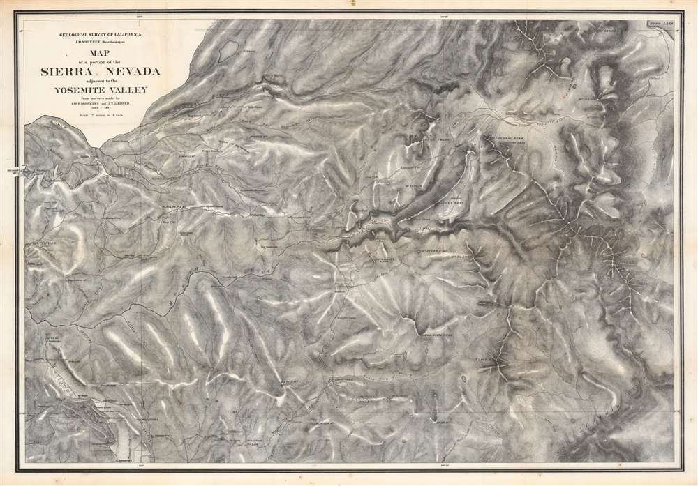


James Terry Gardiner (May 6, 1842 - September 10, 1912), sometimes spelled 'Gardner', was an American surveyor and engineer. Gardiner was born in Troy, New York. He studied at the nearby Rensselaer Polytechnic Institute, and afterwards at the Sheffield Scientific School. In 1863, he joined a childhood friend and geologist Clarence King (January 6, 1842 - December 24, 1901), to travel cross country on horseback to San Francisco - an intimidating and arduous journey. There he worked with the United States Army Corps of Engineers as a civilian assistant and participated in the construction of fortifications on at Fort Mason and Angel Island. From 1964 he worked with the California Geological survey under Josiah Whitney (November 23, 1819 - August 18, 1896). Under Whitney, and often accompanied by King, he embarked on a series of important surveys, including the first scientific survey of the Yosemite Valley and the High Sierra. In 1867 he joined the Fortieth Parallel Survey, led by his friend King. From 1872 - 1876 he was the chief topographer for the Hayden Survey. Afterwards he took a position as director of the State Survey in New York. Meanwhile, he became involved in the mining industry, writing a report on coal and iron in Colorado (1875); serving as vice-president of the coal companies belonging to the Erie Railroad; and becoming president of the Mexican Coke and Coal Company in 1899. With his father-in-law, Bishop William Croswell Doane, he helped establish the community of Northeast Harbor on Mount Desert Island, Maine. There he built a large summer home named, Ye Haven. It still stands today. Gardiner died in Northeast Harbor. More by this mapmaker...
Charles Frederick Hoffman (February 29, 1838 - June 20, 1913) was a German-American topographer. Born in Frankfurt, Germany, Hoffman attended engineering school in Germany before immigrating to the United States. He arrived in California in 1858 and was recruited by Josiah Whitney to the California Geological Survey, where he worked as a topographer. Hoffman is credited with introducing topography to the United States and helped explore the Sierra Nevada Mountains from 1860 to 1870. He then spent 1871 and 1872 as a Professor of Topographical Engineering at Harvard University, before returning to California to continue his work with the California Geological Survey in 1873 and 1874. While a member of the Survey, Hoffman achieved several first ascents of mountains in the Sierra Nevada, including Mount Brewer, Mount Dana, and Tower Peak. After leaving the Survey, Hoffman worked as a consultant for major banking firms and other conglomerates examining and reporting on mining properties in British Columbia, Mexico, Alaska, Siberia, and along the Pacific Coasts of the United States and South America. He founded the Red Point and Hoghead Gravel mines in 1886 - 1887 for the Societe Anonyme de Golden River', a French corporation. He also worked as their manager for many years. Hoffman married Lucy Mayotta Browne in 1870, with whom he had four children. Mount Hoffman in Yosemite National Park, is named in his honor. Learn More...
Julius (Julien) Bien (September 27, 1826 - December 21, 1909) was a German-Jewish lithographer and engraver based in New York City. Bien was born in Naumburg, Germany. He was educated at the Academy of Fine Arts, Cassell and at Städel's Institute, Frankfurt-am-Main. Following the suppression of the anti-autocratic German Revolutions of 1848, Bien, who participated in the pan-German movement, found himself out of favor in his home country and joined the mass German immigration to the United States. Bien can be found in New York as early as 1849. He established the New York Lithographing, Engraving & Printing Company in New York that focused on the emergent chromo-lithograph process - a method of printing color using lithographic plates. His work drew the attention of the U.S. Government Printing Office which contracted him to produce countless government maps and surveys, including the Pacific Railroad Surveys, the census, numerous coast surveys, and various maps relating to the American Civil War. Bien also issued several atlases both privately and in conjunction with a relation, Joseph Bien. At the height of his career Bien was elected president of the American Lithographers Association. After his death in 1909, Bien's firm was taken over by his son who promptly ran it into insolvency. The firm was sold to Sheldon Franklin, who, as part of the deal, retained the right to publish under the Julius Bien imprint. In addition to his work as a printer, Bien was active in the New York German Jewish community. He was director of the New York Hebrew Technical Institute, the New York Hebrew Orphan Asylum, and president of the B'nai B'rith Order. Learn More...
Copyright © 2024 Geographicus Rare Antique Maps | Geographicus Rare Antique Maps
This copy is copyright protected.
Copyright © 2024 Geographicus Rare Antique Maps