1827 Vandermaelen Map of Sindh, Pakistan
Sindh-vandermaelen-1827$650.00

Title
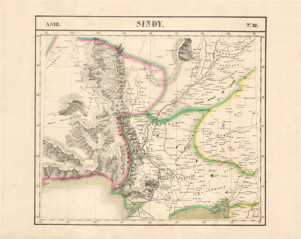
Sindy. Asie no. 81.
1827 (undated) 18 x 20 in (45.72 x 50.8 cm) 1 : 1641836
1827 (undated) 18 x 20 in (45.72 x 50.8 cm) 1 : 1641836
Description
This is the 1827 Vandermaelen map of the lower Indus River valley and the Pakistani province of Sindh. It is the first large-scale atlas map to focus on the area, and the first to be executed in lithography. It includes parts of the Punjab, Balochistan, and Rajasthan in northwestern India, as well as the coast of the Arabian Sea from Omara to modern-day Karachi. Topography is pictorial, illustrating the mountains of the province with vigorous hachuring. The River Indus is shown as far north as Moultan, including its juncture with the River Chinnab.
An Illustrious and Rare Source
The map's detailed geography appears to be strongly informed by Sir Henry Pottinger's 1814 A Map of Beloochistan and Sinde which accompanied Travels in Beloochistan and Sinde. The travelogue describes the future Hong Kong Governor's astonishing journey to map the route between Nushki in Balochistan to Isfahan in Persia, disguised as a Muslim. When Vandermaelen composed the present map, Pottinger's description of these regions would remain unmatched by any European traveler. (Pottinger's map appears to be quite rare; we see no examples on the market or in OCLC, and the book is catalogued in only twelve examples.)Publication History
This map appeared in the second part, 'Asie,' of Vandermaelen's Atlas universel de géographie physique, politique, statistique et minéralogique. The atlas was produced in one edition in 1827; only 810 complete sets were sold. The full set of six volumes appears in eleven institutional collections in OCLC; the 2nd volume alone is listed in 12. Although digitally catalogued via the Rumsey collection, this separate map does not appear physically in any listing in OCLC.CartographerS
Philippe Marie Guillaume Vandermaelen (December 23, 1795 - May 29, 1869) was a Flemish cartographer active in Brussels during the first part of the 19th century. Vandermaelen is created with "one of the most remarkable developments of private enterprise in cartography," namely his remarkable six volume Atlas Universel de Geographie. Vandermaelen was born in Brussels in 1795 and trained as a globe maker. It was no doubt his training as a globe maker that led him see the need for an atlas rendered on a universal scale in order that all bodies could be understood in relation to one another. In addition to his great work Vandermaelen also produced a number of globes, lesser maps, a highly detailed 250 sheet map of Belgium, and several regional atlases. More by this mapmaker...
Sir Henry Pottinger (砵甸乍, October 3, 1789 – 18 March 18,1856) was an Anglo-Irish soldier and colonial administrator who became the first Governor of Hong Kong. Pottinger represents the absolute best of the British East India Service. He was born in County Down, Ireland and studied at the Belfast Academy before joining the army in India in 1804. In 1806, he joined the British East India Company, serving as a Lieutenant in the 1809 Anglo-Mahratta Wars. In the following year, he partnered with Charles Christie on a bold expedition to map the route from Nushki (Balochistan) to Isfahan (Central Persia). He and Christie disguised themselves as Muslims, separated ways, and both mapped separated routes, before they rejoined in Isfahan. It would be 100 years before another European took this route. The achievement earned him a promotion to Colonel. He became the Resident Administer of Sindh in 1820, and of in the 1830s. In 1839 word reached India that he was to be ennobled and he returned to England to accept the rank of Baronet.
One year later, in 1841, he accepted Foreign Secretary Lord Palmerston's offer to become envoy and plenipotentiary in China and superintendent of British trade. There can be little doubt that he acquired this map at that time, in anticipation of his voyage to China and subsequent posting. The fact that this is the first edition, 1840, rather than the updated 1841 edition, suggests he must have acquired it in London early in 1841.
His instructions from Palmerston included specific instructions regarding Hong Kong,
…examine with care the natural capacities of Hong Kong, and you will not agree to give up that Island unless you should find that you can exchange it for another in the neighborhood of Canton, better adapted for the purposes in view; equally defensible; and affording sufficient shelter for Ships of War and Commerce.Palmer went on to negotiate the 1842 Treaty of Nanking, which ended the First Opium War, resulting in the cession of Hong Kong Island to the British Crown. Pottinger subsequently became the second Administrator of Hong Kong (1841–1843) and the first Governor of Hong Kong (1843–1844). Pottinger was enamored of the island, writing,
the retention of Hong Kong is the only point in which I have intentionally exceeded my modified instructions, but every single hour I have passed in this superb country has convinced me of the necessity and desirability of our possessing such a settlement as an emporium for our trade and a place from which Her Majesty's subjects in China may be alike protected and controlled. Of course, he was correct and Hong Kong went to become the crown jewel of British colonial enterprise in the far east. Pottinger afterwards went on to be governor of the Cape Colony in 1847, and Governor of Madras in 1848. Learn More...
Source
Vandermaelen, P., Atlas universel de geographie physique, politique, statistique et mineralogique, (Bruxelles: Vandermaelen) 1827.
Atlas Universel de Geographie. This great work, featuring some 378 unique maps and compiled over three years, was the first lithograph atlas, and the first to render the world on the same projection and at a uniform scale. It was no doubt Vandermaelen’s training a globe maker that led him see the need for an atlas rendered uniformly so that all bodies could be understood in relation to one another. As a result, many newly emerging areas received more attention than prior efforts. Maps of the American West, in particular, benefited: ‘no mapmaker had previously attempted to use such a large scale for any western American area.’ (Wheat). Central and South Asia also appear in sharper focus. Despite Vandermaelen’s reliance upon existing sources, his maps very frequently provided the clearest depictions available of many poorly-understood parts of the world. The atlas was an expensive production, costing $800 in 1827. Subscription lists indicate that only 810 full sets of the atlas were sold. It was printed on high-quality paper with superior hand coloring and was engraved in a clear, legible style. Conjoined, the maps of Vendermaelen's atlas would create a massive globe some 7.75 meters in diameter, a feat which was accomplished at the Etablissement Geographique de Brussels.
Condition
Excellent. Original outline color, wide margins and no repairs.
References
Rumsey 2212.113.