This item has been sold, but you can get on the Waitlist to be notified if another example becomes available, or purchase a digital scan.
1923 Japanese Nautical Chart / Map of Singapore Island and Strait
Singapore-hydyographicdept-1923$925.00

Title
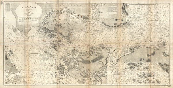
China Sea Singapore Strait.
1923 (dated) 27 x 53 in (68.58 x 134.62 cm)
1923 (dated) 27 x 53 in (68.58 x 134.62 cm)
Description
This is a rare and striking large format 1923 Japanese nautical chart of Singapore Strait. Centered on Singapore Island, this maritime map covers from Great Karimum Island in the west quadrant to Pulo Bintang in the east, it extends north as far as the Malay Peninsula and Jahore Strait and as far south as Pulo Bulan. Cartographically this map references 19th century British Admiralty charts of the same region with numerous updates to 1923. Throughout there is a wealth of practical information for the mariner, including notations on tides, anchorage, shipping lanes, and countless depth soundings in fathoms. Offers some inland detail particularly on Singapore Island and Singapore City. Most text is in English but there are also number of Japanese titles and annotations. Japanese Hydrographic Department stamps appear in the upper left margin and on the verso. Represents Hydrographic Department Chart no. 624.
CartographerS
The Hydrographic Department of Japan (1871 - present) was established in 1871 to carry out various marine surveys and observations for the Japanese military. Initially the Hydrographic Department did little more than collect and update British Admiralty and U.S. Hydrographic charts focusing on East Asia, however, as the department matured, it began to commission its own survey work through the region. Today the Hydrographic department has been folded into the Japanese Coast Guard's Hydrographic and Oceanographic Department. More by this mapmaker...
The British Admiralty Office (1795 - Present) or the United Kingdom Hydrographic Office refers to the Branch of the English government that is responsible for the command of the British Navy. In 1795 King George III created the United Kingdom Hydrographic Office, known in short as the U.K.H.O., to provide top notch nautical charts to the vast Royal Navy. Prior the founding of the Admiralty the surveying and creation of nautical charts was primarily a commercial venture wherein the cartographer himself, more of than not, actually financed the printing of his own material. The great navigator Cook himself is known to have scrambled for funds to publish his own seminal charts - the most important and advanced of the period. The system of privately funded nautical mapping and publishing left vast portions of the world uncharted and many excellent charts unpublished. King George III, responding significant loss in trade revenue related to shipwrecks and delay due to poor charts, recognized the need for an institutionalized government sponsored cartographic agency - the Admiralty. The first head of the Admiralty, a position known as Hydrographer, was the important cartographer Alexander Dalrymple. Dalrymple started by organizing and cataloging obtainable charts before initiating the laborious process of updating them and filling in the blanks. The first official Admiralty Chart appeared in 1800 and detailed Quiberon Bay in Brittany. By 1808 the position of Hydrographer fell to Captain Thomas Hurd. Hurd advocated the sale of Admiralty charts to the general public and, by the time he retired in 1829, had issued and published some 736 charts. Stewardship of the organization then passed to Rear Admiral Sir Francis Beaufort. It was under Beaufort's administration that the Admiralty truly developed as a "chart making" as opposed to a "chart cataloging" institution. Beaufort held his post from 1829 to 1854. In his 25 years at the Admiralty Beaufort created nearly 1500 new charts and sponsored countless surveying and scientific expeditions - including the 1831 to 1836 voyage of the H.M.S. Beagle. By 1855 the Admiralty's chart catalog listed some 1,981 charts. Learn More...
Condition
Good. Some toning on original fold lines. Japanese government stamps to margins. Professional reinforcement of folds on verso.