1949 Survey Department of Malaya City Plan of Singapore
SingaporeTown-surveydeptmalaya-1949$700.00

Title
Singapore Town.
1949 (undated) 13.75 x 10.5 in (34.925 x 26.67 cm) 1 : 20000
1949 (undated) 13.75 x 10.5 in (34.925 x 26.67 cm) 1 : 20000
Description
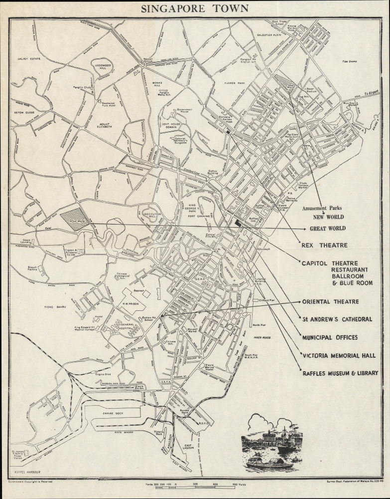
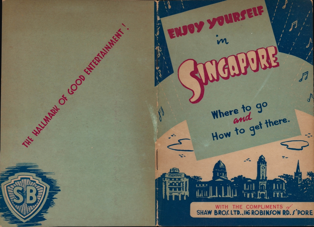
An unusual and rare c. 1949 folding map of Singapore produced by Shaw Brothers, a film and entertainment powerhouse, using data from the Survey Department of Malaya. It depicts Singapore during its recovery from World War II (1939 - 1945) and emphasizes the opportunities for entertainment provided by Shaw Brothers establishments.
Perhaps most noticeably, a series of buildings are designated with arrows connecting to text at right. Most of these, including the Great World and New World Amusement Parks, Capitol Theatre, Oriental Theatre, and Rex Theatre, all belonged to Shaw Brothers, an entertainment dynamo that was (and remains) a household name throughout the Chinese Diaspora. These sites were mainstays of entertainment for the masses in Singapore and loom large in the popular memory of older and middle-aged Singaporeans today.
World War II was a major setback for the company, but they rebuilt and achieved new levels of success in the postwar period (reportedly with the help of $4 million in gold and other assets they buried in their yard during the Japanese occupation). The earlier move to Hong Kong proved a blessing in disguise, as most of their Shanghai-based competitors were wiped out by the one-two punch of World War II and the Communist Revolution. In 1961, the company built Movietown in Hong Kong, the largest privately-owned film studio in the world at the time, and from there produced many of the most celebrated martial arts (wuxia) films of the 1960s and 1970s.
The studio's Singapore operations were managed by the youngest brother of the family, Run Run Shaw (邵仁楞), who proved to be even more skilled than his brothers in business matters. From an early date, the Shaw Brothers realized that controlling the distribution and screening of their films was essential to their success and they began to operate theaters in Shanghai, Hong Kong, Singapore, and Malaya. They also opened amusement parks that included movie theaters, restaurants, night clubs, games, and more.
Like big film studios in other parts of the world, the Shaw Brothers ran into difficulties in the 1970s, pushing them to focus more on television and investing in foreign productions. The company's film and television productions were gradually wound down from the 1980s onwards, but a parent company, Shaw Organization, continues to operate, focusing on distribution and theaters. It remains the biggest distributor in Asia, operating 7 theaters in Singapore alone, while also maintaining a robust real estate portfolio.
A dedicated philanthropist and colorful personality, Run Run Shaw was one of the most recognizable grandees in Hong Kong and throughout the Chinese Diaspora. He was knighted by Queen Elizabeth II in 1977 and lived to the age of 106, dying in early 2014.
A Closer Look
Coverage includes the most developed portion of Singapore on the southeast side of the island. Major roads, railways, port facilities, and public institutions - prisons, hospitals, power stations, schools, and government offices - are indicated throughout. Parks, military facilities, suburban areas, and major landmarks like the Raffles Hotel and Government House are also labeled. A small, illustrated vignette of ships near a waterfront defined by colonial architecture sits at bottom.Perhaps most noticeably, a series of buildings are designated with arrows connecting to text at right. Most of these, including the Great World and New World Amusement Parks, Capitol Theatre, Oriental Theatre, and Rex Theatre, all belonged to Shaw Brothers, an entertainment dynamo that was (and remains) a household name throughout the Chinese Diaspora. These sites were mainstays of entertainment for the masses in Singapore and loom large in the popular memory of older and middle-aged Singaporeans today.
Hong Kong's Hollywood
This map was issued as a promotional piece for Shaw Brothers, arguably the most dynamic and successful Chinese-language film production company of the era, especially once the studios in Shanghai fell under the censorship regime of the Chinese Communist Party. The brothers Runje, Runme, and Runde Shaw (邵, Shao in pinyin) formed the Tinayi Film Company in Shanghai in 1925. Finding early success, including producing some of the earliest Chinese-language 'talkies,' the entrepreneurial brothers expanded operations to Hong Kong, Malaya, and Singapore, shifting their main operations to Hong Kong in the mid-1930s when the Nanjing Government banned martial arts films, which were lucrative for the studio.World War II was a major setback for the company, but they rebuilt and achieved new levels of success in the postwar period (reportedly with the help of $4 million in gold and other assets they buried in their yard during the Japanese occupation). The earlier move to Hong Kong proved a blessing in disguise, as most of their Shanghai-based competitors were wiped out by the one-two punch of World War II and the Communist Revolution. In 1961, the company built Movietown in Hong Kong, the largest privately-owned film studio in the world at the time, and from there produced many of the most celebrated martial arts (wuxia) films of the 1960s and 1970s.
The studio's Singapore operations were managed by the youngest brother of the family, Run Run Shaw (邵仁楞), who proved to be even more skilled than his brothers in business matters. From an early date, the Shaw Brothers realized that controlling the distribution and screening of their films was essential to their success and they began to operate theaters in Shanghai, Hong Kong, Singapore, and Malaya. They also opened amusement parks that included movie theaters, restaurants, night clubs, games, and more.
Like big film studios in other parts of the world, the Shaw Brothers ran into difficulties in the 1970s, pushing them to focus more on television and investing in foreign productions. The company's film and television productions were gradually wound down from the 1980s onwards, but a parent company, Shaw Organization, continues to operate, focusing on distribution and theaters. It remains the biggest distributor in Asia, operating 7 theaters in Singapore alone, while also maintaining a robust real estate portfolio.
A dedicated philanthropist and colorful personality, Run Run Shaw was one of the most recognizable grandees in Hong Kong and throughout the Chinese Diaspora. He was knighted by Queen Elizabeth II in 1977 and lived to the age of 106, dying in early 2014.
Historical Context
Published in the wake of World War II, at the time Singapore was still recovering from the Japanese invasion and occupation. Despite being touted as the 'Gibraltar of Asia,' Singapore endured years of brutal occupation in which the city's Chinese community was especially targeted by the occupiers. After the war, Britain's prestige was in tatters, and it was clear that power had to be handed over to local actors. The only question was the pace of change and the shape of the subsequent government. Economic troubles led to high levels of discontent in Singapore and Malaya, feeding anti-colonial and left-wing political movements. Despite efforts to forestall transition to independence, the British were forced to widen the franchise, resulting in the election of a left-wing government led by the Labor Front in 1955. The new government's hard line against radical left-wing groups helped convince London to grant de facto independence with the State of Singapore Act, which passed the British Parliament in 1958. Over the following decade, Singapore would join and then be expelled from Malaysia, resulting in the independent city-state that exists today.Publication History and Census
This map was made by the Survey Department of Malaya, whose name indicates a date between 1948 and 1963, but from context and from the designation 'No. 205-49' can be tentatively dated to 1949. The map is not known to exist in any institutional collections, but a larger map with the same title issued by the Survey Department of Malaya, very likely the original on which this map is based, is held by the University of Iowa, the University of Chicago, and the National Library Board of Singapore (OCLC 62334717).Cartographer
Survey Department, Federation of Malaya (1885 - present), today the Department of Survey and Mapping Malaysia (Jabatan Ukur dan Pemetaan Malaysia, abbreviated as JUPEM), has origins in the Department of Survey, Johor, established in 1885. The survey departments of the various states and settlements of Malaya were gradually merged and formally placed under a single administration upon independence in 1957, though to this day JUPEM is divided into units according to state that are generally successors to the former survey departments of the individual states. More by this mapmaker...
Condition
Good. Even toning across upper left quadrant.