1886 Imray Blueback Nautical Map of Argentina, Chile, Antarctica
SouthAmericaSouth-imray-1886$1,500.00


Title
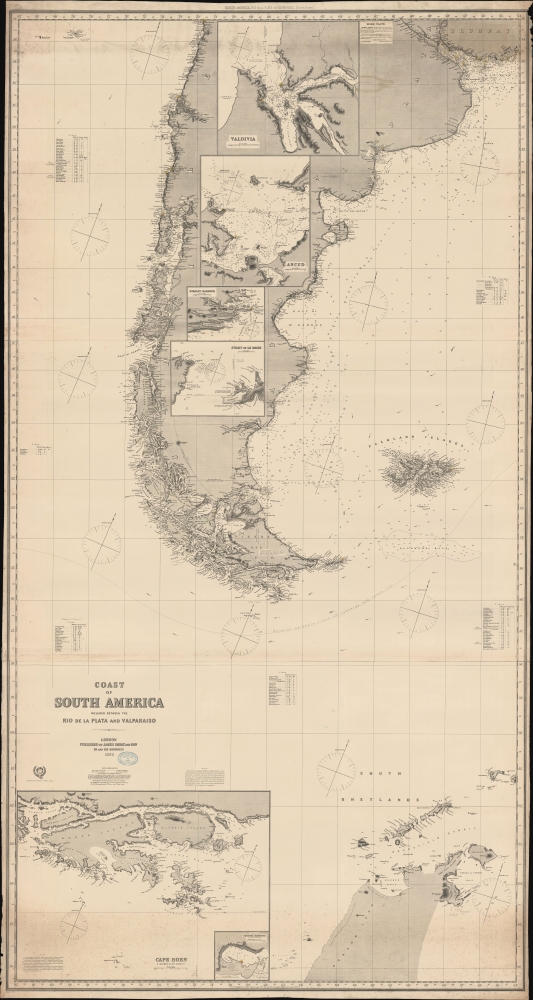
Coast of South America included between the Rio de la Plata and Valparaiso.
1886 (dated) 81 x 44 in (205.74 x 111.76 cm) 1 : 2750000
1886 (dated) 81 x 44 in (205.74 x 111.76 cm) 1 : 2750000
Description
A massive 1886 Imray nautical map illustrating the coasts of southern South America, including Argentina, Chile, the Falkland Islands (Malvinas), Tierra del Fuego, and the northernmost parts of Antarctica. The map was designed for mariners navigating the treacherous waters of Drake's Passage south of Cape Horn - or navigating to the South Shetlands.
A Closer Look
Coverage embraces the southern parts of South America, from Valparaiso, Chile, and Uruguay, south to include Cape Horn, Drake's Passage, the South Shetland Islands, the Falklands (Malvinas), and tenuously mapped parts of Antarctica. It includes insets of Valdivia, Ancud, Stanley Harbour, and the Strait of Le Maire. Soundings south of Cape Horn are notably sparse, and an annotation makes clear these are dangerous seasAs the coast included within its limits, especially that south of Magellan strait as far as Cape Horn and thence westward and northward, as far as lat. 42°S., is still very imperfectly known, shipmasters should avoid making too free with it. In that part it is nearly everywhere extremely wild and desolate, and should be approached only with the greatest possible caution. Kelp abounds, and generally indicates proximity of rocks dangerous to navigation.One wonders at the extent of coverage, embracing the waters off the horn of Antarctica (Palmer Land). This is likely a legacy of the sealing craze that took many entrepreneurial ships to the South Shetland Islands in the early to mid-19th century. It may also have been useful to navigators bold enough to brave the Antarctic Convergence and unfortunate enough to have to seek shelter on those harsh shores.
Ushuaia
A larger inset at the base of the map details the Beagle Channel and the Ushuaia (Ushiwia) Mission Station. Notes direct navigators in peril or shipwrecked on how to find and access the station and which indigenous settlements are likely to be friendly - or the opposite. The station was established in the mid-19th century by British missionaries attempting to convert the local populace. It quickly began appearing on nautical charts as the only place of refuge within hundreds (if not thousands) of miles from Cape Horn. It enjoyed a population boom in the mid-1880s when it was believed rich gold deposits were to be found in the surrounding country, but this hope proved false. Today, Ushuaia has a population of 82,600 people and is considered the world's southernmost city.Blueback Charts
Blueback nautical charts began appearing in London in the late 18th century. Bluebacks, as they came to be called, were privately published large-format nautical charts known for their distinctive blue paper backing. The backing, a commonly available blue manila paper traditionally used by publishers to wrap unbound pamphlets, was adopted as a practical way to reinforce the low-quality paper used by private chart publishers in an effort to cut costs. That being said, not all blueback charts are literally backed with blue paper. The earliest known blueback charts include a 1760 chart issued by Mount and Page and a 1787 chart issued by Robert Sayer. The tradition took off in the early 19th century, when British publishers like John Hamilton Moore, Robert Blachford, James Imray, William Heather, John William Norie, Charles Wilson, David Steel, R. H. Laurie, and John Hobbs, among others, rose to dominate the chart trade. Bluebacks became so popular that the convention was embraced by chartmakers outside of England, including Americans Edmund March Blunt and George Eldridge, as well as Scandinavian, French, German, Russian, and Spanish chartmakers. Blueback charts remained popular until the late 19th century when government-subsidized organizations like the British Admiralty Hydrographic Office and the United States Coast Survey began issuing their own superior charts on high-quality paper that did not require reinforcement.Publication History and Census
This map was published by Imray and Sons in London in 1886, with the present example bearing updates to 1887 - likely referencing pastedowns, as this is a stamp, not a plate update. We have identified no other examples of the present state, and the map is not present in any edition in the OCLC, but the Greenwich Maritime Museum does have an 1888 example.Cartographer
James Imray (May 16, 1803 - November 15, 1870) was a Scottish hydrographer and stationer active in London during the middle to latter part of the 19th century. Imray is best known as a the largest and most prominent producer of blue-back charts, a kind of nautical chart popular from about 1750 to 1920 and named for its distinctive blue paper backing (although not all charts that may be called "blue-backs" actually have a blue backing). Unlike government charts issued by the British Admiralty, U.S. Coast Survey, and other similar organizations, Imray's charts were a private profit based venture and not generally the result of unique survey work. Rather, Imray's charts were judicious and beautiful composites based upon pre-existing charts (some dating to the 17th century) and new information gleaned from governmental as well as commercial pilots and navigators. Imray was born in Spitalfields, England, the eldest son of a Jacobite dyer also named James. Imray did not follow his father profession, instead apprenticing to William Lukyn, a stationer. He established himself as a bookseller and bookbinder at 116 Minories Street, where he shared offices with the nautical chart publisher Robert Blanchford. In 1836 Imray signed on as a full partner in Blanchford's enterprise, christening themselves Blanchford & Imray. At this time the Blanchford firm lagged far behind competing chart publishers Norie and Laruie, nevertheless, with the injection of Imray's marketing savvy the firm began a long rise. James Imray bought out Blanchford's share in 1846, becoming the sole proprietor of the chart house, publishing under the imprint of James Imray. Relocating in 1850 to larger offices at 102 Minories, Imray was well on track to become the most prominent chart publisher in London. In 1854, when Imray's 25 year old son, James Frederick Imray, joined as a full partner, the firm again changed its imprint, this time to James Imray and Son. The elder Imray was a master of marketing and was quick to respond to trade shifts and historic events. Many of his most successful charts were targeted to specific trade routes, for example, he issued charts entitled "Cotton Ports of Georgia" and "Rice Ports of India". Other charts emerged quickly following such events as the 1849 California Gold Rush. Imray's rise also coincided with the development of governmental mapping organizations such as the Admiralty and the U.S. Coast Survey, whose work he appropriated and rebranded in practical format familiar to navigators. Imray's death in 1870 marked a major transition in the firm's output and began its decline. Though Imray's son, James Frederick, excelled at authoring pilot books he had little experience with charts and issued few new publications. Most James Frederick Imray publications issued from 1870 to 1899 were either revisions of earlier maps prepared by his father or copies of British Admiralty charts. Charts from this period are recognizable as being less decorative than the elder Imray's charts following the stylistic conventions established by the Admiralty. The Admiralty itself at the same time began to rise in prominence, issuing its own official charts that were both cheaper and more up to date than those offered by private enterprises. By the end of the century the firm was well in decline and, in 1899 "James Imray and Son" amalgamated with the similarly suffering "Norie and Wilson", which was itself acquired by Laurie in 1904. Today it continues to publish maritime charts as "Imray, Laurie, Norie and Wilson". More by this mapmaker...
Condition
Very good. Some soiling and edge wear. Slight loss upper right corner.
References
Greenwich Maritime Museum, G279:4/13.