Digital Image: 1687 Wagner Map of Southeast Asia (Malaya, Thailand, Singapore)
SoutheastAsia-wagner-1687_d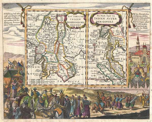

Title
Ein Theil Von Indien Auserhalb Des Ganges. / Die Halb-Insul von Indien Auser Dem Ganges.
1687 (undated) 11 x 14 in (27.94 x 35.56 cm) 1 : 18000000
1687 (undated) 11 x 14 in (27.94 x 35.56 cm) 1 : 18000000
Description
FOR THE ORIGINAL ANTIQUE MAP, WITH HISTORICAL ANALYSIS, CLICK HERE.
Digital Map Information
Geographicus maintains an archive of high-resolution rare map scans. We scan our maps at 300 DPI or higher, with newer images being 600 DPI, (either TIFF or JPEG, depending on when the scan was done) which is most cases in suitable for enlargement and printing.
Delivery
Once you purchase our digital scan service, you will receive a download link via email - usually within seconds. Digital orders are delivered as ZIP files, an industry standard file compression protocol that any computer should be able to unpack. Some of our files are very large, and can take some time to download. Most files are saved into your computer's 'Downloads' folder. All delivery is electronic. No physical product is shipped.
Credit and Scope of Use
You can use your digial image any way you want! Our digital images are unrestricted by copyright and can be used, modified, and published freely. The textual description that accompanies the original antique map is not included in the sale of digital images and remains protected by copyright. That said, we put significant care and effort into scanning and editing these maps, and we’d appreciate a credit when possible. Should you wish to credit us, please use the following credit line:
Courtesy of Geographicus Rare Antique Maps (https://www.geographicus.com).
How Large Can I Print?
In general, at 300 DPI, you should at least be able to double the size of the actual image, more so with our 600 DPI images. So, if the original was 10 x 12 inches, you can print at 20 x 24 inches, without quality loss. If your display requirements can accommodate some loss in image quality, you can make it even larger. That being said, no quality of scan will allow you to blow up at 10 x 12 inch map to wall size without significant quality loss. For more information, it is best consult a printer or reprographics specialist.
Refunds
If the high resolution image you ordered is unavailable, we will fully refund your purchase. Otherwise, digital images scans are a service, not a tangible product, and cannot be returned or refunded once the download link is used.
Cartographer S
Johann Christoph Wagner (1640 – c. 1701) was a German theologian, mathematician, and writer active in the 17th century. Wagner was born in Nuremberg where his father, Christoph Wagner, was a cantor at St. Egidien. Wagner studied in Altdorf where he defended works on astrological medicine and the occult properties of abbreviations. Unable to find work in Nuremberg he took to published calendars for astrological work. Around 1680 he relocated to Augsburg where he published, among other things, his well-known descriptions of the orient. More by this mapmaker...
Melchior Haffner II (1660- November 1, 1704) was a prominent German engraver active un Augsburg during the second half of the 17th century. Haffner was born in Ulm and apprenticed as an engraver under his father of the same name. He married in Ulm around 1683. Shortly after he relocated to Augsburg where is began his own successful engraving business. He appears to have worked mostly for book publishers producing portraits, frontispieces, and bookplates, as well as a few maps. Several important maps are included in his corpus including maps of China issued for Ferdinand Verbiest (1623-1688) and the maps and other engravings included in Jean-Baptiste Tavernier's Les Six Voyages. Haffner II is not to be confused with this father, Melchior Haffner I, of Ulm, who was also an engraver. Learn More...
Source
Wagner J. C., Interiora Orientis Detecta, Oder Grundrichtige und eigentliche Beschreibung aller heut zu Tag bekandten grossen und herrlichen Reiche des Orients, (Augsburg: Koppmeyer) 1687.
References
OCLC 225409259.